Ask an Expert: An In-Depth Look at Reveal™ Imagery

Captured with EagleView’s next-generation imaging system, Reveal™ imagery is revolutionizing the way professionals see the world.

Thom Salter, Director of Product Strategy at EagleView
Reveal imagery from EagleView is the finest, sharpest, and highest-resolution available, uncovering incredible structural and property details within each image. This ultra-high-resolution aerial imagery is for those who need more clarity, more detail, and more certainty in their workflows.
Thom Salter, Director of Product Strategy, has witnessed the evolution of aerial imagery firsthand in his role at EagleView. Thom joined the business, then under the Pictometry brand, in 2000 and has held various roles in the organization that pertain to imagery technology.
Today, Thom helps EagleView lead the way in image capture with this newest ultra-high-resolution imagery. We spoke to Thom to learn more about Reveal imagery and find out why it has sparked a Resolution Revolution across industries.
How is Reveal imagery captured?
Reveal imagery is captured using EagleView’s next-generation camera systems. Unlike previous camera systems, these sensors, mounted onto fixed-wing aircraft, can capture ultra-high-resolution imagery from higher altitudes.
In what ways has aerial imagery evolved since the inception of Pictometry imagery?
When it was first conceived, Pictometry® imagery revolutionized the way people saw the world. Not only did it offer an oblique perspective, but for the first time, that oblique image was also georeferenced. This means that each pixel corresponds to specific latitude/longitude coordinates. The images are also metric—that is, you can make measurements, including height, on them. Pictometry images are more than simply pretty pictures. They can provide precise location data to those who need to make critical decisions.
Primarily, aerial imagery has evolved when it comes to image resolution. Technology enables us to capture finer and finer details within the imagery.
Reveal imagery takes the guesswork out of workflows thanks to simpler feature identification and object recognition.
What is ground sample distance, and why is it so important?
Ground sample distance, or GSD, is the individual unit of measurement, or pixel, in the image. For example, an image with a one-inch GSD means that each pixel represents a one-inch-by-one-inch space on the ground.
Traditionally, satellite imagery and other low-resolution forms of image capture can have anywhere from a one- to three-foot GSD. When looking at the image, you won’t be able to zoom in very far and see fine details. On your screen, that one-foot-by-one-foot space won’t bear much resemblance to its real-life counterpart.
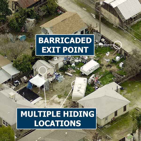
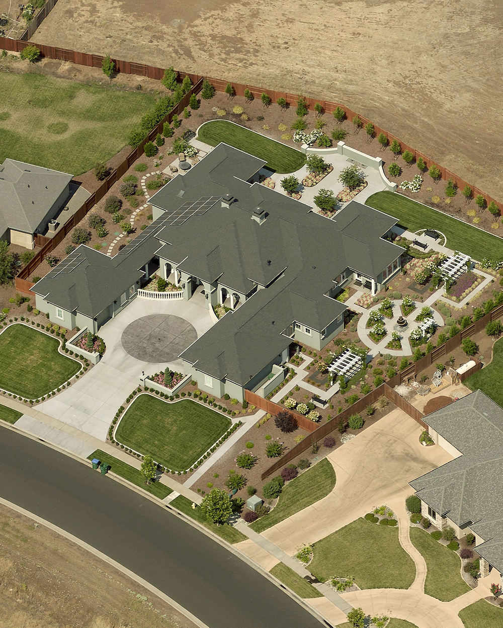
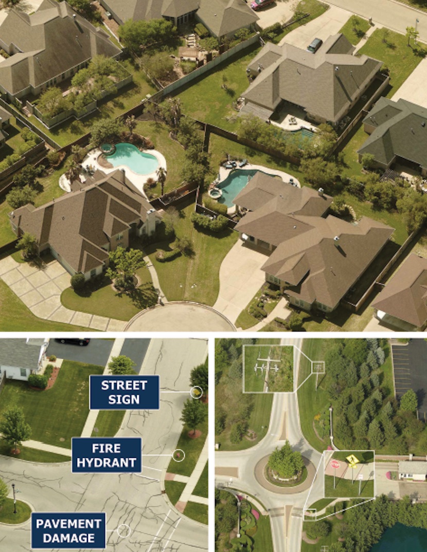
With Reveal imagery, authorities can spot potential hazards and nuisances on properties.
Until now, the most cutting-edge imagery on the market has generally been two-inch GSD, with the most widely available at three-inch GSD. This type of imagery shows far more detail than satellite imagery.
Reveal imagery takes that clarity to another level with a sub-one-inch GSD. Reveal imagery has a GSD as fine as 0.75 inches, 16 times as many pixels as three-inch imagery, which enables easier object recognition for those who need answers fast.
What advantages does Reveal have over other methods of image capture?
The use of unmanned aerial systems, or drones, to capture images is gaining popularity. However, both due to Federal Aviation Administration regulations and the limitations of the technology itself, a drone cannot capture imagery at the municipal or neighborhood scale.
Reveal is unique because for the first time you don’t have to sacrifice coverage for clarity. Captured from high-altitude aircraft with variable-aim cameras, Reveal provides a detailed and consistent viewing experience from property to property—across your entire area of interest—while still reducing the number of days to complete the capture project.
Customers who have experienced Reveal imagery are reluctant to go back to six-, four-, or even three-inch imagery products. In terms of the difference in resolution, I’d compare this to getting a new pair of glasses and then having to go back to an older prescription a few weeks later. You’d miss the clarity to which you had become accustomed.
How does Reveal imagery signal a Resolution Revolution?
An example of the details seen in Reveal imagery.
The use cases for Reveal are myriad. Reveal imagery enables our customers in government to make crucial and timely decisions and keep their communities safe and thriving:
- Assessors can view and analyze property elements right from their desks to complete fair and equitable property valuations.
- Public safety personnel have the intelligence they need to plan for critical missions in the field, where small details can mean the difference between life and death.
- Public works departments can identify infrastructure elements, such as roads and bridges, in need of repair.
Private-sector businesses can also benefit from Reveal imagery:
- Insurance carriers can view property and roof condition indicators in sharp detail whether they are processing claims or underwriting a new or renewed policy.
- Electric utilities can monitor assets without needing a field visit or more effectively determine when field visits are essential.
Following a natural disaster, such as the devastation resulting from Hurricane Michael, our customers can access Reveal imagery in as little as 24 to 48 hours of capture. With this highly accurate data, insurance claims adjusters, assessment officials, public safety and emergency management personnel, utility companies, and other professionals are all able to help affected communities get back on their feet following a catastrophic event.
By providing our customers with up-to-date, ultra-high-resolution imagery, they experience streamlined workflows and have greater confidence when they make decisions that impact so many people.