When first introduced to
imagery from EagleView®, then known as Pictometry
®, Linda Griggs, assessor, and Liz Kriegel, deputy assessor, for Iowa County, Iowa, were not familiar of the benefits of the technology. EagleView flew the county in 2009 through a grant with five other counties in the state; however, the imagery wasn’t readily utilized by their office.
Even with access to aerial imagery, the team stuck to their traditional methods of
assessing properties. However, with an office of only four employees and 18,000 parcels, the job of assessing the agriculturally heavy county became challenging, causing the staff to think outside of the box on ways to handle field visits.
When it was time for the county to consider options for aerial photography, Griggs and Kriegel looked for a product that would not only provide imagery for all offices, but could also assist their office with a solution to time consuming field work. Purchasing
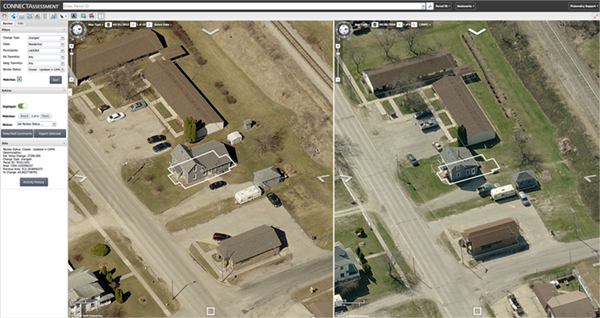
ChangeFinder™ in addition to the imagery was the end result. ChangeFinder is an EagleView technology that compares current imagery to previous imagery using GIS polygon outlines for analysis of changes in size and shape. Assessors can use this data to have immediate understanding of property changes in their county.
Once Kriegel began comparing the old imagery to the new, she saw the changes and they were impressive. By reviewing the parcels one-by-one in
CONNECTAssessment™, and showing the other staff members the significance of the changes, everyone was on board to review--making their process more efficient.
“It’s impossible to quantify the amount of time we’ve saved. We were able to get through all of our changes in three or four months rather than the average seven or eight,” Kriegel stated. The majority of Iowa County has no requirements for building permits, meaning that buildings are constantly added, reworked and torn down. When driving through the county and physically performing field visits, there is no way to find exact measurements of each property. Assessments are merely a guess if the building looks like the right size. Aiming to be fair and accurate, Griggs knew that EagleView was the right solution.
“You could look at the aerial imagery next to each other, but the difference could be so subtle that we wouldn’t notice the change, until we began using ChangeFinder,” Griggs stated. “The outlining of the changes in the imagery really makes the additions or demolitions stand out.”
With the ChangeFinder data the assessors are able to filter what they are looking for when they are searching parcels. “We’ve looked at several parcels multiple times and in different ways. We’ve looked specifically at decks, patios, additions and more,” said Griggs. “We’re now able to look at it from different levels and perspectives and track those. We’ll even mark properties in CONNECTAssessment that we want to investigate further.”
When a resident adds on to or modifies a property, the assessor’s office in Iowa County would send a letter asking whether or not they have a new addition to their property, allowing the resident to report if they have made changes. Now with the ChangeFinder data, the wording of the letter can become more specific, asking about the dimensions and the location.
“We now can flag a parcel on CONNECTAssessment and send out a letter requesting in-depth information about the new building,” Kriegel stated. “If they deny the change on their property, we would simply print out the document and show them the picture as proof.”
Between flying in 2009 and 2015, the county has discovered nearly $2 million in value. Not only has the amount of money found validated the use of the technology, but the time saved, increased safety for the employees and the workflow process improvement have truly made a difference in the assessors’ eyes.
“Not many people realize how dangerous field visits can be. We note when we can’t go to certain areas and EagleView imagery helps so much with that,” Griggs said. “We’re not missing anything with ChangeFinder because we’re still capable of looking into what we’re unable to see in person in that area.”
“We’ve driven down crazy and unsafe paths before to get to hidden cabins along the rivers,” Kriegel commented. “These are places we never would’ve been able to find or get to without EagleView.”
In some cases, uncontrollable circumstances keep the assessors from performing their field visits. “Many parcels are owned by urban residents who venture into the county on weekends, gating their property on the weekdays, making our job much more difficult,” explained Griggs.
Assessing farms in Iowa County presents challenges because assessors aren’t permitted to travel from one farm to the next. Doing so could unknowingly transfer bacteria or diseases that could be devastating to farm animals. Accessing these farms from the office lessens the risk of spreading these health hazards.
Time saved has made a huge difference with such a small staff and so many parcels to assess. Two members of the staff will go out for field visits together at a single time, leaving only two sets of hands working in the office at once. EagleView imagery allows the other two employees to be working steadily from their desktops assessing parcels while the others are in the field, getting more done than they were capable of previous to EagleView.
After wondering for years what EagleView imagery and tools could do for the assessor’s office, the answers were clear after 2015. “Instead of questioning, ‘what if?’ we’re able to say that this technology has truly given us confidence in our daily tasks,” commented Griggs. “We’re able to send out every letter feeling assured that we know that we’re requesting the correct information.”
After the success in the assessor’s office, there are high hopes for EagleView imagery to be utilized in other departments in Iowa County in the future.
“People don’t realize the capabilities of this technology, including us at first,” Kriegel concluded. “It’s safe to say that the benefits we’ve seen and the value it has added was completely worth it.”