November 6, 2018
 Most government agencies are aware that they can see a top-down (orthogonal) view with aerial imagery. However, this perspective is limiting and doesn't enable users to see the sides of buildings or gain other insight into a location. Additionally, certain types of ortho imagery, such as satellite, can't reveal fine details.
The use cases for aerial imagery are numerous for local government agencies. Federal agencies and military organizations also benefit from this technology. By using high-resolution oblique imagery, federal agencies have access to data for critical operations, both domestic and international.
Philip McTigue, Federal Programs Director at EagleView, has decades of experience in military, intelligence, and law enforcement. In an article for Trajectory, the official magazine of USGIF, he explains the ways that federal agencies can utilize oblique imagery.
Most government agencies are aware that they can see a top-down (orthogonal) view with aerial imagery. However, this perspective is limiting and doesn't enable users to see the sides of buildings or gain other insight into a location. Additionally, certain types of ortho imagery, such as satellite, can't reveal fine details.
The use cases for aerial imagery are numerous for local government agencies. Federal agencies and military organizations also benefit from this technology. By using high-resolution oblique imagery, federal agencies have access to data for critical operations, both domestic and international.
Philip McTigue, Federal Programs Director at EagleView, has decades of experience in military, intelligence, and law enforcement. In an article for Trajectory, the official magazine of USGIF, he explains the ways that federal agencies can utilize oblique imagery.
Trajectory: The Value of Oblique Imagery
Most government agencies are aware that they can see a top-down (orthogonal) view with aerial imagery. However, this perspective is limiting and doesn't enable users to see the sides of buildings or gain other insight into a location. Additionally, certain types of ortho imagery, such as satellite, can't reveal fine details.
The use cases for aerial imagery are numerous for local government agencies. Federal agencies and military organizations also benefit from this technology. By using high-resolution oblique imagery, federal agencies have access to data for critical operations, both domestic and international.
Philip McTigue, Federal Programs Director at EagleView, has decades of experience in military, intelligence, and law enforcement. In an article for Trajectory, the official magazine of USGIF, he explains the ways that federal agencies can utilize oblique imagery.
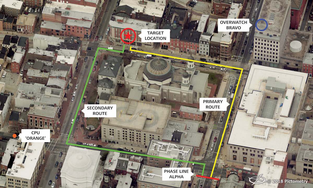
Difficulties related to object recognition in orthogonal imagery result in a lack of actionable intelligence for first responders or military personnel deployed to conflict zones. A soldier on patrol in a village would extrapolate limited information from an orthogonal image and may fail to answer critical questions such as:Location information is pertinent to the safety and planning of a domestic or international mission. The loss of perspective seen in orthogonal imagery is a problem that can be solved. Military and law enforcement personnel have discovered that oblique aerial imagery provides a viable solution to these challenges. Oblique imagery can be captured using the same platforms as orthogonal imagery, but instead of looking straight down, the sensor is angled at 40 to 45 degrees in order to capture a more natural perspective.
- What is the height of one building in relation to another?
- How high is the brick wall separating residences from roads and pathways?
- Where might an enemy shooter find the high ground on top of a structure?
- Is a wall high enough to protect a vehicle or a patrol from a potential blast or rocket attack?