When disaster strikes, county governments play a crucial in responding to and mitigating emergencies. While no community wants a crisis scenario to occur, being prepared and having the right technology in place can make a difference.

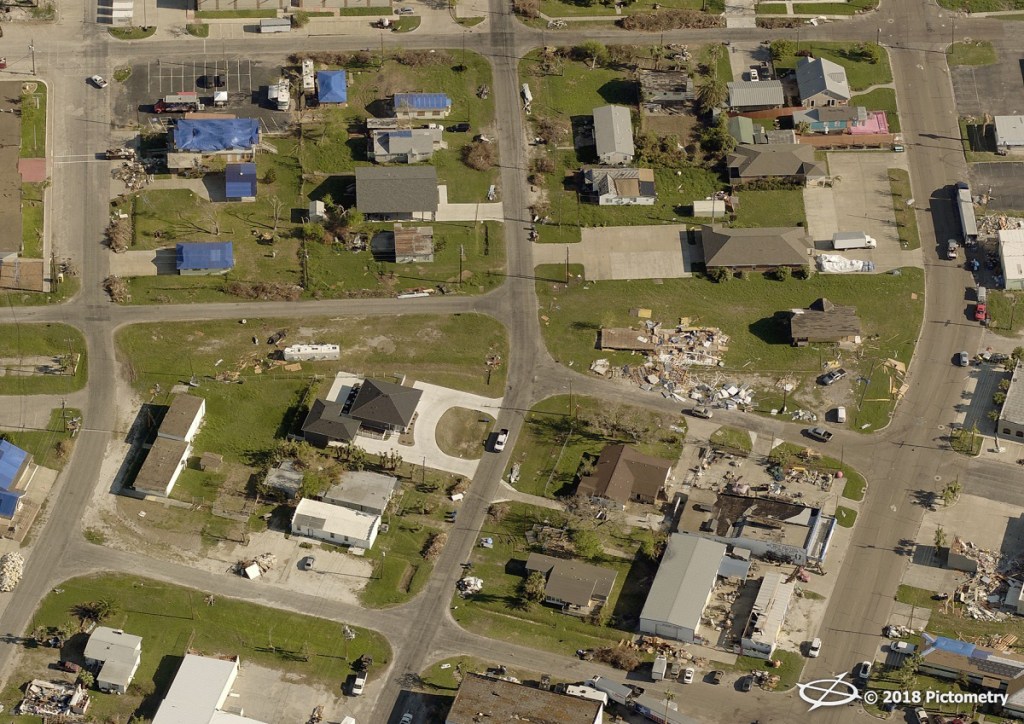
Imagery of a Texas neighborhood after Hurricane Harvey.
Assessing damage after a catastrophic event
Following Hurricane Harvey in the summer of 2017, communities in Texas had to mitigate one of the worst natural disasters to affect the United States.
Mike Soto, Chief Appraiser for Aransas County, Texas, shared the lessons learned following Harvey at the
2018 GIS/CAMA Technologies Conference. Aransas County is on the coast, just northeast of Corpus Christi, Texas—one of the hardest hit areas of Texas during the hurricane.
In his presentation, Soto explained the effects of the storm. The hurricane raged over the county seat, Rockport, for 13 continuous hours. For a time, the area saw 150 mph winds. Structures throughout the county saw significant damage, including the Aransas County Appraisal District office. High winds tore the front quarter of the building off and displaced Soto’s office.
EagleView
®, formerly Pictometry
®, operates a disaster response program which includes a no-cost flight for current
EagleView imagery customers who experience qualifying events. This post-event image capture is included in their contracts. Many counties, such as Aransas County, took advantage of this program in a year of unprecedented natural disasters.
Pre- and post-event EagleView imagery helped Soto and his staff of nine. With just four
appraisers in the Texas county, Soto and his team needed to develop a system that would help them view and rate the more than 29,000 parcels throughout the county.
The
results were devastating.
“We had 25% of the structure value lost as the result of Harvey,” Soto said.
In the early weeks following Harvey, Soto’s office needed to relocate. For the first two weeks, the county lacked running water; residents also had no reliable electricity or internet connectivity for three weeks. Aransas County appraisers took their server with them and worked out of a makeshift building, powered by a generator.
Soto’s office contacted EagleView right away. “This was coordinated the day of the storm,” Soto said of the flight.
EagleView organized flights
as soon as airspace opened up. “Eight or nine days after the storm they were in the air—as soon as they had clear skies,” Soto said.
With the help of EagleView imagery, Soto’s office was able to review all structuralized parcels and segments within eight weeks of the hurricane.
In a typical appraisal cycle, the Aransas County Central Appraisal District would only see about 400 to 500 new builds or improvements in all 29,000 parcels. Following Harvey, however, Aransas County appraisers discovered that nearly half of the county’s structures saw at least 25% damage.
How could the appraisers work quickly to document the effects of the hurricane?
“We used the tools and technologies that were available to us,” Soto explained.
Machine learning is helping EagleView spot property changes, including that from post-event damage. This powerful
change detection solution can be used in the event of a crisis or during the reassessment cycle to spot significant property updates.
Top lessons for disaster management
A view of Rockport, Texas, in Aransas County days after Hurricane Harvey touched down.
At the end of his presentation at GIS/CAMA, Soto imparted his top takeaways from the storm:
1. Scan all archived documents.
Having backups in the digital age is crucial for government agencies. Soto advised intentionally keeping this data in other locations in case of a disaster.
2. Ask yourself the tough questions.
Soto didn’t think he would have to talk to residents about total losses in the weeks leading up to Hurricane Harvey. Assessors and appraisers should ask themselves tough questions about appraisal scenarios before a disaster might strike.
3. Understand the human element of a disaster.
Interacting with the public after a catastrophe takes an emotional toll. Soto reminded the audience that government employees are community members, too. They might also be facing personal losses and other issues following an event.
4. Build relationships with other agencies.
Soto told the audience to reach out to nearby local agencies, especially those that use EagleView imagery. This gives assessors and other government officials resources in times of crisis as well as during business as usual.
5. Consider cloud solutions.
This goes back to point number one. Cloud storage helps back up data in more than one location.
Helping communities after a storm
Aransas County is rebuilding after Hurricane Harvey. With EagleView imagery, Soto and his staff can keep tabs on the progress the county is making.
Machine learning is helping EagleView spot property changes, including that from post-event damage. This powerful change detection can be used in the event of a crisis or during the reassessment cycle to spot significant property updates.
Government agencies require a variety of solutions not only to mitigate disaster but to stay on top of change. Today, more than
1,500 counties rely on EagleView to provide them with this data.

To date, EagleView has provided disaster response imagery after more than 50 events.
See where EagleView has provided imagery following natural disasters and catastrophic events.