Challenge
Emergency responders in Roanoke County, Virginia, needed to locate and rescue a hiker in distress along the Appalachian Trail.
Solution
Search-and-rescue crews used EagleView imagery (formerly Pictometry) to verify the location of the hiker, find a private road for access, and measure distances to plan their rescue.
Located in the historic Roanoke Valley, Roanoke County, Virginia, boasts 22 scenic miles of Appalachian Trail. With a population of 92,000, the municipality is one of the largest in Southwest Virginia and the commercial and cultural hub of much of Southwest Virginia.
As Roanoke’s Battalion Chief, Tom Bier had been a part of many rescues and
emergency situations. Working with 160 career emergency response professionals and more than 200 volunteers, Bier had developed systems for success that have not only made a difference to the emergency response teams but continue to save lives.
In 2013 alone, the region experienced more than 14,000 calls for service. One very memorable call came in on August 8, 2013, at 6:49 p.m.
“Our Emergency Communication Center received a cell phone call from a group of hikers stating that one of the group, a 13-year-old female, had fainted and was unresponsive and shaking,” Bier said. “It was a cool day for August and a cold front just passed with some thunderstorms. The patient was cold, wet, and dehydrated.”
There was some confusion as to their exact location as the caller indicated that they were a mile from the Dragon’s Tooth parking lot on the North Mountain Trail.
“We frequently respond to calls on the Dragon’s Tooth section of the Appalachian Trail but were unfamiliar with the North Mountain Trail,” continued Bier. “With a command post established in the Dragon’s Tooth parking lot and a report that one of the guides was hiking out for help, it was decided to wait until that person made it to the command post to determine the best course of action.”
One of the systems that Bier would utilize was PictometryOnline™, which has since been updated to
CONNECTExplorer™. This web-based imagery visualization and mapping software features EagleView imagery specifically captured for the county. Using the imagery and analysis tools, Bier’s team would easily be able to measure distance from the patient to a private road, identify ownership of parcels and determine overall condition of terrain. The imagery quickly became an invaluable tool for county personnel when they needed to locate areas that were not easily accessible.
“While waiting, we Googled ‘North Mountain Trail – Appalachian Trail’ and discovered it was an old section of the Appalachian Trail nearby,” Bier explained. “Our emergency communication center (ECC) had provided the command post with a phone number of the caller and the command post requested the caller dial 911 again in the hopes of getting some GPS information from the call. The ECC provided the command post with latitude and longitude coordinates.”
Bier and his team used EagleView imagery and data from EagleView to review the information. “It indicated the subject was not on the Dragon’s Tooth system but on the ridge of a nearby mountain,” he said. “The guide made it to the command post and verified the location.”
A recon team of two rescuers were sent in via the trail the guide used. In the meantime, a private road on the other side of the mountain was viewable within EagleView imagery. With the recent heavy rains, the team did not know the status of this private road and used the data to obtain owner information and make contact.
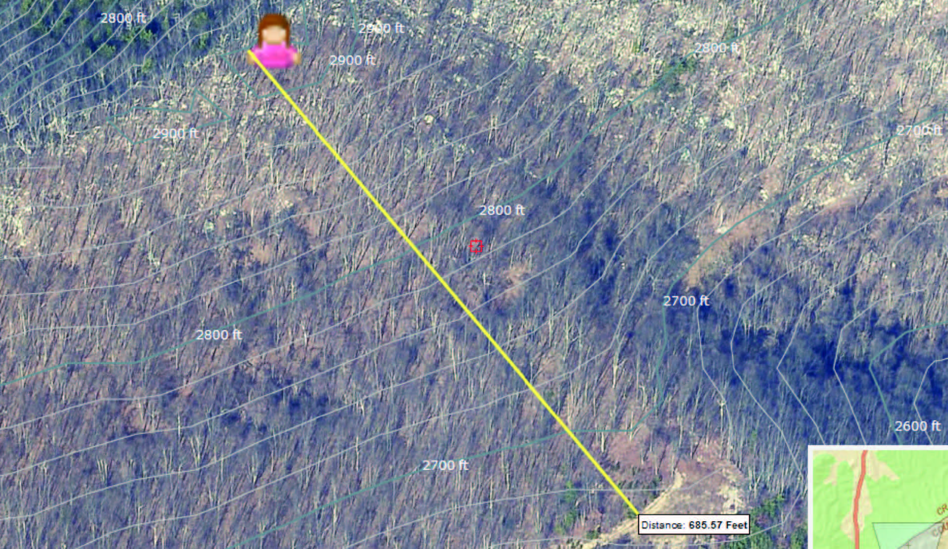
The owner came to the command post and indicated that the road was accessible to a point near the indicated position. Using measurement tools with EagleView imagery, they determined the road was 600 feet from the position and 250 feet below the ridge. Considering that the recon team had taken over an hour to make the hike to the patient, personnel decided to send a team with an SUV, pickup, and UTV up the private road.
After cutting their way in with a chainsaw, they were able to get the SUV within a quarter-mile to a washed-out portion of the road. The UTV was able to make it by the washout and crews hiked up from the road to the patient.
The young girl was packaged and carried to the UTV and then transported to the SUV for a ride off the mountain to an awaiting ambulance at the paved road. It took the recon team over an hour to reach the patient via the trail. With the information EagleView imagery provided, the rescue team of seven was able to reach the patient in less than an hour and then it was less than an hour to get the patient off the mountain and into an ambulance.
EagleView imagery, Bier said, “allowed us to verify the location of the patient, identify a nearby road to use for access, and identify the owner of the road. Without [the imagery], we probably would have carried the patient out via the trail and that would have taken several hours and at least twice the number of rescuers. It allowed us to cut in half the time it took to get the patient off the mountain and to the hospital.”
Roanoke emergency services also uses EagleView imagery for Pre-Incident Surveys, measuring features and identifying landowners during wildfires and overall rough triage of structures. They have also used this technology with SWAT incidents, providing the police officers with detailed pictures of the area and owner information for nearby properties.