
For roofers, winter can be a slow season for business. However, the cold can give business owners the opportunity to evaluate their services and
reach out to homeowners at local events.
To keep busy
during this time of year, roofers, landscapers, and other contractors may take on other projects. In snowy regions, snowplowing is a much-needed service for home and business owners.
How do contractors find the right customers? Their data makes a difference.
Sure, it’s possible to use a street map or even low-resolution satellite imagery to find locations and plan routes. But with better imagery, snowplow operators have all the details they need.
EagleView provides contractors with property measurements in
EagleView reports. Those measurements come from high-resolution
Pictometry® aerial imagery, which shows properties from the top-down and from an
oblique perspective in all four cardinal directions.
CONNECTExplorer™ from EagleView enables users to view and analyze Pictometry imagery. CONNECTExplorer includes several measurement tools, many of which can help contractors prospect and plan for winter. These four must-haves tools in CONNECTExplorer for snowplow operators are:
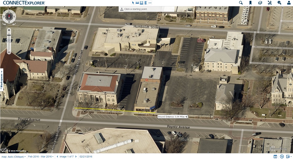
Ground distance
Roofers who order EagleView reports receive the length, height, roof pitch, and other measurements of a structure. Pictometry imagery from EagleView makes that precision possible. Each pixel in Pictometry imagery is georeferenced, meaning that it corresponds to exact latitude/longitude coordinates.
In CONNECTExplorer, users can measure distances in the locations shown in Pictometry imagery. This can help snowplow contractors plan their routes and gather information about a neighborhood before the snow hits.
Ground slope
Roofers know that they have to be careful when it comes to steep slope roofs, which require additional safety precautions on the job. EagleView reports feature
roof pitch calculations, so contractors can always gauge the difficulty of a project before it begins.
Just as roof slope can be calculated on Pictometry imagery, the same goes for ground slope on terrain. Some properties may have flat, easy-to-plow driveways. But other driveways in a neighborhood may be much steeper. The ground slope tool in CONNECTExplorer enables plow operators to figure out which driveways will pose challenges in extreme weather.
Identify
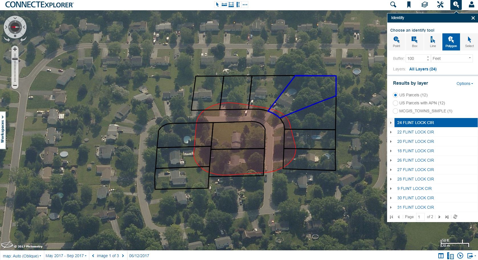
Without knowing an area well, a snowplow driver could travel a long distance just to plow for one customer. Yet with the right information, this contractor could advertise to that customer’s neighbors, too.
The identify tool in CONNECTExplorer lets users select a point or create a polygon shape around an area to identify one or more parcels. By adding a “buffer” around the point or polygon, users receive the addresses and data for multiple parcels.
The parcel data can be exported into a spreadsheet for easy reference and sorting. That information is a must-have for contractors who want to send out direct mail advertisements or go door to door visiting prospects in the fall.
Annotation
The annotation tools in CONNECTExplorer include shapes, lines, markers, and text. These tools enable users to document access issues, such as steep driveways, gates, busy main roads, or areas with street parking.
CONNECTExplorer users can return to this information later by saving their data as a workspace. Snowplow contractors could organize workspaces by the neighborhoods or communities they serve, and they can track existing customers versus prospects that way, too.
CONNECTExplorer for Public Works
 Contractors
 aren’t the only ones who can take advantage of the tools in CONNECTExplorer.
Public Works departments with access to Pictometry imagery can use the tools in CONNECTExplorer to plan routes for plowing public roads. The same tools that help contractors measure distances, calculate slope, annotate images, and identify parcels are available for users in government.
In areas with street parking, Public Works agencies can keep track of any alternate parking rules for that city or town. These are traffic laws that tell drivers where to park depending on the time of day or day of the week. Drivers must comply with these rules for effective snow removal.
By using the identify tool in CONNECTExplorer, Public Works departments can send notices to residents regarding alternate parking laws. They can also ensure that all fire hydrants are kept clear for emergency services if they have this GIS data from their jurisdiction added to CONNECTExplorer.
Try CONNECTExplorer!
Are you a contractor interested in using CONNECTExplorer for your business? Contact us for more information.
Is your agency using Pictometry imagery from EagleView? Contact your GIS administrator or IT department for access or talk to your EagleView representative about training and support. New to EagleView?
Contact us to start a conversation.