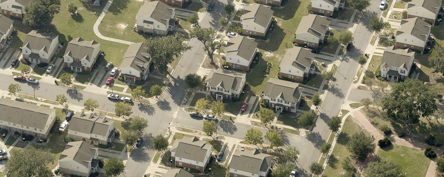
A modern aerial imagery program is more than a data collection exercise, it’s the foundation for smarter decisions, stronger resilience, and more efficient operations. For professionals using geospatial data in any capacity, imagery fuels nearly every aspect of planning, management, and public service.
An imagery program is a holistic, data-driven approach to acquiring, managing, and leveraging aerial imagery to support informed decision-making, operational efficiency, and strategic planning. It encompasses the entire lifecycle of imagery, from capture and processing to integration, analysis, and application of insights, ensuring that data is accurate, current, and ready to meet an organization’s evolving needs.
Eagleview Reveal® and Eagleview Vault™ provide this foundation: Eagleview Reveal delivers fresh, high-resolution imagery for day-to-day decision-making, while Eagleview Vault maintains a comprehensive historical record for comparison, analysis, and long-term insight. Together, they empower commercial entities and governments to build an imagery program that is reliable, scalable, and future-ready.
Why It’s More Than Just Imagery
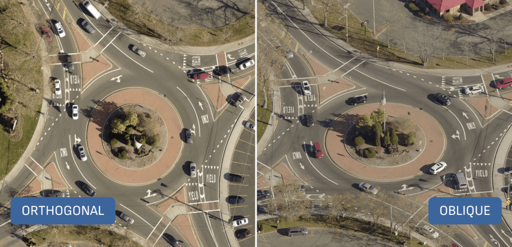
An imagery program is not simply about capturing pixels, it’s about creating a geospatial framework for action. When approached holistically, an imagery program capturing orthogonal and oblique imagery and data becomes a critical infrastructure for users to:
- Enhance situational awareness across public safety, disaster recovery, and infrastructure management.
- Drive efficiency by reducing manual fieldwork and enabling remote, data-driven inspections.
- Ensure compliance and accountability, supporting defensible, transparent decisions.
- Future-proof operations, scaling as needs evolve and technology advances.
This comprehensive approach is built on five key pillars: Capacity, Accuracy, Resolution, Frequency, and Licenses.
Capacity: Scalable Imagery for Every Need
Ensuring comprehensive coverage is essential for any statewide or regional imagery program. A scalable capacity framework allows commercial entities and governments to capture data across large, diverse geographies while maintaining accuracy and consistency.
Considerations:
- Comprehensive Coverage: Statewide or regional coverage ensures all communities benefit from consistent, actionable data.
- Efficient Data Collection: The right program minimizes time and resource demands without compromising accuracy.
- Flexible Scheduling: Adjust capture frequency and timing to meet project-specific needs.
- Future-Proofing: Scalable infrastructure supports growth without requiring new systems or workflows.
How Eagleview Helps:
With a fleet of more than 100 aircraft, Eagleview captures imagery across approximately 1 million square miles each year, representing about 25% of U.S. counties. Our imagery footprint extends even further through Eagleview Vault, which provides access to historical and current imagery covering 94% of the U.S. population and 65% of the population across the four most populated Canadian provinces.
This proven capacity enables Eagleview to deliver statewide, high-resolution imagery programs that scale effortlessly. Through Eagleview Reveal, customers can schedule multiple captures per year to support initiatives like development monitoring or emergency response. Eagleview Vault maintains long-term continuity by housing decades of imagery, empowering deeper insights and trend analysis. Seamless integration with Esri-based GIS workflows ensures imagery aligns with the systems professional rely on making Eagleview the scalable, future-ready choice for local, regional and statewide mapping initiatives.
Accuracy: Precision That Builds Trust
Accuracy is the cornerstone of a reliable imagery program. Decision-makers depend on precise, verifiable data to guide infrastructure planning, resource allocation, and public safety operations.
Considerations:
- Improved Decision-Making: Accurate imagery builds confidence in high-stakes decisions.
- Trusted Data: Verified imagery ensures alignment with GIS layers and analytical models.
- Regulatory Compliance: Accuracy supports adherence to state and federal standards.
- Risk Mitigation: Reliable data reduces costly errors and liabilities.
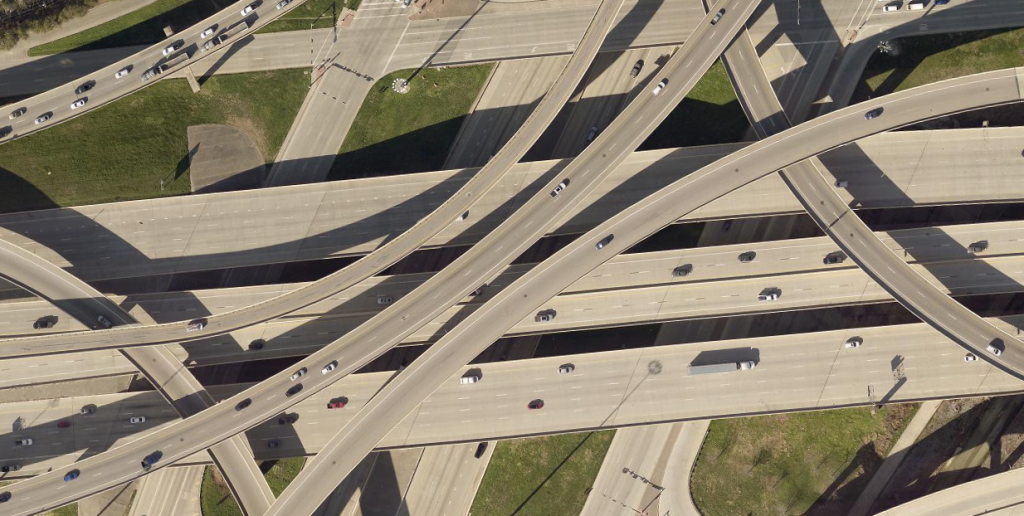 Eagleview Certified Orthomosaic, High Five Interchange (Dallas, TX)
How Eagleview Helps:
Eagleview’s imagery can be certified to meet or exceed national accuracy standards, verified by licensed surveyors, engineers, and photogrammetrists. Through the use of more than 20,000 ground control points (GCPs) nationwide, our imagery achieves required positional accuracy.
For governments that need the highest possible fidelity, Eagleview Reveal offers exclusive access to 1-inch (2.5 cm) GSD imagery, providing unparalleled clarity and detail. Certified orthomosaics and a documented photogrammetric workflow ensure every dataset is defensible, trustworthy, and ready for integration into regulatory and assessment frameworks. Review Eagleview’s accuracy statement here.
Resolution: Seeing What Others Miss
High-resolution imagery doesn’t just provide clearer visuals; it delivers exponentially more data for analysis and decision-making.
Considerations:
- More Detail for Better Insights: 1-inch (2.5cm) imagery reveals critical details invisible at coarser resolutions.
- Enhanced Predictive Modeling: AI and ML models become more accurate with denser pixel data.
- Change Detection: Subtle shifts in land use or infrastructure become measurable.
- Support for Complex Projects: Urban planning, environmental monitoring, and emergency response all benefit from precise, detailed imagery.
1 inch Imagery
3 inch Imagery
How Eagleview Helps:
Eagleview’s 1-inch (2.5cm) GSD imagery provides 9× more data than 3-inch imagery and 140× more than most commercial satellite imagery. This density supports advanced applications, from AI-powered analysis like change detection to risk modeling and asset identification.
With Eagleview Reveal, users gain the clarity needed to analyze terrain, infrastructure, and assets with exceptional accuracy fueling smarter planning, faster response, and better long-term forecasting.
Frequency: Keeping Pace with Change
Change is constant as urban growth, environmental shifts, and natural disasters all reshape the landscape. Frequent imagery updates ensure that governments always have the most current, actionable data available.
Considerations:
- Up-to-Date Data: Frequent captures maintain current ground truth.
- Change Detection: Regular updates reveal growth, risk, and compliance patterns.
- Disaster Preparedness: Pre- and post-event imagery accelerates response and recovery.
- Urban Growth: Frequent updates support zoning, planning, and infrastructure management.
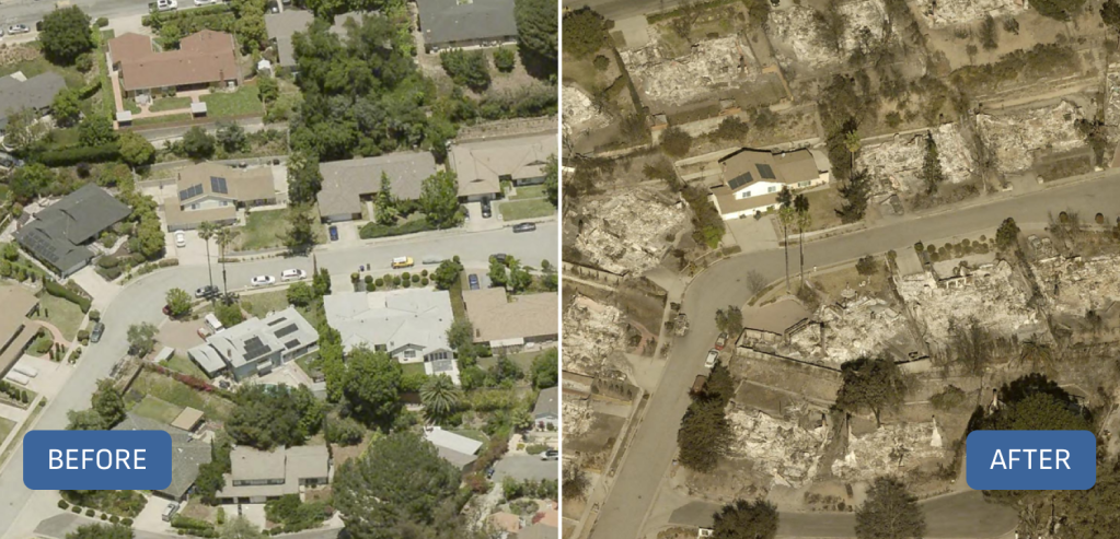 Eagleview post-disaster imagery of the Los Angeles Wildfires (Altadena, CA)
How Eagleview Helps:
Eagleview’s Metro Capture Program captures annual imagery of the Top 100 metros in the U.S. and Canada, ensuring that the fastest-growing regions remain accurately mapped. Frequent imagery enhances automated change detection, helping governments quickly identify unauthorized construction, land use violations, or damage to public assets. When disasters strike, the Eagleview Disaster Response Program delivers rapid post-event imagery for emergency response and recovery. Eagleview Reveal keeps imagery current, while Eagleview Vault provides historical context for comparison. Together, they create a complete view of change over time.
Licenses: Ensuring Trustworthy Data
Licensed professionals are essential to maintaining the integrity of an imagery program. Their validation ensures that every dataset meets legal, regulatory, and ethical standards.
Considerations:
- Expert Validation: Licensed surveyors, engineers, and photogrammetrists confirm data reliability.
- Regulatory Compliance: Certified imagery supports legal defensibility and adherence to standards.
- Public Trust: Certified data fosters transparency and confidence in government decision-making.
- Risk Reduction: Properly certified data minimizes exposure to legal or financial challenges.
How Eagleview Helps:
Eagleview employs Professional Engineers (PEs), Professional Land Surveyors (PLSs), and Certified Photogrammetrists (CPs) who oversee the accuracy and precision of every imagery project. With multiple state licensures and ASPRS-certified professionals, Eagleview ensures compliance with both national and state-level standards for photogrammetry and mapping.
This licensed oversight provides governments with certified accuracy they can trust, building credibility with constituents, auditors, and regulatory bodies alike.
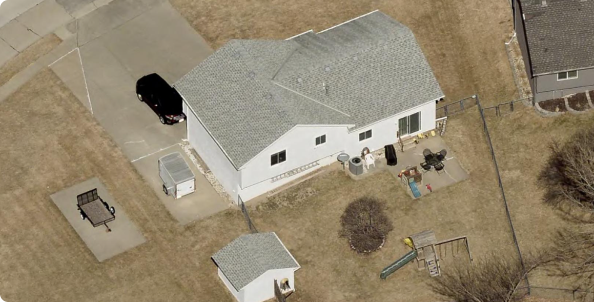
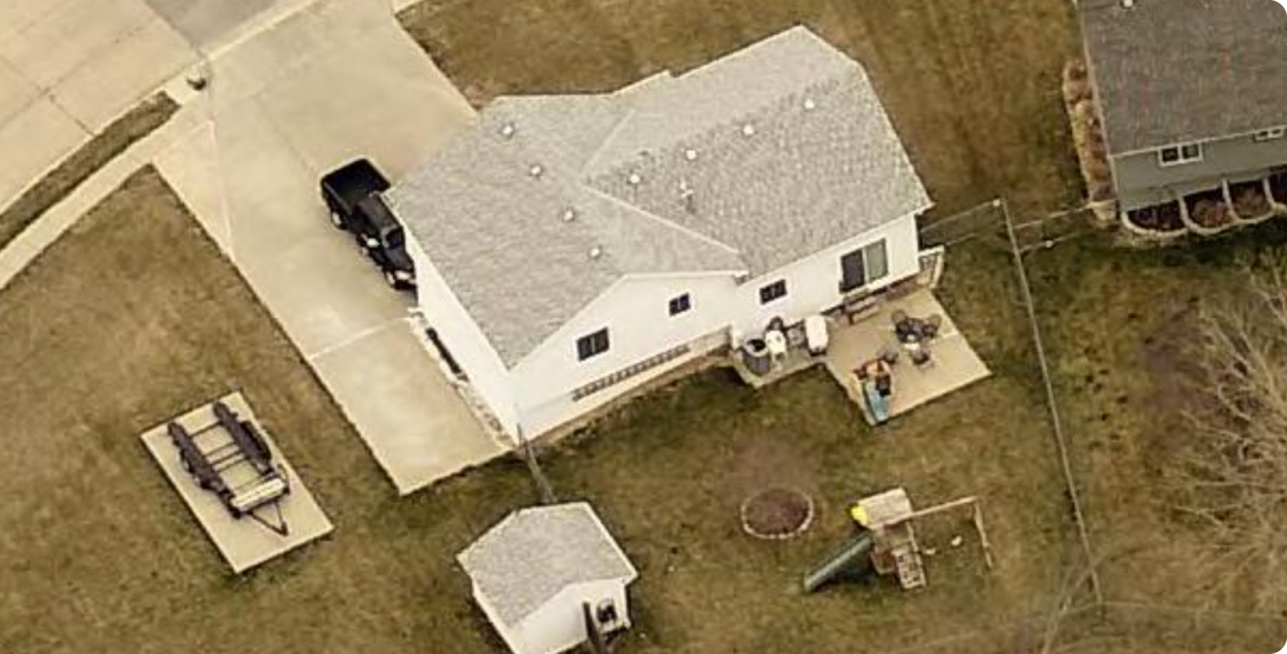
 Example of Eagleview Reveal 1-Inch GSD imagery
Eagleview Reveal + Eagleview Vault: The Foundation of a Complete Imagery Program
A resilient imagery program balances recency and continuity by prioritizing fresh captures to keep pace with change and historical archives to measure progress over time.
Eagleview Reveal ensures that you always have access to the most current imagery, captured at industry-leading 1-inch (2.5cm) resolution, while Eagleview Vault preserves that imagery for the future, creating a secure, searchable archive of every pixel ever captured.
Together, they form the backbone of a modern, scalable, and defensible imagery program—one that empowers governments to make faster, more confident decisions and build stronger, more resilient communities.
Discover how Eagleview Reveal and Eagleview Vault can help your organization build a complete imagery program.
Schedule a demo today.