
Written by Travis Clemens, Director of Imagery Products
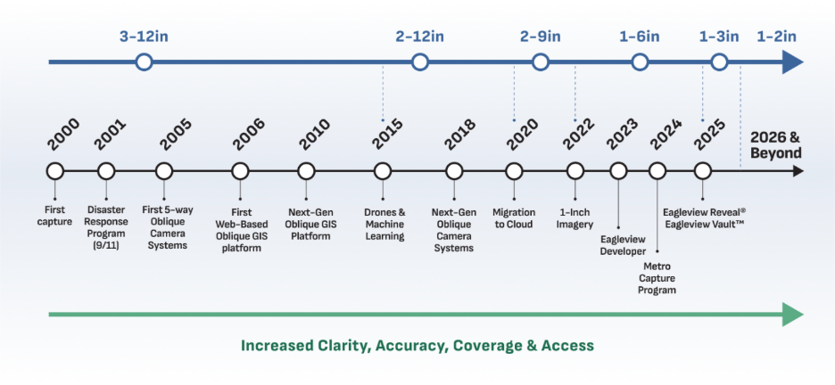
For more than 20 years, Eagleview has captured high-resolution aerial imagery at scale. What began in the early 2000s as a camera-in-a-plane operation has evolved into a continuously refreshed geospatial data platform designed for both human analysis and machine learning.
At a high level, Eagleview provides:
- A massive, living aerial imagery library leveraged by customers for comparison, analysis, and long-term insight: Eagleview Vault™.
- Comprehensive capture programs that focused frequency in the U.S. and Canada, along with covering disasters: Metro Capture and Post-Event Capture.
- Image capture subscription that keeps your imagery current year after year: Eagleview Reveal®.
- Developer APIs enable access to Eagleview imagery programmatically through a state-of-the-art API platform: Developer portal.
Understanding how those layers fit together is key to using Eagleview as a developer.
The Foundation: Eagleview Vault
Eagleview Vault is Eagleview’s continuously growing imagery library. It contains more than 25 years of high-resolution orthogonal and oblique aerial imagery covering 94% of the US population and 65%+across Canada. Eagleview’s basemap represents over 1.6M unique square miles. Eagleview captures more than 600,000 square miles annually of new and refreshed imagery into the Vault.
New imagery is added daily, which means Vault is not a static archive. Instead, it is a living spatial timeline of the built world.
All of Eagleview’s imagery products and APIs are powered by this underlying dataset.
How Vault Stays Fresh: Capture Programs
Metro Capture
The Metro Capture program ensures that major urban areas across the U.S. and Canada are refreshed at least annually (often more frequently).
These are the areas with:
- Dense populations
- High commercial and residential property density
- Rapid construction and asset turnover
Metro Capture makes it possible to analyze change over time, such as new construction, redevelopment, infrastructure growth, and urban expansion because you can compare current imagery against prior years for the same location.
For example, customers can track the full construction lifecycle of a project like SoFi Stadium by pulling multiple time-stamped captures of the same site.
Post-Event Capture (Disaster Response)
Eagleview also executes a post-event capture program that activates when major natural disasters or large-scale events occur.
This program began with Eagleview’s support of recovery efforts after 9/11 and continues today. In 2024 alone, Eagleview flew more than 60 disaster response missions, capturing over 10,000 square miles of impacted areas.
Post-event imagery provides:
- Pre-event vs. post-event comparisons
- Structural and environmental damage visibility
- Extremely high-detail images for insurance, utilities, government, and emergency response
This imagery becomes part of Eagleview Vault, making it accessible historically and programmatically through Eagleview’s APIs.
From Data to Action: Eagleview Reveal
Eagleview Reveal delivers Eagleview’s highest-resolution commercial imagery, optimized for visual inspection, analytics, and AI-driven workflows.
Reveal does this by using Eagleview’s most advanced camera systems, highest-resolution flight profiles, and multi-angle (ortho + oblique) capture patterns.
It then applies Eagleview’s proprietary post-processing system and quality-control rigor to produce a premium, validated imagery product.
With an annual refresh at 2-inch GSD and the option to upgrade to Eagleview’s industry leading upgrade to 1-inch GSD imagery, Eagleview Reveal provides a dependable foundational imagery product to support your workflow and that you can trust, year after year.
Where Developers Come In: The Imagery API
The Imagery API is how developers access Eagleview Vault programmatically. Through the API, developers can:
- Specify an Area of Interest (AOI)
- Request orthogonal or oblique imagery
- Retrieve historical imagery
- Access post-event captures
- Integrate imagery into their own applications, analytics pipelines, or AI models
Our robust developer portal makes it easy to go from idea to API calls, with free sandbox access and a free Imagery API Trial, supported by comprehensive docs, guides, and Postman collections.
What High-Resolution Actually Means
Eagleview’s imagery is captured at resolutions as fine as sub-1-inch per pixel. At that level of clarity, users can identify:
- Individual property features
- HVAC units
- Street signs
- Tower equipment
- And even objects as small as a golf ball
This matters not just for human inspection, but for machine learning, asset modeling, and automated analysis, where fine-grained visual detail dramatically improves detection and classification accuracy.
Why This Matters for Developers
Eagleview imagery is not just something you look at; it is something you build on.
By combining:
- High-resolution ortho + oblique imagery
- Multi-year imagery coverage for the same location
- Metro-level refresh cycles
- Post-event data
- And APIs that make it all programmable
Developers can create applications that:
- Detect change
- Monitor assets
- Assess damage
- Train AI models
- Automate inspections
- Power underwriting, construction, utilities, energy, and insurance workflows
The challenge, and opportunity, for developers is no longer “Can I get imagery?” It is: “How much intelligence can I extract from every pixel?”
We encourage you to leverage our free Sandbox to get started interacting with the Imagery API right away. But if you'd like to explore imagery in an area that's meaningful to you, please sign up to secure your spot in our limited trial program.
Questions? Reach out to developerfeedback@eagleview.com at any time.