Written by Dimitri Volkmann, Eagleview One Product Marketing
In October, we launched the Eagleview One Flight Meetup Webinar Series, a recurring, hands-on event for the Eagleview community. These meetups are intentionally casual, interactive, and practical, focusing on live demos, real-world use cases, customer stories, and open Q&A. The goal is simple: help users get more value from Eagleview One, high-resolution imagery, and geospatial intelligence.
Below is a recap of our 2025 episodes and the key takeaways from each.
Episode #1: Introducing the Eagleview One Property Viewer
Theme: Unified property intelligence in one interactive experience
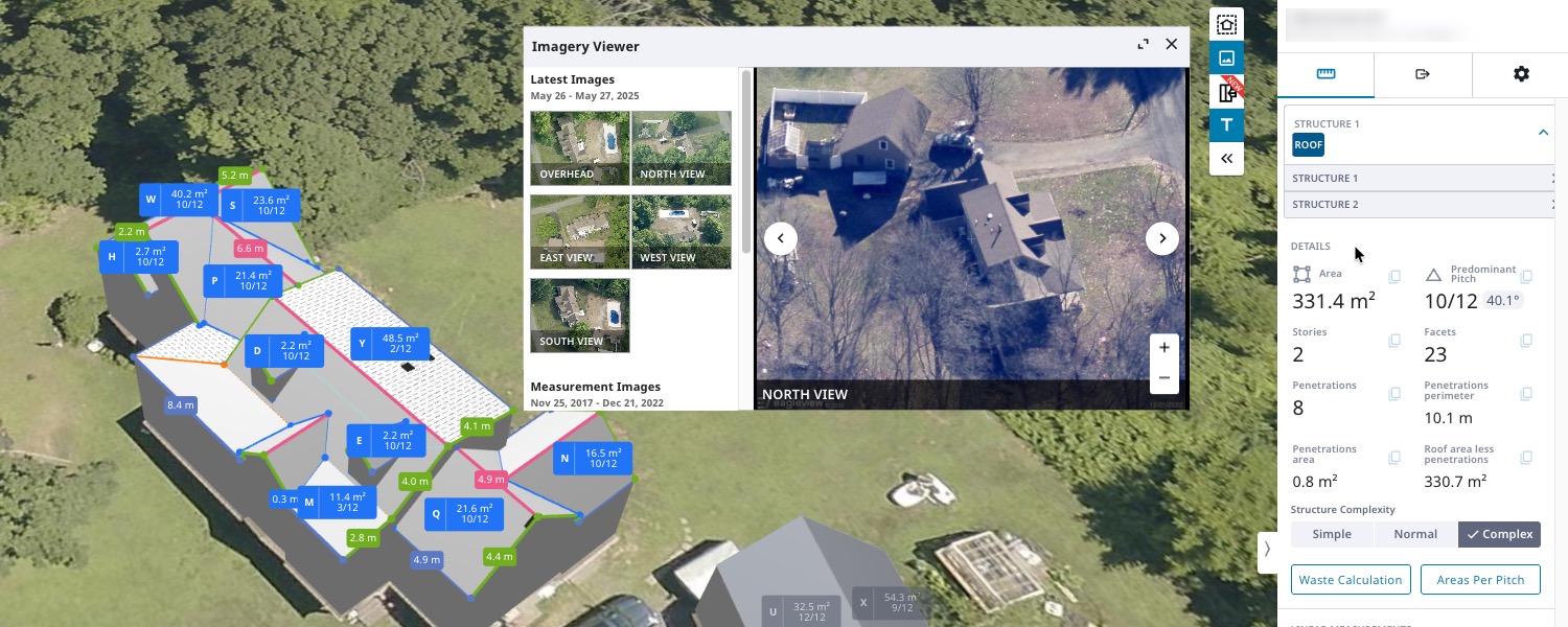
Our first live meetup introduced the Eagleview One Property Viewer, an intuitive way to explore imagery, 3D models, measurements, and property data in a single interface. Attendees saw how Eagleview has evolved from trusted aerial imagery and PDF measurements into a unified geospatial intelligence platform that makes it easier to contextualize and act on property data.
Key highlights:
- A single, interactive experience for imagery, 3D models, measurements, and property data
- Evolution from static PDFs to dynamic, actionable geospatial intelligence
- Live demo showcasing 3D model rotation, layered imagery, and fast, precise measurements
- Real-world workflows from Jeremy Blount (Professional Roofers), including:
- Complex multifamily insurance claims
- Partial roof replacements
- Improved residential quoting accuracy
Episode #1 is available on demand, along with a detailed recap blog.
Episode #2: Powering the Next Generation of Apps with Imagery APIs
Theme: Bringing Eagleview imagery into custom applications
Episode #2 shifted focus to developers and innovators, highlighting how Eagleview’s high-resolution imagery catalog and Imagery APIs can be used programmatically to power modern, data-driven applications.
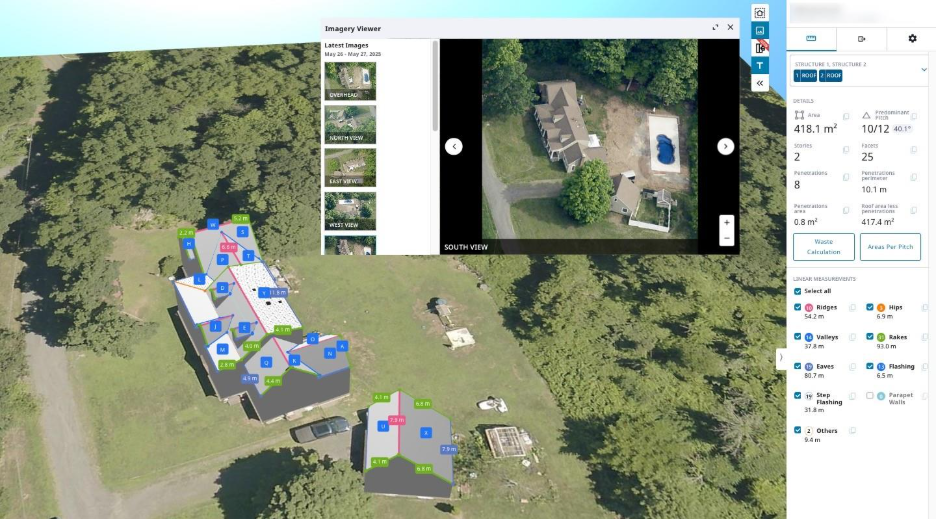
 Example of a high-resolution oblique imagery available using the API
Key highlights:
- Overview of Eagleview’s imagery catalog and developer tools
- Live demos showing how to:
- Access imagery quickly
- Integrate imagery into workflows
- Move from sandbox exploration to production
- Customer spotlight from PropertyFi, demonstrating how Eagleview imagery supports:
- Advanced geospatial analysis
- Machine learning workflows
- Next-generation geospatial tools
- Launch of the Free Trial Early Access Program
Thank you to Corey Decker (Co-founder & CEO) and Kyle Starkes (Solution Engineer) of PropertyFi for sharing their experience.
Episode #2 is available on demand.
Episode #3: The Property Data Episode
Theme: Turning imagery into actionable property intelligence
Episode #3 expanded the series by focusing on AI-powered property and roof attributes derived from Eagleview’s imagery and analytics pipeline. Attendees explored how these insights are delivered through Eagleview One Apps, APIs, and reports to support faster, more informed decision-making.
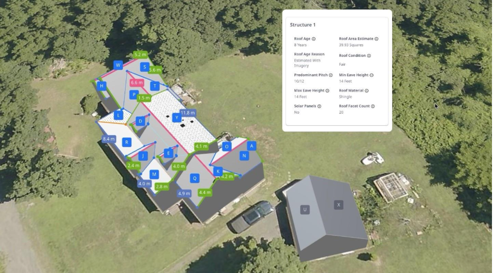 Basic roof property data example
Key highlights:
- How AI-driven property data is delivered through:
- Eagleview One applications
- APIs
- Reports
- Use cases across construction and insurance, including:
- Faster prospecting
- Improved pre-inspection accuracy
- Full API demo with hands-on coding examples
- Customer conversation with Jeff Wisniewski (CEO, CutterCroix) and Paul Selby (Eagleview) on how GiddyUp delivers contractor-focused solutions using Eagleview data
- Live Q&A with practical guidance for applying property intelligence across industries
Episode #3 is available on demand.
Looking Ahead to 2026
In 2026, the Eagleview One Flight Meetup Webinar Series will continue to focus on practical, real-world content, including:
- New features in the Eagleview One Property Viewer
- Enhanced user experiences across imagery tools
- New solutions powered by geospatial data and AI-driven insights
- Brand-new apps that extend property intelligence into additional workflows
Eagleview will continue delivering insights that help construction, insurance, government, utilities, and emergency management teams work smarter, faster, and with greater confidence using geospatial intelligence.
Join Us at IRE 2026 — and Don’t Miss Episode #4
Eagleview will be exhibiting at International Roofing Expo (IRE) 2026. If you’re attending, visit us at booth #2953 to connect with the team and see what’s new.
Shortly after the show, Episode #4 of the Eagleview One Flight Meetup Webinar Series will air on January 29, featuring insights inspired by IRE. We'll preview new, upgraded features in our 3D models — including walls, windows and doors measurements.
Register for Episode 4 and let’s keep flying higher together in 2026.
_____
Watch On Demand Anytime
Missed a live session or want to revisit a specific demo? All episodes of the Eagleview One Flight Meetup Webinar Series are available on demand in our Webinar Hub.
Watch anytime at: eagleview.com/webinars