Learn how oblique aerial imagery can help Public Safety departments preserve life and property.
Keeping Communities Safe Is a 24/7 Challenge
Public Safety departments—including first responders, 911 dispatchers, and emergency management teams—play a crucial role in keeping our cities and counties safe. They are responsible for ensuring the welfare of both life and property and are expected to respond quickly and effectively at all hours and in all conditions.
When time is of the essence and lives are at stake, visibility is critical. Public Safety teams must be able to access and share accurate location information, site details, and comprehensive situational data. Relying on inefficient analog tools or outdated satellite imagery simply isn’t an option.
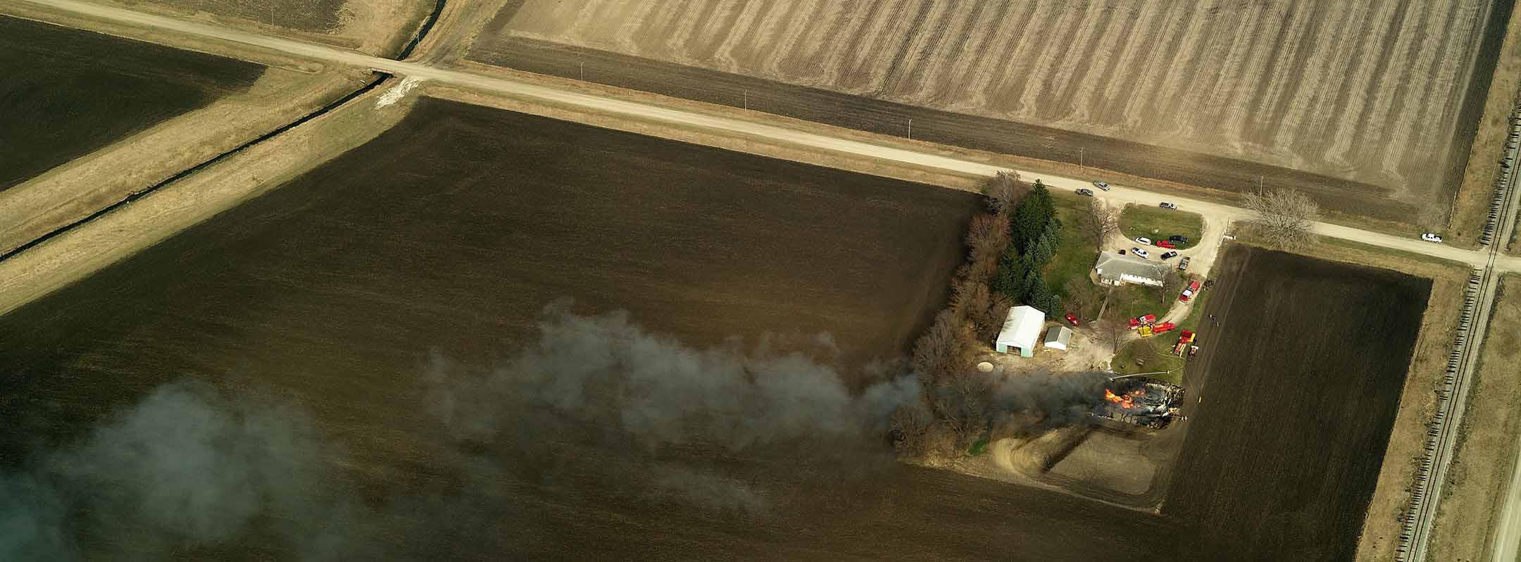
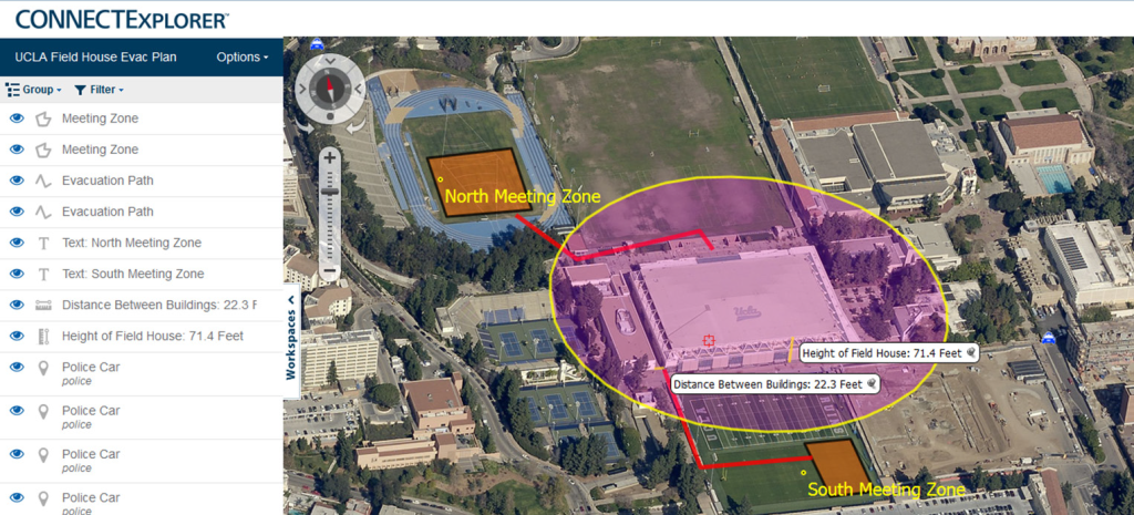
Aerial imagery can be used to identify threats to responding personnel. In this case, a dispatcher could see two tanks adjacent to a burning building, one of which was obscured by smoke and a potential hazard to first responders.
 Note: EagleView happened to be capturing new aerial imagery while this fire
was in progress; EagleView does not capture aerial imagery during fires.
EagleView's Oblique Aerial Imagery Can Help
EagleView’s oblique (side-angled) aerial imagery provides 911 dispatchers, law enforcement, fire and rescue, and disaster planning teams with the visibility and insights needed to plan, prepare, and respond to emergencies and catastrophic events—while ensuring the safety of both emergency response personnel and the public they serve.
EagleView’s oblique imagery is taken at a 40-to-50-degree angle from low flying aircraft equipped with a camera system that rapidly captures images from all cardinal directions, providing up to twelve angles of a single location, and enabling comprehensive views of buildings and surrounding property.
These perspectives can then be combined to provide additional context and insight that could not be achieved by orthogonal (top-down) imagery alone.
With EagleView’s high-resolution oblique aerial imagery, Public Safety teams can:
- Accurately locate callers, allocate resources and reduce response times during emergencies.
- Gain clear visibility of incident locations with daytime imagery that’s free from debris, smoke, and water.
- Improve decision making with enhanced situational awareness and a better understanding of a location, scale, and severity of an incident.
- Assess and share potential hazards, help first responders take appropriate safety precautions, and reduce the risk of accidents and injuries.
- Facilitate effective communication, provide a common view of the situation, and enable better coordination between agencies.
This guide will explore the benefits of EagleView's oblique aerial imagery for Public Safety, including specific use cases for:
- 911 dispatch
- Law enforcement
- Fire and rescue
- Disaster planning and response
1. 911 Dispatch
Quickly Pinpoint a Caller’s Location
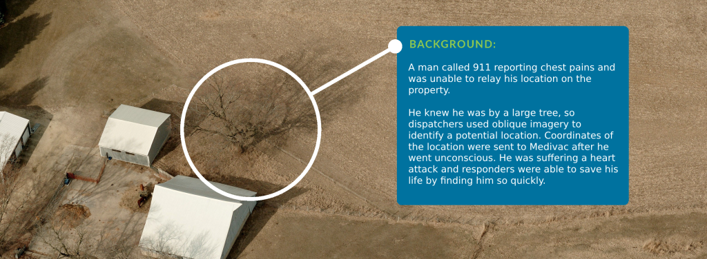
Today, the majority of 911 calls are made using cell phones, which can make it difficult to locate the caller’s precise location. However, using EagleView’s oblique aerial imagery, dispatch teams can gain access to the geographic intelligence and visual context needed to identify the exact location of a 911 caller.
By cross-referencing oblique aerial imagery and available cell tower data with the caller’s description of nearby buildings, signs, and other landmarks, dispatch teams can effectively narrow down a caller’s precise location.
Share Critical Site Details With First Responders
Having access to oblique aerial imagery also enables dispatchers to share critical site details with first responders to speed response and ensure their safety. Dispatch teams can use oblique aerial imagery to:
- Identify the fastest and safest route to the scene.
- Share geolocation data and aerial imagery with first responders while en route.
- Provide critical site details from multiple angles, including:
- Road access and location of electrical wires, walls, fences, gates, and other obstacles that might impair equipment, vehicle, or helicopter access.
- Building dimensions, door and window placements, and potential site hazards.
- Distances to resources like hydrants and other water sources.
2. Law Enforcement
Analyze Areas of Operation
EagleView’s oblique aerial imagery equips law enforcement teams with the insights needed to plan safer, more effective law enforcement operations by allowing them to:
- Review sites in advance before serving warrants or conducting SWAT raids.
- Analyze areas of operation and identify surveillance and staging areas.
- Visualize and inspect buildings and their surrounding areas in daylight and ideal weather conditions to identify potential threats and vulnerabilities.
- View structures and properties from multiple vantage points to determine lines of sight and operational perimeters,
- Identify access points and potential escape routes, and spot hazards that may not be visible from the ground.
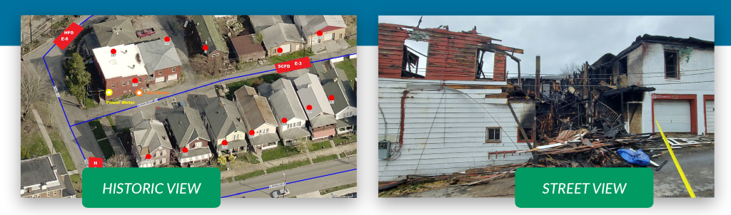
Visualize and Reconstruct Crime and Incident Scenes
Law enforcement teams can use oblique aerial imagery to visualize last known positions for missing persons and reconstruct crime scenes and vehicle accidents by overlaying evidence onto imagery. High-resolution oblique aerial imagery from EagleView also provides law enforcement teams with the ability to:
- Plan search and rescue missions.
- Provide pictorial references for court presentations and search warrant applications.
- Supplement statistics, charts, graphs, and maps to provide additional context for investigative work, as well as identify crime patterns and trends.
"EagleView is one of the first things the officers ask for. The dispatchers are able to pull EagleView up, look at the specific address, and actually lead officers where they need to go. And they're able to alert officers to any type of officer safety issues from the aerial imagery.”
Sergeant Steve Sommers
Mercer County Sheriff's Department
3. Fire & Rescue
Assess Incident Sites
Fire and rescue teams need to be able to respond to emergencies quickly and safely. Oblique aerial imagery provides fire and rescue teams with the ability to:
- Identify potential site hazards (e.g., propane tanks and other combustible material) which may not be visible during an active fire.
- Locate fire hydrants and other water sources, and plan placements for vehicles and equipment.
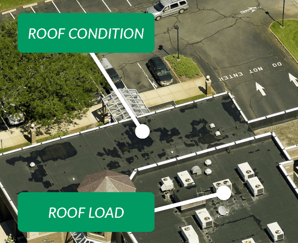
- Determine property layouts, structural composition, access points, and roof pitch.
- Visualize land contour to anticipate the impact of flooding and oil spills.
- Calculate the impact of changes in wind direction to determine the potential need for evacuation.
Pre-Incident Planning for Major Structures and Facilities
EagleView’s oblique aerial imagery offers the perspective and insights fire and rescue departments need to develop effective pre-plans, including the ability to:
- Measure building and property dimensions, as well as exact distances to water access and fire departments.
- Identify potential hazards on and around buildings (e.g., HVAC systems, water towers, etc.).
- Design response plans and conduct training drills without needing to be on location.
“I use EagleView to capture current and historic views for fire investigations.”
James Waterman
Capitan and Fire Marshal
4. Disaster Planning & Response
Preparedness
EagleView’s aerial imagery can aid disaster planning and response teams in recognizing high-risk scenarios, identifying vulnerability and risks, and effectively planning and preparing for disasters. High-resolution oblique aerial imagery provides you with the ability to:
- Visualize “what-if” scenarios, and prepare for disasters with clear and detailed visibility into potential risks.
- View both recent and historical oblique imagery with added enhancements including LiDAR, 3D Mesh, and Near Infrared capture to visualize vegetation density and condition, and identify areas at risk for flooding, wildfires, and other catastrophic events.
- Determine which areas may be made inaccessible during a flood or fire emergency, and plan alternative evacuation routes, traffic control, and relief staging areas.
- Model the potential impact from floods, anticipate the flow of water and material, and determine the number of sandbags and other supplies needed at specific locations.
Response
When a disaster strikes, it’s crucial that emergency response teams are able to respond promptly and effectively. EagleView’s oblique aerial imagery provides disaster planning and response teams with access to accurate information and insights needed to:
- Provide situational awareness to monitor disaster progress.
- Assist with command and control, evacuation, and rescue.
- Send coordinates of disaster areas to mobile and field command centers.
- Inspect structural damage hazards remotely to keep responders safe.
- Deploy human resources and disaster relief supplies to appropriate areas.
Mitigation
Emergency response teams can use EagleView’s oblique aerial imagery to identify potential threats and technological hazards with complete context to more effectively mitigate risks. With access to high-resolution oblique aerial imagery, teams can:
- Prioritize mitigation resources.
- Measure height, area, and width of buildings, as well as distance to resources and rescue assets.
- Conduct vulnerability analysis and threat assessments.
Recovery
Timely and accurate aerial imagery is an essential tool to help emergency response personnel quickly assess the severity of damage, analyze areas that aren’t yet accessible, and speed recovery efforts. With EagleView oblique aerial imagery, emergency response teams can:
- Compare pre- and post-imagery to develop recovery plans.
- Share oblique aerial image data with state and federal aid programs to expedite approvals, as well as with residents and business owners to assist with insurance claims.
All EagleView clients are eligible for our Disaster Response Program. In the unfortunate event of a disaster, EagleView will quickly capture new imagery at no additional cost to aid response and recovery. Qualifying events include:
- Hurricanes Category II and higher
- Tornados rated EF4 and higher
- Damage from terrorist attack
- Earthquakes 6.0 or higher on the Richter scale
- Tsunamis resulting in damage to critical infrastructure
“Our geography and other factors make us vulnerable to wildfires. We have acres of boreal forests, long winters and a dry climate. EagleView provides us with the images and information we need to make better and more informed decisions when dealing with emergency events.”
Justin Ngan
GIS Manager Regional Municipality of Wood Buffalo, AB
Integrate With Your Existing Workflows
Computer Aided Dispatch (CAD) Integration
EagleView integrates seamlessly with leading Computer Aided Dispatch (CAD) tools for 911 operations, augmenting your existing workflows and making it easy to view EagleView’s high-resolution oblique aerial imagery right within your existing software—without having to switch browser windows or manually search for an address.
Integrations are available for a variety of leading CAD platforms, including CentralSquare, GeoComm, Hexagon, Intrado, Motorola, and RapidDeploy. If an integration doesn’t exist with your platform, EagleView can work with your vendor to develop an integration to ensure high-resolution oblique aerial imagery is available to all personnel.
3D Mesh
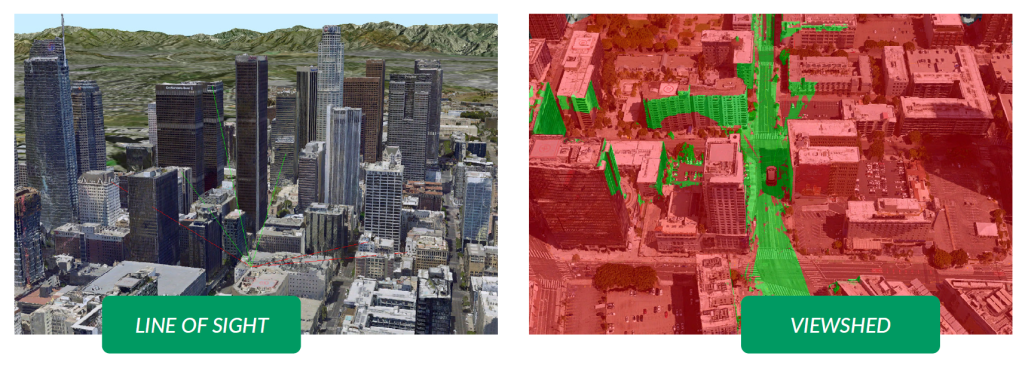
EagleView’s partnership with Skyline enables Public Safety teams to convert high-resolution oblique imagery into 3D Mesh layers and visualize geospatial data in a completely new way. 3D Mesh allows Public Safety teams to:
- View key structures, areas, and features in a 3D environment.
- Accurately measure distance, area, and volume.
- Visualize dynamic viewsheds and conduct line of sight analysis (e.g., when preparing for high profile events requiring optimal placement of law enforcement personnel to ensure visibility for the entire area).
- Enable floodplain analysis and water runoff path forecasting, assess land slope and drainage conditions, and conduct floodplain analysis to identify flood risks before they happen.
- View the most optimal and efficient route to a scene, and identify the path of least resistance for first responders (e.g., analyze elevation data and determine the most direct path with the least amount of slope, helping to avoid potential barriers or blocks which may not be visible in traditional imagery).
3D Mesh uses reference points in X, Y, and Z axes to define shapes with height, width, and depth, allowing you to view oblique aerial imagery in a 3D environment.
CONNECTMobile™
With EagleView’s CONNECTMobile™ app, users can access EagleView imagery on an Android or iOS-powered device - ideal for situations where users are in the field. Using the app, users can pan and zoom around the imagery, view and query parcel data, and overlay boundaries and streets to get a more comprehensive view of a structure or property.
Get Started Today
To learn more about how EagleView solutions can help meet your department's needs or to request a demo, visit https://www.eagleview.com/government.