Written by Dimitri Volkmann, Eagleview One Product Marketing
The first-ever Eagleview One Flight Meetup Webinar took off this month, marking the launch of a new recurring event series dedicated to showcasing Eagleview customers how to get hands-on with the latest features, tools, and data insights in Eagleview One.
Unlike typical webinars, these sessions are intentionally casual, interactive, and practical — no marketing fluff. Every few weeks, Eagleview experts, partners, and customers come together for around 45 minutes of live demos, real-world use cases, and Q&A to help you get a better feel for our products and get the most out of your subscription.
We opened the session by walking viewers through the evolution of Eagleview — from a trusted provider of high-resolution aerial imagery and measurement reports to a full-fledged geospatial data platform with advanced graphical tools.
Eagleview One builds on the company’s foundation to deliver property data and insights in more intuitive, powerful, and flexible ways. While PDF reports and imagery tools remain core offerings, the platform now opens up better access, delivering new apps, better integration into third-party products, enterprise workflows, and custom-built solutions.
The goal? To make Eagleview’s massive imagery and property data warehouse available, however customers want to consume it — whether through Eagleview’s own applications, partner tools, or their own apps built using Eagleview data.
Eagleview one materializes the vision of a Geospatial Intelligence Fabric — a unified, continuously updated layer that interconnects unparalleled high-resolution Imagery, Reports, 3D models, Measurements, and AI insights to deliver consistent, readily accessible, and contextual property intelligence at scale.
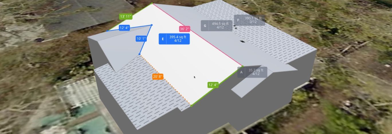
Introducing the New Property Viewer
The spotlight of Episode #1 was the new Eagleview One Property Viewer — an intuitive, graphical, and interactive way to explore property imagery and measurement data.
Our live demo walked attendees through the full experience — from logging in and placing an order to opening the new 3D viewer. We showcased how users can rotate, inspect, and interact with detailed roof models; toggle imagery and structure layers; view facets and measurements in real time; and instantly export partial or full PDF reports.
In Action: Real-World Use Cases from Jeremy at Professional Roofers
To bring the capabilities to life, our customer Jeremy, owner of Professional Roofers, joined to demonstrate how his team is already putting the Property Viewer to work across three real-world use cases:
Complex Multifamily Insurance Claims: Jeremy used the 3D models to isolate and measure standing seam areas across large apartment complexes, ensuring accurate scoping for claims and demonstrating value to adjusters.

Partial Roof Replacement Calculations: By selecting only specific roof sections, he quickly generated precise measurements to support partial repairs — transforming what used to be a manual calculation process into a few clicks.

Residential Quoting Efficiency: For a historic plantation home, he excluded metal roof sections from his quote with ease, using the viewer to generate an accurate report tailored to the homeowner’s request.

Each example underscored how the Property Viewer simplifies workflows, saves hours of manual effort, and enhances professionalism when sharing data with insurers, partners, or clients.
Exclusive preview: The “Live” Property Data App
Before wrapping up, we previewed Eagleview’s upcoming Property Data app, currently in private beta. This new capability delivers near-instant access — often in under a minute — to key roof attributes like age, condition, pitch, material, and more.
Designed for quick assessments and prospecting, it gives users the ability to pull actionable insights on demand without placing an order. It’s the next step in making Eagleview data even more accessible, interactive, and integrated into customer workflows.
Watch the Replay and Join the Journey
If you missed the live session, don’t worry — you can watch the full replay on our YouTube channel.
This first meetup sets the stage for what’s ahead: a growing community of Eagleview users exploring new features, sharing real-world experiences, and shaping the future of property intelligence together.
The next episodes of the Eagleview One Flight Meetup Series are already scheduled! We’ll continue to highlight new tools, showcase customer innovation, and bring you closer to the data that powers smarter decisions — one feature drop at a time.
Mark your calendars and register now!
Episode #2 – “The Developer Episode”
November 20th 10am PT / 1pm ET
See how developers and geospatial professionals can easily integrate high-resolution imagery and spatial data into their applications, explore new API capabilities, and get an exclusive first look at the latest Property Viewer features.
Register Now
Episode #3 – “The Property Data Episode”
December 16th 10am PT / 1pm ET
Save the date, registration is coming soon.
We look forward to seeing you soon in our next episodes!