The Regional Municipality of Wood Buffalo in Alberta, Canada, is going through a growth spurt that any city, county, state, or province would envy.
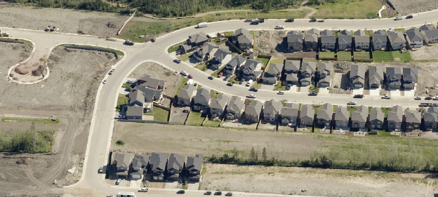
With a population over 65,000 people, Wood Buffalo has experienced rapid growth over the past few years to the tune of 1,000 building permits per month. The region, located in northeast Alberta, is home to the city of Fort McMurray and the Athabasca Oil Sands, the latter of which are arguably as large as the oil reserves found in Saudi Arabia.

Justin Ngan, Manager, Geographic Information Systems for the Regional Municipality of Wood Buffalo
“The pace of growth is a double-edged sword,” Justin Ngan, Manager of Geographic Information Systems for Wood Buffalo, told us last year. “Most cities would beg for this kind of economic development and investment. But there is a flip side to it all. That is you have to manage it —all 68,000-plus square kilometers [26,255 square miles] of it.”
Making Safety a Priority
At the top of Ngan’s list of concerns for the region was safety, and
imagery from EagleView®—formerly known as Pictometry
®— has helped him to address it.
“Our geography and other factors make us vulnerable to wildfires,” Ngan explained. “We have acres of boreal forests, long winters and a dry climate. EagleView provides us with the images and information we need to make better and more informed decisions when dealing with emergency events.”
He continued, “The imagery gives us a clear understanding of the activity that is occurring in our region so that during a wildfire, we can use that information to understand risks to people and property and respond appropriately.”
Handling the Aftermath of Disaster
Places like Wood Buffalo often develop emergency plans hoping they never need to use them.
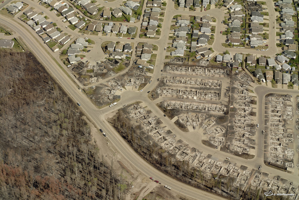
Fort McMurray after the May 2016 fire.
On May 3, 2016, a wildfire tore through Fort McMurray and forced more than 100,000 people to evacuate the region. The fire resulted from high temperatures and dry weather in the surrounding wilderness and represented the third-largest evacuation ever from an environmental disaster. Two indirect fatalities occurred during the event, but no injuries or fatalities were reported as a direct result of the fire.
The wildfire destroyed around 2,400 buildings in the region. Fort McMurray lost approximately 20% of its homes, though some communities faced even more property damage.
Central to helping Ngan and his team stay on top of the continual change are EagleView’s imagery and analytical tools.
“EagleView allows us to see every square mile of the region so that we can effectively address concerns and manage needs,” Ngan said. “Ultimately we’re accountable to every resident of the region regardless if they live in Fort McMurray, one of the hamlets, or out in the rural hinterland.”
In the event of a natural disaster like the one in Wood Buffalo, EagleView can deploy fixed-wing aircraft to provide updated, post-event EagleView imagery. Counties and municipalities can access this imagery within just days of an event, so they can begin assessing the damage as soon as possible.
Performing Equitable Assessments, Planning Thoughtfully
Wood Buffalo’s assessment team utilizes EagleView imagery to ensure that property and equipment assessments are current and equitable across the region.
“EagleView is a very important tool for our department for a number of reasons,” M. Brian Moore, Director of Assessments and Taxation, said. “Wood Buffalo is truly unique in terms of its dependence upon property taxes. In fact, 84% of our regional revenue comes from property tax. That’s more than double most municipalities. And it’s particularly important given the rapid rate of growth and development we’re currently undergoing.”
This increased demand on the property tax base requires the department to have the most robust
property assessment and taxation system. For many of Wood Buffalo’s needs, EagleView is that tool.
Richard Baron, Manager of the Assessment Branch for Wood Buffalo, added, “The area we’re responsible for is so vast and some parts so remote that you can only reach them by plane. Much of the activity involving surface disruptions are to be self-reported by the responsible parties but it’s not uncommon for reports to be filed late or simply missed. EagleView allows us to see any changes that have taken place and ensures our assessments are current, accurate, and truly reflective of what exists on a given parcel.”

An example of what ChangeFinder can show Assessors.
Baron also noted that while the imagery is helpful in adjusting evaluations up, it’s also helpful in determining when they should go down.
“Often private property values are negatively impacted by development,” Baron stated. “EagleView imagery allows us to fully appreciate those changes and make any necessary adjustments on behalf of the property owner.”
While many assessment departments would be overwhelmed by the increased workload brought on by the growth in Wood Buffalo, Moore said it’s just the opposite for his department.
“EagleView basically allows us to use our trained assessors more effectively,” Moore said. “Where they used to go out and essentially hunt for changes, thanks to EagleView they now go out knowing precisely what they’re looking for. That saves us significant time and money. Add that to the additional monies we’re picking up in assessments and EagleView basically pays for itself and then some.”
Wood Buffalo’s Public Operations Group also uses the images to make sure public resources, such as community parks and greenways, are properly maintained.
“With all the development that’s taken place, it’s important for us see the year-to-year changes, such as the amount of turf coverage,” Ngan said. “There’s a lot of work and building being done in the region, and we need to understand the landscaping needs so that we can secure the appropriate contracts for mowing and maintenance.”
Promoting Economic Tourism and Growth
Ngan and his team are planning to make their EagleView images available via a public web viewer. EagleView imagery could prove very useful in promoting investment opportunities to parties outside the region. “With the level of detail and currency of the images, it’s very easy for investors to assess opportunities and gain a better understanding of the region,” Ngan told us. “The hope is that by making the region visually accessible, we can draw more interest and activity.”
Making images publicly available improves access to the vast array of natural hiking trails, camping spots, fishing locations and winter off-road vehicle playgrounds.
“The region has so much more to offer than what you see and hear in the news,” Ngan said. “We hope that EagleView helps us to showcase Fort McMurray as a great place to live, work, and play.”