Vegetation managers are all too familiar with the challenges that overgrown trees can present around
electrical transmission lines. A tree that is too close to transmission lines or tall enough to fall onto them can cause an outage and even spark a fire. Monitoring these hazards is especially difficult when field crews are responsible for managing large work areas.
Transmission Line Hazards
Ryan Blothenburg, Western Division Transmission Line Forester for National Grid, encountered these challenges in his work. Blothenburg manages the western third of New York state, which includes roughly 2,800 circuit miles of transmission line over an 8,400-square-mile area.
Any time a problem occurred for National Grid in western New York, such a momentary outage, a field crew would have to patrol hundreds of miles of transmission lines, potentially delaying mitigation. Ground patrols included personnel on foot and riding ATVs as well as helicopters used to survey the corridor. In some cases, Blothenburg said, field crews would wind up in wetlands or other difficult-to-navigate terrain.
National Grid needed a way to view corridors and pinpoint the location of a possible outage before one might occur. Furthermore, they needed a more efficient way to send crews out into the field when mitigation is required. The faster that crews can reach the origin of an outage and determine the cause, the faster they can restore power for customers.
A Clear View of the Corridor

See your corridor more clearly with TreeRisk
In 2017, Blothenburg and his team began using
TreeRisk™ from EagleView on 350 miles of corridor to find problem areas remotely. TreeRisk helps vegetation managers pinpoint encroachment risks and confidently take action to mitigate them. With a web-based platform, up-to-date orthogonal and oblique aerial imagery, and complete datasets, TreeRisk enables users to share highly accurate maps to reduce field time and decrease mitigation expenses.
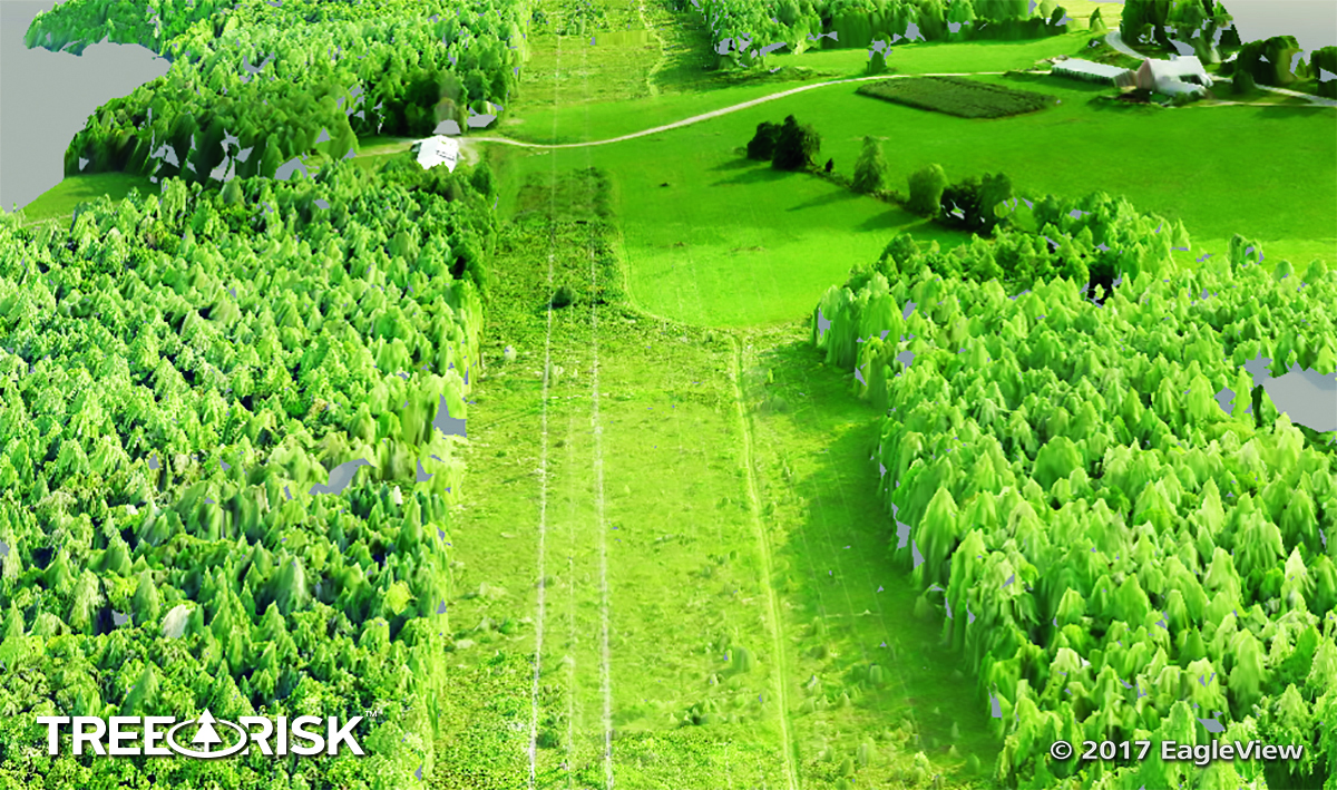
Using TreeRisk’s datasets and three-dimensional point cloud of the corridor, Blothenburg and his team were able to identify potentially hazardous areas and send field crews out systematically to review those locations. TreeRisk highlighted where vegetation was growing next to transmission lines as well as where vegetation was too tall beneath the lines.
“The biggest challenge in vegetation management is that… trees are always growing,” Blothenburg said. “It’s not a static environment that we work in, so it’s very important to establish lead times on potential problem areas. That’s where TreeRisk really shines.”
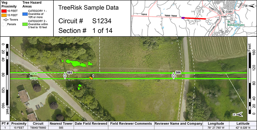
One key feature of TreeRisk is a detailed mapbook that shows proximity clearance for vegetation. This PDF file can be printed or viewed on a mobile device for use in the field.
Vegetation managers like Blothenburg can view the data in the mapbook, see where problems occur, and send field crews right to those locations. Field crews can then take the mapbook with them to refer to on location. It summarizes everything they need to know, such as latitude and longitude coordinates, pole numbers, and street names, and it includes
high-resolution aerial imagery of each segment of the corridor.
Answers to Build Confidence
Over the summer, a transmission line had “tripped” a couple of times, meaning there was a momentary outage. Blothenburg asked the transmission line department if the location had been similar both times. They confirmed that both outages had occurred within the same 20-span section.
Before using TreeRisk, Blothenburg would have had to send crews out to patrol the entire 20 spans, which could be time-consuming and difficult depending upon terrain. Yet with access to TreeRisk data, Blothenburg was able to make the process quicker and more efficient.
“What I simply did was page through my TreeRisk mapbook,” Blothenburg said. “I saw that there was only one potential location where there could be an issue from vegetation and sent a crew right there. They were there in 20 minutes and determined that [the vegetation] couldn’t have been the cause of the momentary outages. And from there our work was done, so you’re talking a huge cost savings there.”
Because he can’t see his entire region all the time, Blothenburg called this increased efficiency a big confidence builder. “You’re not sitting there the entire day to find out if [vegetation] may be the cause of the problem,” he said. “It allows you to answer the question and move on to the next task.”
Greater Accuracy
When Blothenburg began using TreeRisk, he told himself he would be happy if the solution provided even 90% accuracy. To test the accuracy of the data, he sent multiple field crews to survey the 350-mile section of corridor that TreeRisk captured.
The results greatly exceeded his expectations.
“We systematically went out and looked at the locations that TreeRisk identified as being potentially hazardous, whether it be vegetation in close proximity to the lines or trees in general that were tall enough to hit the lines,” Blothenburg explained. “We were really, really happy with the product that we got. It was just spot-on. In the vast majority of cases, we found very little false-positive data—less than 1% over that entire area.”
During the busy summer season, field crews often resort to using the “eyeball” method; they also use a variety of instruments to measure vegetation out in the field. With TreeRisk, however, crews can crosscheck their field measurements and perception with the highly accurate data found in EagleView’s solution.
Increased Efficiency and Prioritization

A sample of the TreeRisk MapBook
Prior to using TreeRisk, Blothenburg’s team would fly the entire line with a helicopter each year—a costly expenditure. Now they only need to fly where there are problem areas, as shown in TreeRisk.
TreeRisk also enables them to be more efficient about when and where they dispatch workers. This process promotes better use of employee time and productivity, and it also prevents problems with transmission lines and the costs associated with them.
By preventing outages, National Grid can avoid losing revenue, performing expensive restorations and unnecessary patrols, and paying regulatory fines for improper vegetation management.
To achieve these goals, vegetation managers need to categorize hazards correctly and prioritize mitigation in an effective manner.
“If a tree falls and it does hit [a transmission line], you’ve got technology to back you up that you did your work in the proper areas and prioritized correctly,” Blothenburg said.
“We constantly evaluate the importance of lines based on what cities they supply power to,” he continued. This includes any sensitive customers within those cities, like hospitals. “We try to prioritize our work based on that, and TreeRisk really helps with that as well.”
Proactive Vegetation Management
Vegetation management professionals need as much data as possible to understand potential problems and remain proactive.
“With the timing of when we get that data, it gives us a great advantage to be able to go out there in the wintertime prior to the trees growing and take care of those issues,” Blothenburg said of TreeRisk.
In the future, Blothenburg said, he can see using this data to spread efficiency to other functions, such as bidding work, assigning crews by geographic area, and knowing the type of equipment needed in certain areas.
While other solutions fell short for National Grid in terms of precision and efficiency, TreeRisk has restored Blothenburg’s confidence in technology for vegetation management.
“The data was superb—far better than I expected,” he said. “It allowed for a tremendous increase in efficiency…. What TreeRisk does is that it allows you to identify those areas through technology without having seen them personally. It was a wonderful tool for identifying hotspots before we actually knew by seeing with our own eyes where they were.”
Learn More about TreeRisk
Visit www.eagleview.com/treerisk or email treerisk@eagleview.com to schedule a demo.
 Vegetation managers are all too familiar with the challenges that overgrown trees can present around electrical transmission lines. A tree that is too close to transmission lines or tall enough to fall onto them can cause an outage and even spark a fire. Monitoring these hazards is especially difficult when field crews are responsible for managing large work areas.


