In May 2007 the Boulder County Assessor’s office had the opportunity to participate in a group purchase of EagleView imagery (formerly Pictometry).
“We jumped at the chance,” says Cindy Braddock, Chief Deputy Assessor in the Assessor’s Office. “At that point in time our dollars were very tight and we couldn’t afford to put cars out in the field at the rate and where we needed to,” she explains. “About half of Boulder County is in the Rockies. A good portion of our properties are way up in the hills. They often have long, steep drives and, in general, are very difficult to get to.”
Using EagleView's aerial imagery and online analytical tools, the County was able to identify previously unaccounted for structures ranging from barns and garages to cabins and pool houses.
Braddock notes, “EagleView imagery enabled us to get our tax rolls completely up-to-date in a remarkably short period of time. In 2011 we conducted a second flyover, giving us the most comprehensive and current data set in County history.”
Little did Braddock and her colleagues realize how invaluable that data set would become.
Fast forward to September 9, 2013, when the first drops of what would ultimately be labeled “a 1,000-year rain and a 100-year flood” began. Over the next eight days the rain fell non-stop, topping out at 20 inches in some areas.
In the end, the relentless rain and associated flooding and mudslides destroyed 1,502 homes and damaged another 17,494. With hundreds of miles of roads and infrastructure literally washed away, the County was faced with the seemingly impossible task of assessing the damage.
“Almost immediately our County Assessor Jerry Roberts put the wheels in motion to conduct another flyover,” says Braddock. “The folks at EagleView responded as soon as they had approval — actually before they even had a contract. The new imagery they gathered has been absolutely vital to our ability to assist residents.”
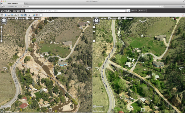
By comparing the images from 2011 against the new images gathered even while flood waters were still receding, the County was able to do a complete and accurate post-flood analysis.
“The split-screen imagery gives us a clear view of the true damage,” says Braddock. “Many of the homes we’re evaluating on our desktops are in areas that, still today, are not accessible by vehicle. We can call up a set of images and immediately determine the extent of damage, or in some cases complete destruction, and adjust the taxable value of the property. Sadly, in some instances that includes removing some homes from the property roll altogether. In the past, those kinds of adjustments might have taken weeks or months to do but EagleView imagery allows us to do an evaluation and make a pro-rated adjustment in a matter of minutes.”
Beyond the Assessor’s Office, other County agencies are using EagleView imagery to assist with recovery and avoid future disasters.
“The detail of the EagleView images allows us to see where walls were breached in retention ponds and identify different types of debris including trees, rocks and gravel,” says Braddock. “All that’s incredibly helpful to the various departments — Land Use & Permitting, Transportation Road Maintenance, Parks & Open Spaces — as they take steps to rebuild. I can’t say enough about the positive impact EagleView imagery has had on our County’s effort to recover from the flooding. It’s an incredibly powerful tool and my appreciation to my rep and the entire EagleView team for their ability to get the flights done so quickly and get the data to us, well, it knows no bounds.”