Roofing contractors require accuracy when using aerial measurements for bidding, estimating and planning production. Incorrect measurements can translate into hundreds or thousands of dollars lost on a job.
The resolution and timeliness of the aerial imagery that is used to derive the measurements is a key factor in the accuracy. Buildings undergo constant change and when an aerial image is not current, the possibility that a piece of the structure has been added or removed is unforeseeable, leaving the contractor’s measurements useless.
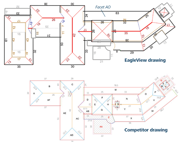
Short by 34 Squares
Recently, an EagleView competitor delivered a measurement report to a contractor that was derived using satellite imagery freely available on the internet that was captured in 2014. EagleView measured that same property using 2015
Pictometry® Intelligent Imagery® along with its patented 3D technologies and found that the competitor’s report was short by 34 squares. How is it possible to be so far off?
The competitor used outdated consumer-grade imagery that failed to capture a large addition that had been added to the north side of the structure. Beyond that obvious error, EagleView’s quality assurance technician took a closer look.
“Approximately 323 square feet of the remaining variance can be attributed to the competitor under measuring facet M on their report (or AO on the EagleView report). Adjusting for this error would drop the total area variance to 3.5 percent,” Zac Long, QA/QV Technician, EagleView Technologies explained. “Any remaining discrepancies appear to be from slight differences in measurements between the two reports and some smaller instances of under measurement on the competitor’s report.”
Why Professional-Grade Imagery Matters
Up-to-date and accurate imagery is especially important for presenting measurement reports or proposals to prospective customers in the roofing industry. EagleView uses current, high-resolution Pictometry images from the top-down and north, south, east and west directions along with the creation of a 3D model to be sure that the measurements are correct and each part of the structure is accounted for. With a fleet of more than 100 aircraft flying the U.S. and Canada year-round, contractors can be assured they have the most recent images for their reports.
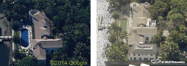
The comparison of the reports and discovering the differences in measurements proves how crucial using up-to-date, high-resolution imagery and 3D modeling technologies is while measuring. The competitor’s measurements based on satellite imagery did not account for any changes the structure had undergone within the past year, rendering their measurements and official report useless for that contractor in the end.
Appearing professional to prospective customers is essential when asking for the project, being confident in the accuracy of your measurement tools is a sure way to do so. Satellite imagery can range from one-to-three years old, which is a large window of time when several changes can occur to a structure. Satellite imagery offers 45-degree views that appear similar to Pictometry oblique imagery but features cannot be measured using these views. The imagery is augmented by parallel projection which distorts features in the distance, compromising the ability to measure. Relying on this type of imagery for accurate measurements of a structure is a risk.
“Overall the EagleView report is considerably more accurate due to more updated imagery and a better rendering of the actual roof surface,” concluded Long.
Order and view detailed measurements on the go