AI for Accuracy: How Sketch Verification Is Helping Counties Recover Lost Tax Revenue

AI for Accuracy: How Sketch Verification Is Helping Counties Recover Lost Tax Revenue
Artificial Intelligence is often associated with complex algorithms and futuristic tools—but its most powerful applications may be solving some of the most persistent, grounded challenges in local government. Take property data, for example. For many counties, inaccurate building sketches stored in CAMA systems quietly drain potential revenue, undermine fair assessments, and slow down field operations.
That’s where EagleView’s Sketch Inspect comes in. Powered by high-resolution aerial imagery and intelligent automation, this sketch verification tool uses AI-driven insights to help local governments bring their records up to date—recovering value that might otherwise go unnoticed.
The Challenge: Incomplete Data, Hidden Value
Local governments rely on accurate sketch data to determine property values, calculate assessments, and fund essential services. But over time, discrepancies accumulate. Buildings are added or modified without permits. Sketches fail to reflect reality. Staffing shortages make it difficult to keep pace.
Traditional methods—like manual field inspections or change detection based on year-over-year imagery—help, but they have limitations. Change detection reveals what’s new. Sketch Inspect reveals what’s always been wrong.
AI in Action: How Sketch Inspect Works
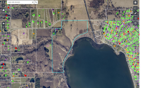
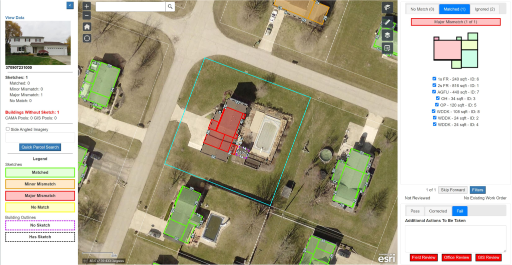
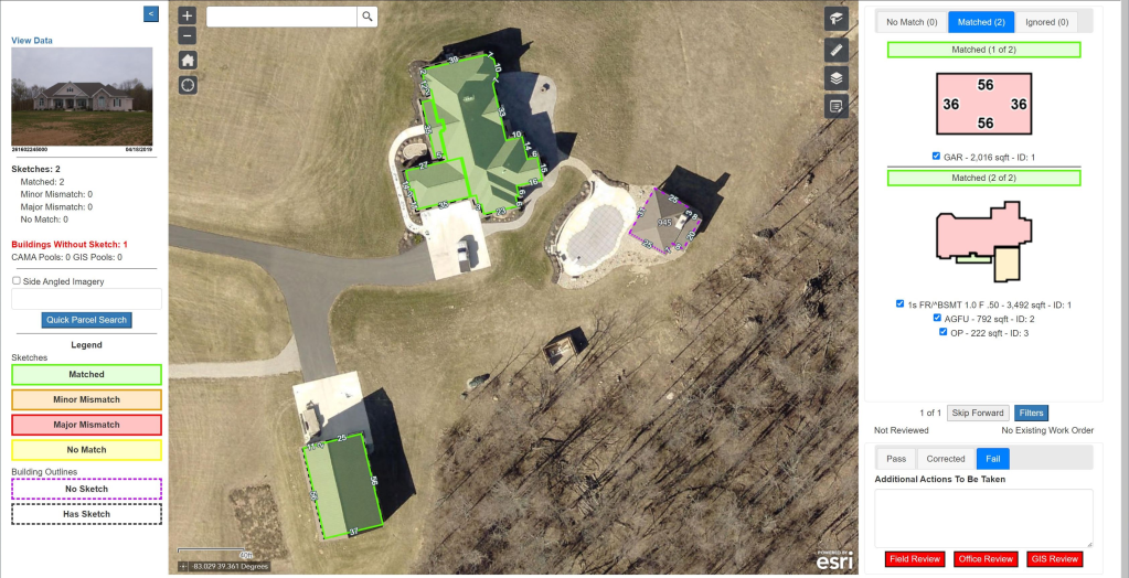
Sketch Inspect compares parcel sketches from CAMA systems to building footprints derived from recent aerial imagery. The solution uses machine learning and geospatial analytics to automatically identify and classify discrepancies—flagging parcels with mismatches and highlighting those with missing structures entirely.
Key capabilities include:
- Automated Comparison: Proprietary algorithms overlay sketches with imagery to identify discrepancies in size, shape, or location.
- Discrepancy Classification: Each property is labeled with a match status—green for alignment, orange for minor differences, red for major mismatches, and purple for missing sketches.
- Prioritized Review: A visual dashboard allows users to filter and sort by severity, location, or structure type—making it easy to focus on what matters most.
- Fast Turnaround: Most customers receive results within 30 days of submitting data—accelerating reappraisals and data clean-up efforts.
As EagleView Senior Product Manager Elliott Cox noted during a recent webinar, “It’s all about giving assessors a new, accurate baseline for their sketch data.”
Real Results: Medina County, OH
Medina County’s experience with Sketch Inspect highlights what’s possible when governments pair AI with aerial intelligence.
Facing a countywide reappraisal, a new leadership team inherited a CAMA system plagued by inconsistencies and outdated processes. Within weeks of implementing Sketch Inspect, they discovered:
- More than 9,000 major mismatches or missing sketches
- $40 million in newly identified taxable value
- $14 million in recovered property tax revenue
- Up to 2 months of fieldwork saved by prioritizing high-impact parcels
“Sketch Inspect gave us a reset button,” said John Hunter, Director of IT and Strategy for Medina County. “We didn’t trust the integrity of our data—and this helped us regain control.”

The impact extended beyond the tax office. Improved property records supported economic development, emergency response, and cross-agency planning—maximizing the return on a single imagery investment.
Building a Smarter, Fairer Future
Sketch Inspect isn’t just about AI—it’s about accuracy. When governments have the tools to identify what’s missing and where, they can correct long-standing gaps, recover lost revenue, and deliver services more equitably.
And because the technology is scalable, counties of any size can benefit. Whether you're preparing for a reappraisal, modernizing your systems, or simply trying to ensure fairness across the tax roll, AI-powered sketch verification offers a high-impact, low-friction starting point.
As Hunter observed, “You pay for the flight once, and it becomes a multiplier—delivering benefits to every department that touches spatial data.”
Ready to Reset?
With growing expectations for transparency and efficiency, the time to modernize property data is now. EagleView’s Sketch Inspect is helping counties take the guesswork out of valuation—and turn imagery into actionable intelligence.
Learn more about how AI-powered sketch verification can help your jurisdiction.