A property data application programming interface (API) gives you instant access to verified property measurements, imagery, and attributes, without manual site visits or data entry. For industries like construction, insurance, government, and solar, that means faster estimates and smarter decisions driven by real data instead of guesswork.
In this post, we’ll explain how property data APIs work, what kind of property insights they provide, and how teams use them to automate everything from takeoffs to claims documentation. You’ll learn which workflows benefit most and how API integration can scale your operations with minimal setup.
How a Property Data API Works and Why It’s Essential for Modern Workflows
A property data API is a digital bridge between your internal systems and external sources of verified property information. It lets software applications communicate directly with property databases to request specific data (such as roof dimensions, building outlines, or aerial imagery) and receive structured, ready-to-use results in real time.
Instead of manually collecting photos or taking measurements on-site, teams can send an API request and instantly receive consistent data that feeds into their existing workflows.
The API acts as a translator: your system asks for the data it needs, and the provider’s servers respond with precise property measurements, attributes, and imagery in a standardized format like JavaScript object notation (JSON) or extensible markup language (XML).
This makes property data APIs an essential tool for organizations managing large volumes of projects. Property data APIs eliminate repetitive tasks and ensure every stakeholder works from the same accurate dataset.
Who Benefits from Using a Property Data API?
- Roofing contractors and construction teams streamline takeoffs, build competitive estimates, and order materials with confidence.
- Insurance carriers and adjusters verify damage, document claims, and accelerate settlement decisions.
- Solar designers and installers size PV systems, model shade, and finalize plan sets without repeat site visits.
- Facility managers and real estate teams assess portfolios at scale, monitor assets, and prepare capital plans.
How Property Data APIs are Enhancing Manual Workflows
Speed and consistency
Property data APIs eliminate the stop-and-start rhythm of manual work. Your systems automatically request the same verified outputs every time in a uniform format. That consistency means every estimate or claim uses identical baselines, no matter who pulls the data. Teams can move from property address to preliminary takeoff in minutes with zero rework between departments.
Accuracy that drives profitability
Manual measurements and drone flyovers introduce variation that compounds across projects. A few inches off per slope can translate into thousands of dollars in over- or under-ordering materials. Property data APIs deliver centimeter-level accuracy using high-resolution aerial imagery and 3D modeling validated against real-world field checks.
Lower risk and safer operations
Every unnecessary site visit carries cost and exposure: ladder climbs, travel time, and liability. With a property data API, your team can collect measurement-grade data remotely, reducing on-site work. After a storm, you can triage hundreds of properties from the office, identify the ones that truly need inspection, and deploy crews only where hands-on work is required.
Built for peak demand
When hail season hits or a new solar market opens, capacity becomes the bottleneck. Property data APIs let your team process thousands of addresses in parallel, automatically queuing requests as jobs are created in your customer relationship management system (CRM) or estimating system.
What Data Can Property Data APIs Deliver?
Specific fields vary by product and use case, but you can expect access to:
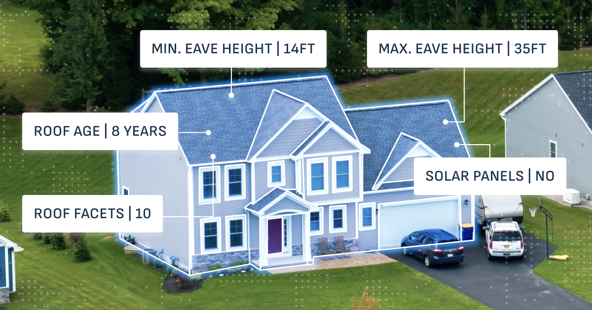
- Measurement data: Total roof area, slope, ridge and valley lengths, facet count, wall dimensions, and openings. All of these data points are delivered in a structured, machine-readable format for continued estimating and design.
- High-resolution imagery: Orthogonal (top-down) and oblique (angled) aerial photos provide a level of clarity and spatial context that standard satellite imagery can’t match, supporting precise measurement and visual verification.
- Property attributes and condition insights: Surface materials, obstruction mapping, solar shade metrics, and condition indicators (when paired with AI analysis) help teams evaluate properties before anyone steps on site.
- Deliverables and file outputs: Detailed diagrams, CAD files for solar design, and formatted PDF reports integrate directly into your quoting, design, or claims systems. This means less or the complete removal of manual conversion and data re-entry.
The chart below shows how a property data API moves information from request to action by turning raw property data into automated outputs your systems can use immediately.
| Stage | What Happens | Example Output | Business Impact |
| 1. Request | Your system sends an API call with a property address, parcel ID, or coordinates. | POST
/v1/property-data/requests | Eliminates manual data entry and file uploads. |
| 2. Processing | The API retrieves aerial imagery and runs measurement models in the background. | Roof geometry, wall outlines, and surface attributes are calculated automatically. | Reduces human error and speeds up estimation. |
| 3. Delivery | The API returns structured data (JSON/XML), imagery links, and downloadable files (PDF, CAD). | JSON with measurements, CAD for design, and PDF for documentation. | Provides standardized, ready-to-use results for all teams. |
| 4. Automation | Your system triggers next steps—quote creation, claim updates, or material orders—based on API outputs. | Automated job creation or purchase order draft. | Converts data into immediate operational action. |
| 5. Storage & Sync | Files and data sync across your CRM, project management, and inventory tools. | Linked diagrams and measurement data are stored in one record. | Creates a single source of truth across departments. |
Integrating Property Data APIs: Key Workflows and Applications
A property data API is a way to give your property intelligence a unified system across your entire tech stack. Once integrated, it can automate key steps in estimation, design, inspection, and portfolio management. Doing this eliminates the friction between your CRM, quoting tools, and production systems.
Here are a few workflows and applications a property data API can improve:
Roofing and exterior construction
- Instant pre-bid takeoffs: Instead of sending crews to every address, estimators can submit a property request and receive verified roof geometry, slope, and pitch in minutes. This enables same-day quoting for storm response or retail bids, helping contractors reach homeowners first with defensible numbers.
- Material planning: Property data APIs convert measurements directly into SKUs and quantities within your estimating or ordering platform. Once a proposal is approved, a purchase order can be auto-generated for suppliers.
- Change-order control: When a homeowner alters the design or a remodel shifts scope, you can re-request updated measurements from the API. This ensures every revision aligns with real property data, preventing miscuts, material waste, and costly return trips.
Insurance claims and catastrophe response
- Triage at scale: After a storm, push thousands of addresses through the API to prioritize inspections by severity and accessibility.
- Defensible documentation: APIs automatically pull verified measurements, diagrams, and imagery into each claim file.
- Drone assist: When additional evidence is required, a potential solution might be a solution like Eagleview Assess™.
Solar design and operations
- Rapid site design: API integration lets solar teams fetch roof geometry, obstructions, and shading data instantly. Designers can generate panel layouts and energy production models automatically, cutting design time from days to hours.
- CAD handoff: Fetch CAD files to feed your design automation and submission pipeline.
- Portfolio pricing: Developers and sales teams can standardize pre-sales assumptions across regions using the same property data for every proposal.
Facilities and real estate
- Portfolio assessments: Roll up roof and envelope metrics for multi-site maintenance planning.
- Vendor alignment: Share the same property diagrams with suppliers and contractors to reduce quoting variance.
- Capital planning: Track lifecycle events using consistent, API-fetched attributes.
Elevate Your Property Data API Program With Eagleview’s High-Resolution Intelligence
When you integrate with Eagleview, your systems gain access to high-resolution images, advanced 3D modeling, and continuous nationwide coverage.
Why Eagleview data sets the standard:
- Scale and coverage: Over 3.5 billion high-resolution aerial images fuel robust, repeatable measurements across the U.S. and Canada, so your integration scales wherever you operate.
- Unmatched clarity: Imagery up to 70× the resolution of typical satellite sources improves visual detection, measurement accuracy, and plan quality.
- Proven precision: Measurements consistently achieve 98%+ accuracy, giving contractors, insurers, and solar providers confidence in every decision.
These capabilities form the foundation of accurate, defensible property data. It’s why 24 of the top 25 insurers and leading construction, solar, and facility management organizations standardize their workflows on Eagleview.
Where Eagleview fits in your stack:
A property data API becomes even more powerful when it’s embedded directly into the tools your teams already use:
- CRM and quoting systems: Automatically push new opportunities to the API and pull back verified measurements for faster, more accurate pricing.
- Project management and PSA tools: Trigger new tasks as soon as reports are ready and attach PDFs or imagery directly to each job record.
- Procurement and inventory platforms: Convert API-delivered takeoffs into purchase orders, track material usage, and reconcile actuals against estimates.
- Design and engineering software: Import JSON, computer-aided design (CAD), and PDF outputs directly into modeling tools for solar layouts or as-built documentation.
See How Eagleview’s Property Data API Can Streamline and Scale Your Workflow
To streamline your systems, your main goals are to eliminate site visits and manual data entry. With Eagleview’s Property Data API, you can pull verified measurements and imagery straight into your workflow for faster, smarter decisions.
Book a free demo to bring precision and performance to your team’s workflows.
FAQ
What makes a property data API different from map tiles or generic GIS layers?
A property data API returns measurement-grade outputs (roof area, pitch, wall dimensions) and high-resolution imagery, not just basemaps. That precision lets you make pricing and claims decisions with confidence. It includes insights such as the presence of structures, shading for solar, etc.
How accurate are the measurements?
Eagleview data is built for precision, with ≥98%+ measurement accuracy and imagery clarity that outperforms typical satellite sources. Accuracy varies by product; your rep can advise which outputs match your workflow.
Can we combine API data with drone inspections?
Yes. Use Eagleview Assess™ to capture on-demand imagery and AI damage detection when conditions change, then keep your claim or job record in sync through the same system of record.
Which deliverables can Eagleview automate?
Common outputs include JSON measurements, PDFs for documentation, oblique and orthogonal imagery, and (for solar) CAD files that feed your design and permitting steps.
How do we handle high volumes during CAT events or peak season?
Build your integration with idempotent requests, webhooks, and retry logic. The API model scales horizontally, so you can submit more addresses without adding manual work.
How long does it take to integrate a property data API?
Most teams can connect their systems within a few development sprints. Once authenticated, requests and responses can be tested in a staging environment before going live in production.
Is there a limit to how many properties we can process?
Eagleview's imagery and data covers nearly all of the U.S. and much of Canada. The API allows you to get the details of any property that is part of that library.
How is data security handled?
All requests and responses are encrypted over HTTPS, and API keys or OAuth tokens ensure only authorized systems can access property data. Audit logs can also be maintained for compliance.