Providing Public Works Services is Challenging
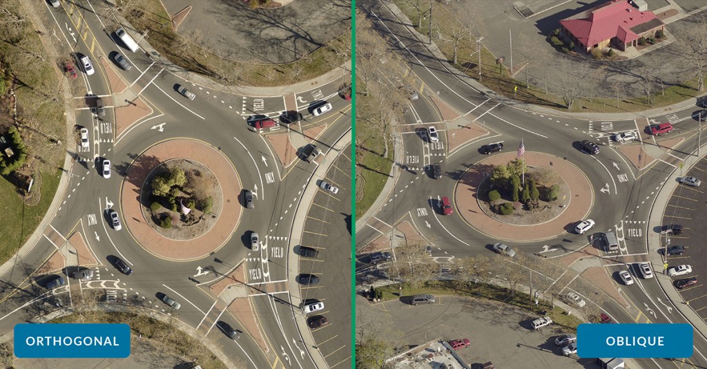 See the additional context provided by the oblique image of this roundabout, especially the ability to see what kinds of street signs surround it.
Public Works departments are responsible for ensuring the prudent use, maintenance, and upkeep of publicly-owned property, infrastructure, and assets.
Public Works is generally made up of multiple divisions, and involves the operation and maintenance of a variety of resources, including streets, storm sewers, drinking water systems, sanitation, and parks.
By efficiently managing these assets, Public Works departments are able to get the highest possible value out of public investments, act as good stewards of local resources, and help their community keep up with development and expansion.
However, with so many moving parts, efficiently planning projects, managing resources, and maintaining assets in the field can be a challenge. Many departments likely use orthogonal imagery, which provides a top-down 90-degree angle view, to help manage the work. Unfortunately, public assets and infrastructure may be difficult to identify and inspect with only an orthogonal view.
To work as efficiently and cost-effectively as possible, Public Works departments need more context and perspective to quickly locate assets, as well as coordinate a complex system of projects and teams.
EagleView's Oblique Aerial Imagery Can Help
The more information Public Works departments have about a location, the quicker they’re able to get that job done, and the more time and money they can save.
With EagleView’s high-resolution oblique aerial imagery, Public Works teams can inspect assets and infrastructure remotely, allowing them to get a more complete understanding of location and condition without the need for an on-site inspection.
Oblique imagery is taken at a 40-to-50-degree angle from low flying aircraft equipped with a camera system that rapidly captures images from all perspectives, offering a clear view from all cardinal directions. These perspectives can then be served together to create a broad-scale, holistic world view.
This enables Public Works teams to utilize ‘ground-truthing’ to remotely verify assets in the field (such as signs and traffic lights), and avoid misidentifying structural, situational, and topographical details.
This guide will explore the benefits of EagleView's oblique aerial imagery for Public Works, including the ability to:
- Remotely locate, inspect, and manage assets and infrastructure.
- Efficiently manage stormwater, drainage, and capital improvement projects.
- Integrate oblique aerial imagery with existing workflows and software platforms.
1. Remotely Locate, Inspect, and Manage Assets and Infrastructure
Locate and Inspect
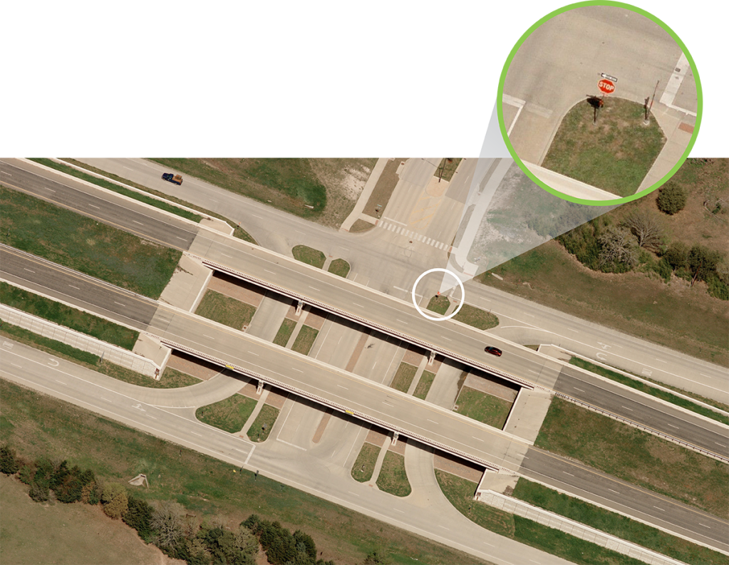
EagleView's oblique aerial imagery offers the accuracy Public Works teams need to remotely identify and inventory landmarks, lights, signs, and other assets that would be hard to clearly see from top-down ortho imagery alone.
With high-resolution oblique imagery, you’re able to:
- View assets from all cardinal directions, providing context unavailable in orthogonal imagery.
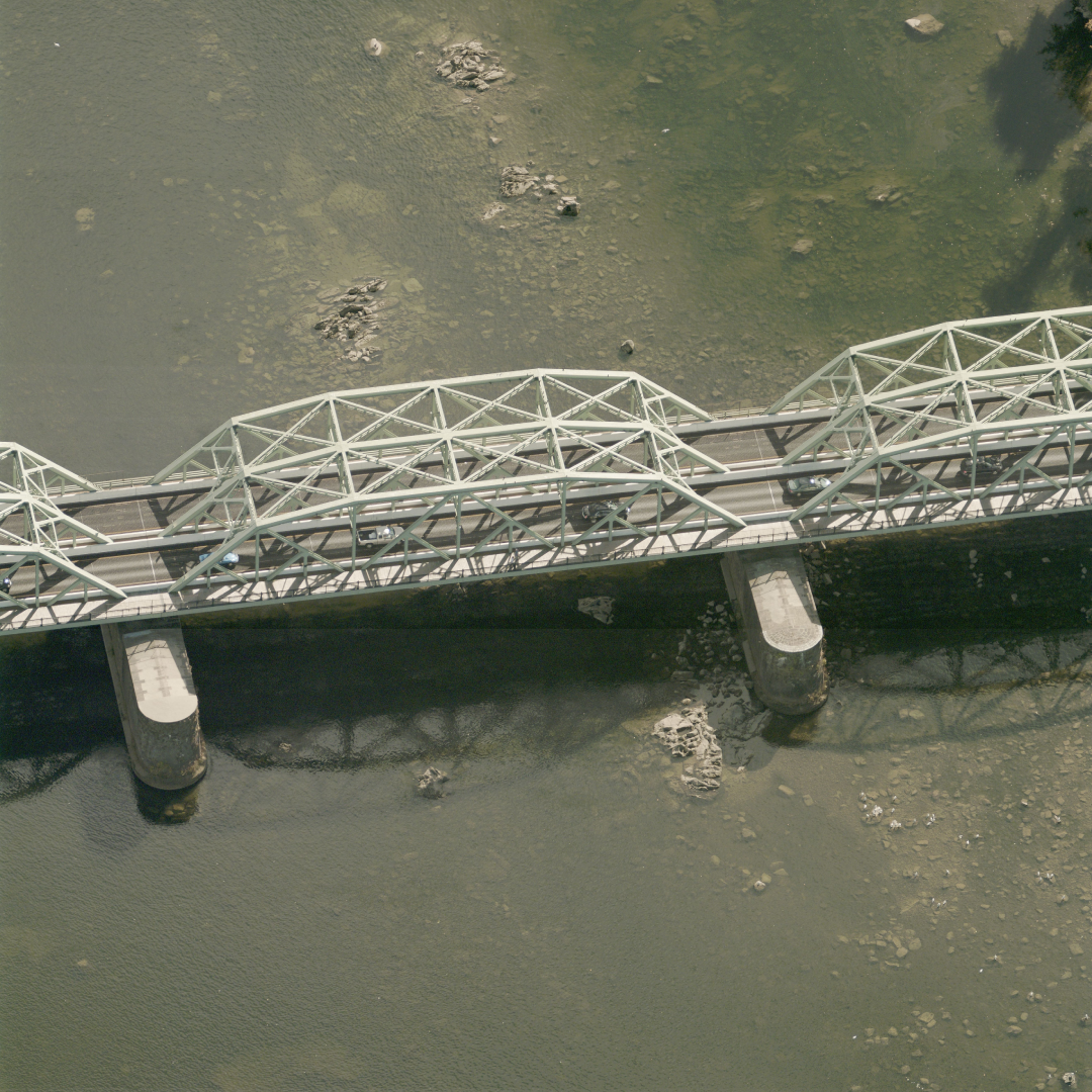
- Remotely measure, track, verify, inspect, and report on the status of roads, bridges, signage, and other infrastructure and assets.
- Mark a geo-accurate XY coordinate location for each asset.
Efficiently Manage Field Repairs
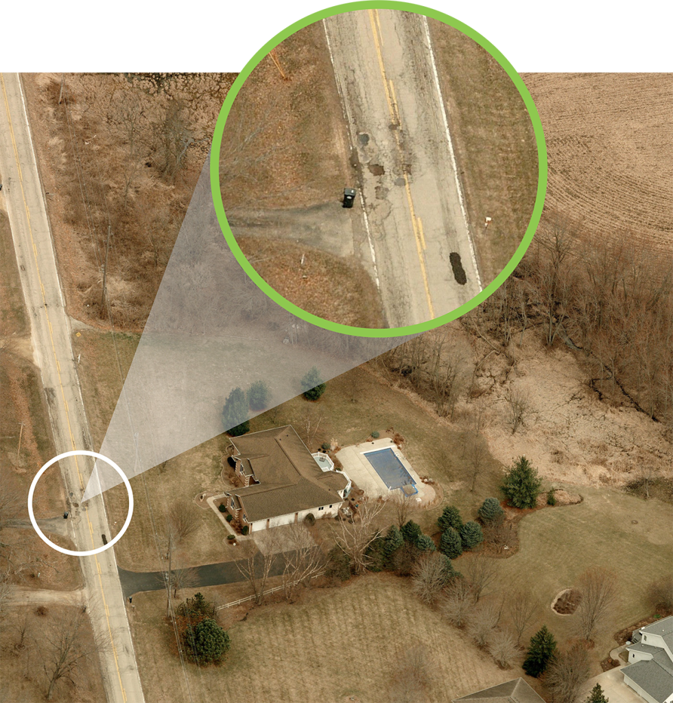
This information can be used to create maps for a variety of uses as well as initiate work orders to multiple departments at once (e.g., if damage is detected to both the street and nearby signage, work orders can be efficiently assigned to the appropriate departments based on that single remote inspection).
EagleView’s oblique aerial imagery allows Public Works departments to understand and address the condition of all key elements of community infrastructure–all without leaving the office.
Access Imagery in the Field
While aerial imagery can support a variety of remote tasks, sometimes a field visit is unavoidable. The EagleView mobile app is ideal for professionals who need information and access to imagery while out of the office.
CONNECTMobile™ lets users access EagleView imagery on an Android or iOS-powered mobile device – ideal for situations when a field visit is required.
2. Efficiently Manage Drainage, Stormwater, and Capital Improvement Projects
Drainage and Stormwater
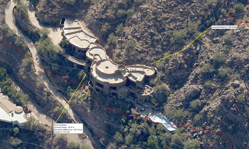
As local governments develop and execute growth plans, it’s important to understand how terrain will impact expansion and water flow.
Working with their GIS department, Public Works departments can use EagleView oblique imagery and elevation data to view contours, measure true ground distance, and manage drainage. EagleView aerial imagery can also be used to identify impervious surfaces and help calculate stormwater fees.
Capital Improvements
Oblique aerial imagery can also be used to help plan and execute capital improvement projects, including the ability to:
- Gather environmental information when determining site selection.
- Use imagery to visualize projects and gain stakeholder approval.
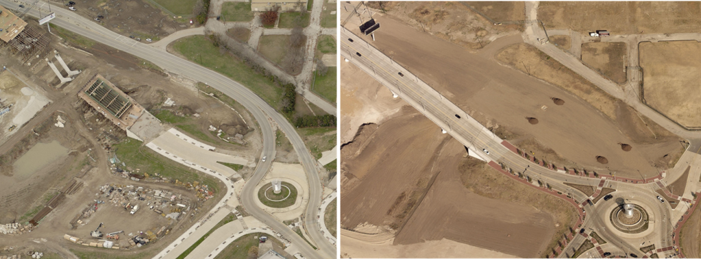
- Access historical imagery to track progress and visualize change.
3. Integrate With Your Existing Workflow
Esri Integration
Esri users can access EagleView’s oblique and orthogonal imagery directly within the Esri platform and other data visualization tools, including the ability to:
- Remove the cost and complexity of third-party imagery and datasets.
- Make it easy for other departments to leverage the imagery and data alongside what they're already creating and maintaining.
- Overlay GIS data layers on both ortho and oblique imagery to provide important context.
- Enrich existing GIS layers by adding additional attributes, such as the type of siding for buildings, or the color of fire hydrants.
- Heads-up digitize assets and features on ortho and oblique imagery, and download vector layers to Shapefile or KML to import to ArcGIS.
There are countless ways to integrate EagleView into your Esri applications and third-party Esri-based applications:
- EagleView for ArcGIS Desktop, ArcGIS Pro, and Web AppBuilder Developer Edition.
- Integrate our oblique imagery into your ArcGIS Online Web Mapping Applications using our JavaScript web-based API.
- Use the EagleView ortho as a basemap in web maps, ArcGIS Online apps, and in ArcGIS Pro or ArcMap using our REST cloud-based Image Service.
- Access orthomosaics in WMS, WMTS, and TMS format.
- Use EagleView CONNECTExplorer or a custom web-map creation to overlay published REST data for a powerful combination of imagery and local data.
Cityworks Integration
Government agencies rely on aerial imagery to verify assets and reveal details of critical structures—without the need for a field visit.
To help make this process even more efficient, Cityworks users in the U.S. and Canada can view and access their high-resolution EagleView oblique and ortho imagery from within the Cityworks Esri map viewer. This enables them to:
- Increase productivity and eliminate the need to switch between multiple applications.
- Remotely identify and measure roads, bridges, and other key infrastructure.
- Collaborate within one environment with other local government departments.
Certified Imagery With TrueTouch™
Certified Orthomosaic and TrueTouch imagery enhancements are additional tools available from EagleView to help Public Works departments locate and visualize assets in the field.
Orthomosaics are image maps that have been produced to accurately represent the geography of an area. They’re created by combining a collection of overlapping ortho images (aerial imagery that’s free of distortion and geometrically corrected to produce a uniform scale). An orthomosaic view allows users across government departments to easily scroll and pan across a unified image to get a more accurate and complete view, versus loading and inspecting separate individual images of an area.
EagleView also offers Certified Orthomosaic imagery, where an orthomosaic is validated for geospatial accuracy by our licensed engineering and surveying team, with the additional use of surveyed ground control, and produced in accordance with state and local requirements.
EagleView TrueTouch applies visual enhancements to critical features in the orthomosaic imagery by:
- Removing evidence of seams and distortions.
- Removing inconsistencies related to tall building lean, time of day, changes in imagery capture, cloud shadow, and a variety of other issues.
- Improving image quality, assuring positional accuracy, and providing accurate representation across all features (e.g., roads, bridges, large buildings, and landmarks).
Geospatial 3D Mesh Layers
EagleView’s partnership with Skyline offers additional ways to visualize your geospatial data using 3D mesh layers.
Government agencies use geo-referenced 3D mesh layers for urban planning, asset management, flood management, emergency response planning, tax assessments, and other critical functions.
EagleView’s high-resolution oblique imagery can be delivered with both 3DML files for viewing in Skyline’s TerraExplorer web-based GIS viewer and editor, along with SLPK files for viewing in Esri’s ArcGIS Online, ArcGIS Pro, and ArcGIS Urban platforms. Users can view scenes in 3D and use GIS tools such as viewshed and line-of-sight calculation.
- Highest Resolution—Reproduce the smallest details, including cars, trees, fences, and walls with advanced color balancing and high-quality texturing.
- Multiple Output Formats—Export in a variety of formats and resolutions, including 3” – 6” GSD, 3DML, and SLPK.
- Superior Precision—View accurate representations of intricate features, details, geometry, and color with high-quality texturing.
- Intuitive Interface—Access powerful visualization capabilities and tools, including photo projection on terrain and project preview to streamline evaluation and adjustments to parameters.
Get Started Today
To learn more about how EagleView solutions can help meet your Public Works department's needs or to request a demo, visit https://www.eagleview.com/industry/government/.