25 Years Later, Eagleview’s Disaster Response Program Continues To Scale to Respond to Increasing Climate Disasters
Natural disasters in America are increasing 2-3x from previous standards, but program launched in the aftermath of September 11, 2001 provides valuable aerial imagery to help governments, insurance and broader industry respond effectively.
ROCHESTER, N.Y., Oct. 19, 2026 – In the past five years, the U.S. has experienced a yearly rise in major climate disasters. 2023 had 28. 2024 was 17. 2025 was 21. That is roughly 2-3x more than the long-term average, which is approximately nine, according to NOAA. These major climate disasters cost roughly a billion dollars. Many, including forest fires, far exceed that billion-dollar price tag. Even in years with fewer predicted weather events, organizations are still at elevated risk from any single event.
Eagleview's Disaster Response Program (DRP) provides rapid post-disaster aerial imagery and property data to customers.
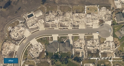
Eagleview DRP orthogonal imagery captured in March and August 2026 shows after conditions in a Spokane-area neighborhood impacted by wildfire.
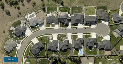
Eagleview DRP orthogonal imagery captured in March and August 2026 shows before conditions in a Spokane-area neighborhood impacted by wildfire.
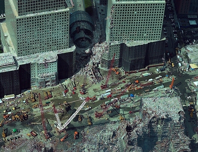
Image shows the site in NYC on 9/11 after Eagleview flew its first DRP flights to support the recovery efforts.
Often recovery is hampered by the capacity of responders, insurers, and other industry partners to understand the true severity of the damage. In those instances, aerial imagery determines the picture of risk for a professional, by showcasing how likely a roof is to fail, or how much storm damage a property has incurred, or the real condition of an asset. Without that information, wrong or unverifiable risk pictures cost insurers, contractors, government personnel and other industry leaders time and money. When the data isn't trusted enough to act on, the fallback is manual verification which eats valuable time and raises the costs of inspection.
Eagleview, one of the leading providers of aerial imagery, geospatial data, and property intelligence, provides those images in situations of crisis. And this year it's recognizing the 25th anniversary of its Disaster Response Program (DRP) which has grown from a single aerial mission flown in the aftermath of the September 11, 2001 attacks into an embedded, year-round operation supporting post-disaster recovery efforts nationwide.
"When we launched this effort 25 years ago, it was a singular response to a singular event," said Piers Dormeyer, CEO of Eagleview. "Today, we have a team behind this. Our customers don't experience disasters one at a time anymore, and neither can we. DRP exists so we can ensure people are safe, governments are supported, and the imagery that's needed to plan a recovery is there as quickly as possible."
From a Single Mission to a Standing Capability
In 2001, the company, then a small Rochester, New York-based startup, captured aerial imagery of the World Trade Center site in the weeks following the September 11 attacks and made that imagery available to responders on the ground. The mission, undertaken without a formal program in place, established the operating principle the company has built on ever since: that timely, geographically accurate imagery helps communities and institutions understand what has changed and make faster, better-informed recovery decisions.
That premise was tested at scale during Hurricane Katrina, when Eagleview's existing pre-event imagery of Orleans Parish, Louisiana enabled a direct comparison between pre- and post-storm conditions and supported the parish's recovery efforts for years afterward. It was during this period that the company further formalized the program and began offering it as a function customers could expect to rely on.
Over the past 25 years, DRP has supported government agencies, insurers, and infrastructure operators following hurricanes, wildfires, tornadoes, floods, and earthquakes across the United States, Canada, and Haiti. In the past two years alone, the program has responded to tornado activity in Illinois and Oklahoma; flooding in Hawaii and Kentucky; and wildfires in California, Washington, and elsewhere in North America. In several instances, the team managed more than one active response simultaneously including with Hurricanes Helene and Milton.
An Operating Model Built for Concurrent, Continuous Events
The company maintains a fleet of more than 100 aircraft, extensive baseline imagery coverage across the United States and Canada, and dedicated, geographically distributed aircraft and personnel positioned to reduce response time when multiple events occur in parallel.
"Our disaster response process is consistent with how we capture imagery under normal conditions; it's simply compressed into a substantially accelerated timeline," said Robert Locke, President of Eagleview's Government Solutions. "We monitor developing events, define the area of interest, build flight plans, and move aircraft into position, as soon as weather allows. The difference today is that this process now has dedicated personnel, staffed to respond to emergencies, not just when a single event demands it."
Since December 2025, Eagleview has responded to 17 severe weather events across 10 states.
"Our DRP effort is never easy, and it's never predictable but it is essential to the work we do here. In a way it's the heart and soul of our company," said Eagleview CEO Piers Dormeyer. "The impact it has on the people and communities we serve is significant, and that sets the standard that we continue to build toward."
About Eagleview
Eagleview is an industry leader in geospatial intelligence (GeoAI) delivering AI-powered property intelligence solutions that enable customers across a broad range of industries to accurately explore properties and structures, identify and implement solutions today, and find tomorrow's opportunities. For more than 25 years, Eagleview has built proprietary property imaging technology earning more than 300+ patents and generating over 3.5 billion high-resolution images resulting in a library that encompasses 96% of the U.S. population. With Eagleview's trusted insights, customers can make business decisions that matter.
Media contact
Kristina Libby
mediarelations@eagleview.com