May 8, 2017
 When it comes to aerial imagery, government GIS departments tend to take a top-down approach. In other words, orthogonal imagery fits the bill when they view their town, city, or county.
While orthogonal imagery is a vital resource for all types of departments, oblique imagery is also beneficial. Oblique aerial images, which are captured from a 40- to 45-degree angle, makes object recognition easier, especially when that object can also be viewed from all four cardinal directions.
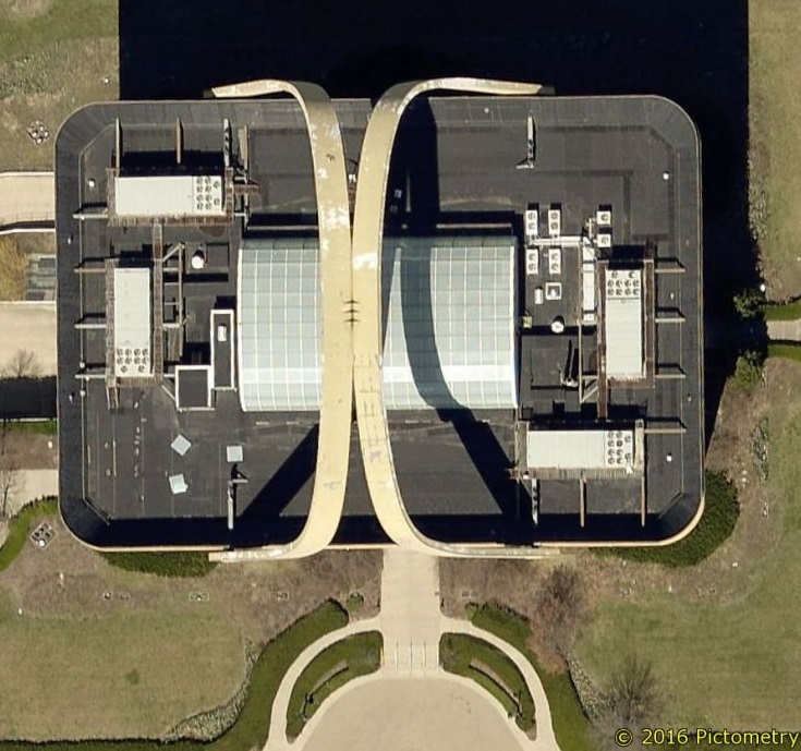
Take this overhead shot of a building. It may look like an ordinary building. However, it’s difficult to tell what those arches are over the top.
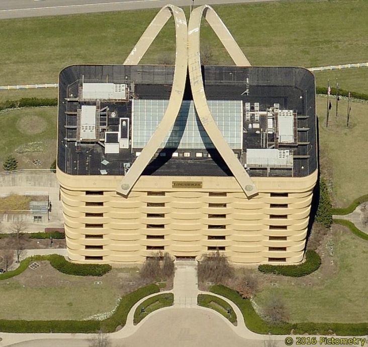
An oblique image reveals that it’s the former Longaberger Company headquarters. (The building also doubles as the world’s largest basket, for those who are interested in kitschy roadside attractions.)
When it comes to aerial imagery, government GIS departments tend to take a top-down approach. In other words, orthogonal imagery fits the bill when they view their town, city, or county.
While orthogonal imagery is a vital resource for all types of departments, oblique imagery is also beneficial. Oblique aerial images, which are captured from a 40- to 45-degree angle, makes object recognition easier, especially when that object can also be viewed from all four cardinal directions.
Take this overhead shot of a building. It may look like an ordinary building. However, it’s difficult to tell what those arches are over the top.
An oblique image reveals that it’s the former Longaberger Company headquarters. (The building also doubles as the world’s largest basket, for those who are interested in kitschy roadside attractions.)
 Oblique aerial imagery certainly gives a different view of the world!
Explore this typical suburban neighborhood to see how assessors, public safety communicators, and others in your jurisdiction might use oblique imagery in their daily workflow:
Oblique aerial imagery certainly gives a different view of the world!
Explore this typical suburban neighborhood to see how assessors, public safety communicators, and others in your jurisdiction might use oblique imagery in their daily workflow:
 //cdn.thinglink.me/jse/embed.js
How GIS Departments Can Change a Worldview
When it comes to aerial imagery, government GIS departments tend to take a top-down approach. In other words, orthogonal imagery fits the bill when they view their town, city, or county.
While orthogonal imagery is a vital resource for all types of departments, oblique imagery is also beneficial. Oblique aerial images, which are captured from a 40- to 45-degree angle, makes object recognition easier, especially when that object can also be viewed from all four cardinal directions.
Take this overhead shot of a building. It may look like an ordinary building. However, it’s difficult to tell what those arches are over the top.
An oblique image reveals that it’s the former Longaberger Company headquarters. (The building also doubles as the world’s largest basket, for those who are interested in kitschy roadside attractions.)
Oblique aerial imagery certainly gives a different view of the world!
Explore this typical suburban neighborhood to see how assessors, public safety communicators, and others in your jurisdiction might use oblique imagery in their daily workflow:
 //cdn.thinglink.me/jse/embed.js
(See a larger version here.)
Which departments could find use with oblique imagery? Many can benefit from this kind of visual intelligence, but some of the most common are: