Committed to ensuring that its integrity management system contains the most accurate and current information, a large gas utility serving the western United States set an aggressive, 90-day timeline to update its structure files. With 1.5 million structures located along 7,000 miles of linear transmission corridor running through a combination of rural to densely populated environments this was not a simple undertaking.
The effort was critical for the company to achieve its goal of building a state-of-the-art foundational dataset to serve as the backbone of its integrity management system.

Existing Resources
The utility had existing orthogonal aerial imagery of varying quality and resolution that was helpful and could be used for drawing basic outlines but it didn’t allow for in-depth analysis of buildings and areas. It was impossible to tell the number of stories associated with a structure and the images weren’t clear enough to determine land use.
“Our existing imagery allowed us to see that there was a building in a specific spot, but the quality wasn’t high enough that we could determine if it was being used for residential or commercial purposes,” explained the utility’s asset integrity specialist. “We sometimes could tell if there were multiple stories but couldn’t be certain. In understanding our high consequence areas, certainty is a must.”
Because the images didn’t offer sufficient views, the integrity management team would end up referencing multiple data sources to try to verify information. This practice often proved to be problematic. Relying on data from unconfirmed sources created confusion or led to more questions about a property, resulting in the need for a field visit to inspect the site and confirm data. It quickly became evident that this method would not allow the utility to meet its timeline and they needed a better solution.
Obtaining Authoritative Data Quickly
Understanding the value of authoritative data, aerial intelligence and the importance of the ability to remotely evaluate and inspect locations, the utility decided to engage
EagleView imagery (formerly Pictometry), a leading technology provider of aerial imagery, data analytics and GIS solutions, to provide high resolution imagery and a complete dataset of high consequence areas along its corridor. Every pixel in an EagleView image is georeferenced, meaning the image becomes actionable, allowing for measurements and data extraction.
In order to stay within the utility’s tight, 90-day timeframe, planes were dispatched to the area and high-resolution, four-inch ground sample distance oblique images were obtained of the corridor. Oblique images are those taken from a 45-degree angle and capture the north, south, east and west views of every structure utilizing the company’s USGS-certified Pentaview camera system.
“Within our 90-day timeframe we had received all of the images as well as the building outlines,” said the asset integrity specialist. “Had we continued to use our existing imagery and multiple data sources, we’d still be sifting through the information and scheduling field inspections. The oblique views gave our team a clearer understanding of the structures, their use and even the number of stories. The tools and data were a valuable resource to extract measurements and data.” The utility’s integrity management team used the EagleView images and data as a single, complete and authoritative source to eliminate inconsistencies and meet the utility’s regulatory requirements.
The team accessed the imagery and suite of measurement tools through the
ConnectExplorer platform, a web-based application offering access through any web browser. “The ability to interact with the images and outlines through the web really made it easy to distribute the data throughout the organization,” noted the asset integrity specialist. “The team was able to complete a thorough analysis of the line from their offices.” EagleView images and data also integrate into existing software and workflows through a number of integration options and extensions. The company’s mobile app allows for data review and notations in addition to providing a visual reference for teams on the rare occasion that they need to be in the field.
Staying on Top of Change
With the help of EagleView images and datasets, the utility achieved its goal to build an accurate, state-of-the-art foundational dataset for its integrity management program. The next challenge is to put a plan in place to
monitor its HCAs and stay on top of growth and change. The utility’s service area has been projected to lead growth in its state over the next 48 years becoming one of the most populated areas in the region.
These large growth projections reinforce the need for the gas utility to put an even stronger monitoring program in place to manage changes to its HCAs and identify the existence of new ones. “We recognize that the areas we serve are the counties that will be experiencing rapid growth,” stated the asset integrity specialist. “It’s critical for us to have a solid plan in place to stay on top of the structural and environmental changes that affect our lines.”
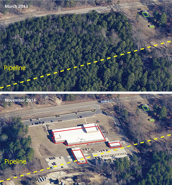
As the utility’s asset management team learned from building the foundational dataset, they need a reliable source of authoritative data to efficiently monitor change. They again turned to EagleView images and data to assist with change detection through regularly captured high-resolution imagery. EagleView is able to use the EagleView images that are captured yearly and perform a full change detection, flagging areas or structures that indicate a change.
“We decided to move forward with a system-wide capture of both orthogonal and oblique imagery,” said the specialist. “When captured on an ongoing basis it makes it easier to see what has changed over time and the flagged areas have saved our team hours and hours of time. We can quickly identify what needs further inspection.”
By utilizing a single-source, authoritative source for visualization and data that is easily shared throughout the entire organization, this western United States utility is now well positioned to manage its HCAs and entire pipeline network for years to come.


