Aerial roof measurements utilize high-resolution imagery and 3D modeling to calculate precise roof dimensions without requiring on-site measurements. Roofing contractors, insurance adjusters, and solar installers rely on this technology for faster estimates, safer inspections, and confident decisions based on verified data. Municipal assessors, real estate professionals, and construction firms also use aerial measurements to improve accuracy and reduce field risk.
Teams eliminate hours of on-site work while gaining consistent accuracy at scale by replacing manual measurements with aerial intelligence. Instead of relying on variable field conditions, crews can base their bids and designs on objective data captured from above. This shift is transforming how property professionals plan, verify, and deliver projects, especially for insurance claims after a storm.
Aerial roof measurement reports also create a single source of data across departments and partners. The result is a measurable improvement in speed, safety, and profitability across every workflow that touches a roof.
In this post, you’ll learn how aerial roof measurements work, which industries rely on them most, and how the new level of data accuracy helps teams continually grow.
What Are Aerial Roof Measurements and Why They Matter
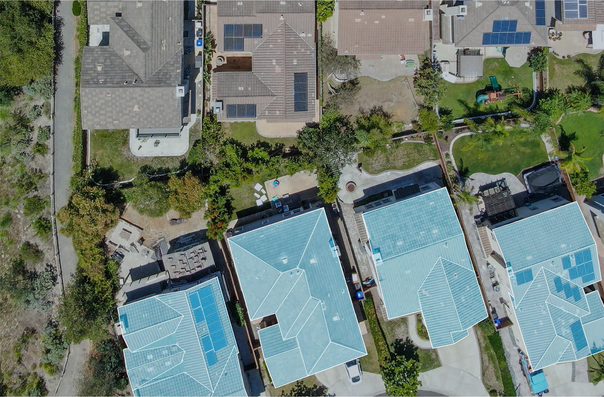
Aerial roof measurements are property dimensions derived from high-resolution orthogonal (top-down) and oblique (angled) imagery. Instead of climbing a ladder or using tape and chalk, teams receive digital measurement reports with verified square footage, pitch, and facet-level detail.
Each measurement is generated from imagery captured by specialized aircraft or drones equipped with advanced cameras. That data is processed through 3D modeling and AI-powered detection systems that identify every roof facet, ridge, and slope with pinpoint accuracy.
The result is a complete digital roof model you can use for estimates, claims, or solar design. The data is delivered remotely, so you’re getting the data in a shorter amount of time.
How Aerial Roof Measurements Deliver Accurate, Verified Roof Data
The process begins with high-resolution aerial imagery. A system like Eagleview’s captures data points with up to 1-inch ground sampling distance. From there, AI and photogrammetry software translate imagery into detailed geometry data.
1. Imagery capture: Aircraft and drones collect orthogonal and oblique photos across multiple angles.
2. Data extraction: Roof features such as pitch, area, ridgelines, valleys, hips, and eaves are detected and measured automatically.
3. 3D modeling: Software builds a full roof digital twin, accurate to within inches.
4. Report delivery: Measurements are compiled into an easy-to-read format compatible with estimating, claims, and project management tools.
5. Component identification: The system catalogs penetrations (chimneys, vents, skylights), edge metal lengths, drip edge requirements, flashing locations, and material surface areas.
6. Perimeter measurements: Total perimeter length for each roof section and the entire structure is calculated for accurate material ordering.
7. 3D modeling: Software builds a full roof digital twin, accurate to within inches.
8. Report delivery: Measurements are compiled into an easy-to-read format compatible with estimating, claims, and project management tools.
This automated process eliminates unnecessary site visits so you can scale your workflow without sacrificing precision or safety.
Why Accuracy Matters in Aerial Roof Measurement and Project Planning
Every step and measurement in a project affects time, materials, and profit. A few inches of error can mean thousands in lost revenue or disputed claims.
High-resolution aerial imagery, advanced photogrammetry, and AI modeling allow roof measurements to be verified down to the inch. This precision helps eliminate guesswork from estimates and claims while ensuring consistency across every project.
Accuracy reduces rework and prevents costly overages when ordering materials. It also provides defensible documentation and helps resolve claims faster. For solar professionals specifically, it ensures system designs align perfectly with real-world roof dimensions, preventing redesigns and change orders later. For example, Manitoba Assessment saw several benefits in using Eagleview’s aerial technology:
- ROI and Cost Efficiency: By reviewing over 18,000 properties annually using aerial imagery, Manitoba Assessment generated about $1.3 million in annual tax revenue at a cost of roughly $140,000 per year, resulting in a 900%+ return on investment.
- Operational Efficiency and Accuracy: Remote imagery-based reviews reduced the time, cost, and travel required for on-site inspections. Assessors could identify property changes and unpermitted improvements directly from their desks.
- Improved Employee Safety and Satisfaction: Staff no longer needed to drive or inspect in hazardous winter conditions. The ability to conduct desktop assessments boosted morale, reduced field risk, and improved overall job satisfaction.
When teams can rely on data instead of manual judgment, they gain the confidence to plan, bid, and verify with measurable precision.
Key industries using aerial roof measurements for accuracy and speed
Roofing contractors
Roofing professionals use aerial roof measurements to prepare bids faster and reduce field risk. Detailed roof geometry, slope, and waste factor data make it possible to generate takeoffs in minutes rather than hours.
Insurance carriers and adjusters
Insurance teams depend on aerial roof measurements to validate claims efficiently and safely. High-resolution imagery and automated damage detection tools allow adjusters to review roof conditions remotely, reducing inspection time and exposure to unsafe environments.
Solar installers
For solar professionals, aerial roof measurements deliver the data needed to design photovoltaic (PV) systems precisely. Verified roof dimensions, tilt, and obstruction data allow designers to optimize panel placement and improve production estimates.
Improving Safety and Reducing Risk with Aerial Roof Measurements
One of the larger benefits of using aerial roof measurements is being able to improve safety.
Roof inspections are among the most hazardous tasks in construction and insurance work. Slips, unstable surfaces, and unpredictable weather increase the likelihood of falls and injuries every year. Aerial imagery technology removes those risks by allowing teams to capture measurements and condition data without stepping onto the roof.
Instead of sending crews onto steep or damaged surfaces, professionals can analyze high-resolution images from a desktop or tablet. This approach not only keeps employees out of harm’s way but also reduces liability and compliance concerns tied to workplace safety standards.
Remorse aerial roof measurement also limits property damage and disruption. No ladders on siding, no scuffing shingles, and no need to coordinate multiple site visits. Whether for claims assessments or large commercial bids, teams can collect the same data with none of the physical risk.
Integrating Aerial Roof Measurements Into Your Team’s Workflow
Aerial roof measurements become part of your digital workflow when integrated correctly. The most effective systems feed measurement data, imagery, and property attributes directly into the tools your team already uses for estimating, claims, or asset management.
When aerial measurement data connects automatically to estimating software, customer relationship management (CRM) systems, or project dashboards, teams no longer have to toggle between programs or re-enter values by hand. Dimensions, area calculations, and imagery appear where they’re needed most: inside bids, work orders, or inspection summaries.
This kind of automation transforms how teams communicate. Estimators can see the same verified data as field crews and claims managers, reducing back-and-forth emails and misaligned updates. Project leads gain real-time visibility into active jobs, and decision-makers can compare productivity across offices or contractors without chasing down reports.
Integrated aerial data also supports quality control and documentation. Every measurement is traceable back to verified imagery, making it easier to validate estimates, audit claims, or maintain compliance records.
That means:
- Instant access to verified roof data within your existing platforms
- Centralized visibility across departments and locations
- Consistent, accurate handoffs from bid to build to billing
When property intelligence flows automatically between systems, teams eliminate duplicate data entry and reduce manual errors while reclaiming valuable time that can be reinvested into higher-value work.
Through connected platforms like Eagleview One™, aerial roof measurements integrate seamlessly into these workflows.
The table comparison below highlights how integrating aerial roof measurements into existing systems eliminates repetitive tasks and improves consistency across teams.
| Stage | Manual Approach | Aerial Measurement Workflow |
| 1. Data Collection | Physical site visits with ladders and tools | Imagery captured remotely from aircraft or drones |
| 2. Measurement | Manual tape/laser measurement | Automated 3D modeling and photogrammetry |
| 3. Verification | Subjective visual confirmation | Multi-angle imagery validation |
| 4. Documentation | Paper notes or local files | Digital, shareable reports |
| 5. Integration | Disconnected systems | API-connected platforms (Eagleview One™) |
What Teams Gain When They Start Using Aerial Roof Measurements
Eagleview’s measurement technology gives teams precision.
The platform elevates aerial roof measurements with more than 3.5 billion high-resolution aerial images and an accuracy rate exceeding 98%. Plus, data captured once is accessible across every stage of the project, creating viewable data points that drive efficiency and consistency.
From takeoffs to claims, Eagleview helps you work faster and smarter with measurable results:
- 98%+ verified measurement accuracy
- 3.5 billion high-resolution images in the Eagleview library
- 24 of the top 25 insurers rely on Eagleview reports
- $6.89 billion in cumulative customer savings from measurement accuracy
What sets Eagleview apart is the ability to integrate aerial intelligence directly into everyday workflows. Whether accessed through Eagleview One™, API integrations, or custom reporting, the data works where your team already operates.
With industry-trusted data, seamless integration, and scalable performance, Eagleview delivers the reliability your teams need to plan and verify with verifiable data.
Aerial measurements have reshaped how teams work. What used to require a ladder and hours on-site can now be accomplished in minutes, with verified data that can be used anywhere. This new process comes with cleaner workflows and more time to focus on the work that matters.
Request a demo and start building every project on reliable roof data.
FAQ
What are aerial roof measurements?
Aerial roof measurements are digital property measurements generated from high-resolution aerial imagery and 3D modeling. They eliminate the need for manual measuring while improving accuracy and efficiency.
How accurate are aerial roof measurements?
With Eagleview’s proprietary photogrammetry and AI-driven modeling, roof dimensions are verified at 98%+ accuracy, ensuring defensible estimates and claims.
Which industries benefit most from aerial roof measurements?
Roofing contractors, insurance adjusters, and solar installers all use aerial measurements to streamline estimates, inspections, and design.
How quickly can reports be generated?
Most Eagleview reports are delivered within hours, giving you near real-time access to verified roof data and imagery.
Can aerial roof measurements integrate with estimating or claims software?
Yes. Through the Eagleview One™ platform, measurements and imagery connect directly into your existing systems for seamless workflow automation.
Can Eagleview data integrate with my existing software?
Yes. Aerial roof measurements and imagery connect directly to estimating, claims, and project-management tools. That means no manual entry.
What safety benefits does Eagleview provide?
By replacing on-site climbs with remote imagery and measurement reports, Eagleview eliminates the most dangerous part of roof inspection work.
What ensures Eagleview’s data accuracy and reliability?
Every Eagleview measurement is derived from proprietary aerial captures and verified through 3D photogrammetry. Data is cross-checked using multiple oblique and orthogonal angles to confirm precision before it’s released in reports or APIs.
Can Eagleview scale for large or multi-site projects?
Yes. Eagleview’s cloud-based platform allows organizations to process hundreds or thousands of properties simultaneously. Teams can centralize imagery, measurements, and reports across entire portfolios without performance loss.