As a property value assessment professional, you may be responsible for assigning value to thousands or even millions of parcels in your jurisdiction. Therefore, it’s no surprise that this work can present several unique challenges.
Barriers to property value assessment
The
typical workflow of an assessor is, perhaps, the biggest obstacle in conducting timely assessments. Assessment departments will send out representatives to inspect each and every parcel on the tax roll, usually at least once every few years.
An assessor may have a jurisdiction of hundreds or even thousands of square miles, rendering the cost of travel high. Meanwhile, the reward for reaching that destination could be low. In rural counties, assessors might drive many miles only to be met with a locked gate or
other obstruction on a property. Therefore, since they can’t assess what they can’t see, the journey across the county could prove to be a waste of those resources.
But what some assessment officials may not know is that there is a better way to see properties than traveling from parcel to parcel. Advances in technology can help assessors see properties in their jurisdictions and track changes over time. This, in turn, saves them the trouble of driving from parcel to parcel, cards in hand.
What do other assessors have to say about technology?
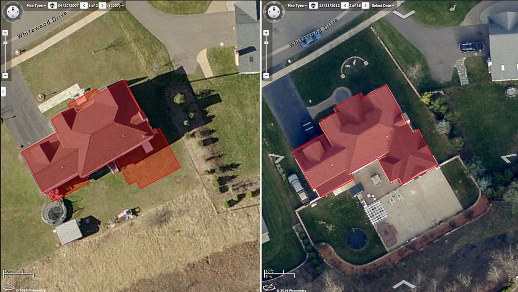
EagleView offers a number of solutions for assessment officials. Our CONNECTAssessment™ application with ChangeFinder™ data finds year-over-year changes displayed in Pictometry® aerial imagery.

An example of ChangeFinder data seen in CONNECTAssessment.
spoke about the
common challenges assessors face in the field and what technology can do about them. “We spend a lot of time in the field collecting data, monitoring demolitions and new construction,” he said. “However, because of our staffing limitation we can’t be on top of every property. ChangeFinder and CONNECTAssessment allow us to continue to inspect a large portion of our jurisdiction in a cost-effective manner without necessarily having to go to the field.”
Growing counties need to stay on top of improvements and new construction. Jason Cockerill, assessor for Washington County, Indiana, said that
technology makes it easier to see changes over time. “We believe that the aerial imagery and ChangeFinder data are essential in staying current to the construction and remodeling that is happening throughout the county,” he said.
Assess your property value assessment department’s workflow
Does your organization need a better workflow? Take this assessment to find out where your process could use some refining.
Are you a property value assessment all-star? Don’t forget to share on social media to see how your colleagues stack up.