Aerial imagery provides GIS managers and other professionals with a realistic bird’s eye view of a region. However, it can’t always tell the full story. While an aerial image may present a realistic representation of the Earth, it can’t always portray things like elevation data accurately. Looking at
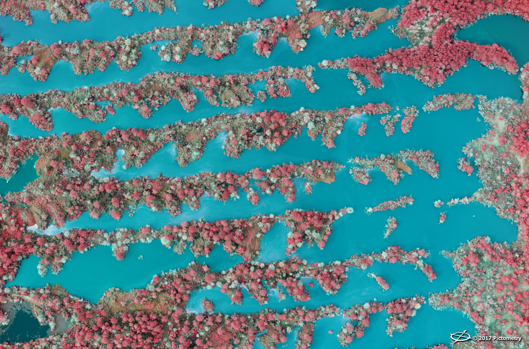
LiDAR data, which uses laser technology, is one way to obtain information about terrain and land cover. Yet there are other ways to gain information about the land around us and classify the surfaces, vegetation, and other details on the ground. One of these ways is the use of Near Infrared imagery.
The human eye can only see visible light in the electromagnetic spectrum. This is because the receptors, or cones, in our eyes can see colors in the red, green, and blue spectrums. However, there are ways for humans to “see” what we can’t: ultraviolet (UV) rays, X-rays, Gamma Rays, infrared, microwaves, and radio waves.
When it comes to the infrared spectrum, just outside of visible light, multispectral cameras capture what the human eye can’t see. These cameras capture Near Infrared (NIR) frequencies in order to classify the vegetation, impervious surfaces, and other features present in the photographs.
Near Infrared serves a number of purposes. Namely, as aerial images, they allow for visual identification of vegetation presence and health. GIS, agriculture, and local government agencies rely on NIR to detect vegetation, impervious surfaces, pollution, and other features.
 Vegetation and Crop Inventory
A vegetation inventory helps those in GIS and other industries quantify and classify the vegetation in a particular area. An example of this is the vegetation inventory from the National Park Service, which classifies, describes, and maps the vegetation communities in U.S. national parks. Public works employees, GIS managers, surveyors, engineers, and other local leaders may need to know about the presence of vegetation to reduce encroachments on power lines or pipelines. Excess vegetation can also
pose other hazards, such as increasing the likelihood of a wildfire or providing cover for persons committing vandalism and other illegal activities.
By using aerial imagery, Near Infrared, and remote sensing technologies, local GIS departments and larger government agencies save time on field visits and manual methods of classification. The agriculture industry uses NIR to assess crop health and determine the quantities of each type of crop.
State and federal agencies, as well as private industries, depend on NIR to study and map the plants and soil. This includes all types of vegetation, from forest flora on public lands to crops on large-scale farms.
 Wetland Delineation
Wetlands are some of the most diverse ecosystems in the world; they include marshes, swamps, bogs, and other areas that are saturated with ground or surface water but still support plant life and certain animal species. The presence of wetlands can improve water quality and control erosion. These regions also serve as a natural habitat for animals and support biodiversity.
To promote the conservation of these areas, government and environmental agencies will use a process called wetland delineation. In order to be classified as a wetland, an area must have hydric soils,
hydrophytic vegetation, and
hydrology.
Agencies performing wetland delineation use this criteria to mark the boundaries of the wetland. They also rely on aerial maps and imagery, as well as NIR, to collect data. Solutions like NIR and orthogonal aerial imagery give agencies the tools to classify and support such areas.
 Impervious Surface Mapping
Most urban and suburban areas won’t have acres of crops or miles of wetlands. They do, however, have more impervious surfaces. These surfaces, impenetrable by water, include paved surfaces (such as roads, sidewalks, driveways, and parking lots) as well as rooftops and compacted soil.
In many areas, local governments need to calculate stormwater runoff for each property based on the impervious surfaces. Some agencies see the number of impervious surfaces as an overall sign of a region’s environmental health, as these paved surfaces can have some devastating environmental effects.
According to one study, impervious surfaces can decrease water quality, fish populations, and groundwater reserves; they also increase the likelihood of habitat fragmentation, flooding, and
urban heat island effects.
The data obtained from Near Infrared images goes hand-in-hand with environmental causes. NIR allows jurisdictions to more easily calculate the presence of impervious surfaces. This, in turn, helps them assess the correct amount of taxes or fees to offset the costs of environmental remediation.
Near Infrared from EagleView
EagleView now offers Four-Band Imagery. This includes the standard RGB bands along with Near Infrared, as an add-on for high-resolution orthomosaic Pictometry® AccuPLUS® imagery. Curious about our Pictometry AccuPLUS solution? See it in action by downloading a copy of our Pictometry AccuPLUS Portfolio.