TL;DR: Aerial mapping captures images from above and processes them into measurable 2D maps, 3D models, and property data. The technology relies on high-resolution cameras, GPS positioning, and photogrammetry software. Different capture methods (drones, manned aircraft, and satellites) serve different project scales and accuracy requirements. This guide explains the technology, compares approaches, and shows how construction, surveying, and property assessment teams use aerial mapping to reduce site visits, order materials accurately, and make decisions with verified data.
What Is Aerial Mapping?
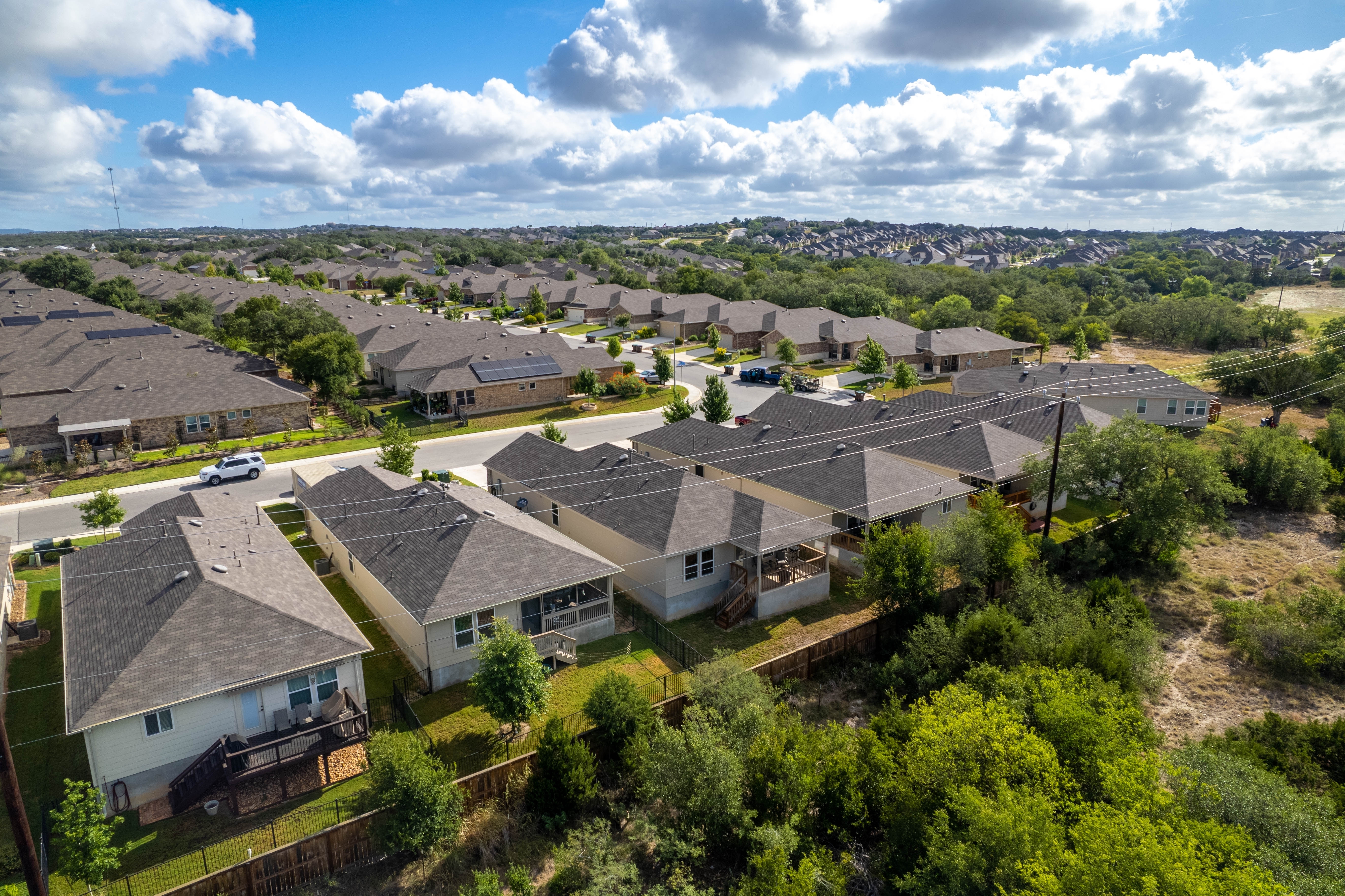
Aerial mapping (also called aerial surveying) captures images and data from above using drones, manned aircraft, or satellites, then processes them into usable geographic information. The outputs include:
- Orthomosaic maps: Geometrically corrected 2D images where every pixel is accurately positioned and measurements can be taken directly
- 3D models: Digital representations of terrain, structures, and property features with height and depth data
- Topographic surveys: Detailed elevation maps showing contours, grades, and terrain features
- Property measurements: Precise dimensions of roofs, walls, driveways, pools, and other structures
What distinguishes aerial mapping from aerial photography is measurability. A photograph shows you what something looks like. An aerial map provides precise measurements of dimensions, area, and position. That data supports calculations, not just visualization.
Modern aerial mapping systems capture everything from a single construction site to entire municipalities in one campaign. The scale depends on the capture method and the resolution requirements of the project.
How Aerial Mapping Works
Aerial mapping combines three core technologies: image capture, positioning, and photogrammetric processing.
Image Capture
High-resolution cameras mounted on aircraft capture overlapping images of the target area. The overlap is critical. Typically, 60-80% between adjacent images; this overlap gives photogrammetry software the common reference points needed to stitch images together accurately.
Two image types serve different purposes:
- Orthogonal (nadir) imagery: Camera points straight down. Produces top-down views ideal for measuring area, creating basemaps, and analyzing land use.
- Oblique imagery: Camera points at an angle (typically 40-45 degrees). Captures building facades, roof slopes, and vertical surfaces that nadir imagery misses.
Image resolution is measured in ground sample distance (GSD), the real-world size represented by a single pixel. A 1-inch GSD means each pixel covers one square inch on the ground. Higher resolution (smaller GSD) reveals finer detail but requires more flight time and processing.
GPS Positioning
Every image is tagged with precise GPS coordinates and altitude data. This georeferencing ensures that features in the final map appear in their correct real-world positions.
High-accuracy applications use differential GPS or real-time kinematic (RTK) positioning, which corrects satellite signals using ground reference stations. RTK systems achieve centimeter-level accuracy, which is critical for surveying, construction layout, and engineering applications.
Photogrammetric Processing
Photogrammetry software analyzes overlapping images to calculate the 3D position of every visible point. The process works by:
- Feature matching: Identifying common points across multiple overlapping images
- Triangulation: Calculating the 3D coordinates of each point based on its position in multiple images and the known camera positions
- Surface reconstruction: Connecting points into a continuous 3D surface
- Orthorectification: Correcting for terrain displacement and camera angle to produce geometrically accurate 2D maps
The result is a dataset where distances, areas, and elevations can be measured directly. These values are calculated from known coordinates, not estimated from a photograph.
Comparing Aerial Mapping Approaches
Three primary platforms capture aerial imagery, each with distinct advantages and limitations.
Drones (UAS)
Best for: Projects under 400 acres requiring rapid turnaround and high resolution
Drones excel at detailed site-level mapping. They fly lower than manned aircraft (typically 200-400 feet), capturing imagery at sub-inch GSD. A skilled operator can map a 50-acre site in under an hour and deliver processed data the same day.
Advantages:
- Highest resolution (sub-inch GSD achievable)
- Rapid deployment and turnaround
- Lower cost for small areas
- Can fly under cloud cover
Limitations:
- Regulatory restrictions limit flight altitude and line-of-sight requirements
- Battery life constrains coverage area (typically 20-40 minutes per flight)
- Weather-sensitive (wind, rain)
- Requires FAA Part 107 certification and airspace authorization for commercial operations
Typical outputs: Site surveys, construction progress documentation, stockpile measurements, roof inspections
Manned Aircraft
Best for: Large-area coverage (counties, municipalities, utility corridors) with consistent quality
Fixed-wing aircraft capture imagery at scale. A single flight can cover hundreds of square miles, producing consistent data across an entire region. Flight altitudes of 5,000-15,000 feet balance resolution with efficiency.
Eagleview operates a fleet of fixed-wing aircraft equipped with proprietary camera systems that capture both orthogonal and oblique imagery simultaneously. With 15+ years of aerial capture experience and 50+ patents, this approach produces 1-inch GSD imagery across large coverage areas, 70x higher resolution than typical satellite imagery.
Advantages:
- Large-area coverage in single campaigns
- Consistent quality across entire regions
- Higher altitude means fewer weather disruptions than drones
- Oblique capture provides building facade views
Limitations:
- Higher mobilization costs than drones
- Longer turnaround than on-demand drone flights
- Requires flight planning and airspace coordination
Typical outputs: County-wide basemaps, property assessment imagery, insurance portfolio data, utility corridor mapping
Satellite Imagery
Best for: Continental or global coverage where resolution is secondary to scale
Satellites capture imagery across vast regions, making them useful for broad geographic analysis, change detection over time, and applications where moderate resolution suffices.
Advantages:
- Global coverage
- Historical archives enable change analysis
- No flight planning or airspace authorization required
Limitations:
- Lower resolution (typically 30cm-1m GSD for commercial satellites)
- Cloud cover blocks imagery
- Fixed orbital paths limit capture timing
- Oblique views not available
Typical outputs: Land use analysis, agricultural monitoring, large-scale change detection
Resolution Comparison
| Platform | Typical GSD | Coverage per Mission | Turnaround | Accuracy Verification |
| Drone | 0.5-2 inches | 50-400 acres | Same day | Varies by operator |
| Manned aircraft | 1-6 inches | 100-500+ square miles | Days to weeks | Independent testing available |
| Satellite | 12-40 inches | Continental | Varies by provider | Limited |
The right choice depends on project scale, resolution requirements, and timeline. Many organizations use multiple approaches: satellite imagery for broad monitoring, manned aircraft for regional coverage, and drones for detailed site work.
Aerial Mapping Applications by Industry
Any industry needing accurate spatial data without ground crews benefits from aerial mapping.
Construction
Construction teams use aerial mapping throughout the project lifecycle:
Site planning: Before breaking ground, aerial maps provide accurate existing conditions data: topography, drainage patterns, vegetation, and neighboring structures. This baseline informs design decisions and identifies potential issues before they become expensive problems.
Progress tracking: Regular aerial captures document construction progress. Comparing current conditions to design plans reveals whether work matches specifications. Project managers can verify earthwork quantities, track building footprints, and identify schedule delays without walking the entire site.
As-built documentation: Final aerial surveys create permanent records of completed construction, useful for maintenance planning and future modifications.
Practical example: A general contractor uses drone mapping to verify earthwork quantities before approving subcontractor invoices. The aerial survey calculates cut/fill volumes to within 1-2% of actual, accurate enough to catch discrepancies that would otherwise require expensive re-measurement or disputes.
Surveying and Engineering
Aerial mapping extends the reach of survey crews:
Topographic mapping: Traditional ground surveys require crews to physically occupy each measurement point. Aerial photogrammetry captures thousands of points per second, producing detailed topographic maps of areas that would take ground crews weeks to survey.
Corridor mapping: Utilities, pipelines, and transportation projects span miles of terrain. Aerial mapping streamlines corridor capture, producing the elevation data engineers need for design and the imagery planners need for environmental review.
Inaccessible terrain: Steep slopes, wetlands, and hazardous sites that are difficult or dangerous for ground crews can be mapped from the air without safety risk.
Accuracy note: Aerial photogrammetry is a proven method that achieves vertical accuracy of 1-3x the GSD under good conditions. For a 2-inch GSD capture, expect 2-6 inches of vertical accuracy. Ground control points improve accuracy further. Survey-grade applications may still require ground verification of critical points.
Property Assessment and Insurance
Property assessors and insurance professionals use aerial mapping to evaluate properties without site visits:
Roof measurements: Aerial imagery and photogrammetry produce accurate roof dimensions (pitch, area, and material identification) without sending anyone onto the roof. Roofing contractors use these measurements to generate accurate material orders and bid estimates.
Property condition assessment: Oblique imagery reveals building facades, roof condition, vegetation encroachment, and property features that nadir imagery misses. Underwriters use this information to assess risk; adjusters use it to evaluate claims.
Portfolio analysis: When imagery covers entire regions, insurers can analyze their full book of business, identifying properties with specific risk factors, verifying policy details, and prioritizing inspections.
Eagleview property reports deliver roof and exterior measurements with 98.77% accuracy (independently verified by CompassData). A typical residential report includes roof dimensions, pitch, materials, and a complete material takeoff, delivered in 3-6 hours.
Government and Public Agencies
Local governments rely on aerial mapping for:
Tax assessment: Accurate property data ensures fair taxation. Aerial imagery identifies new construction, additions, and property improvements that might otherwise go unrecorded.
Planning and zoning: Current aerial imagery supports land use planning, zoning enforcement, and development review. Planners can verify setbacks, lot coverage, and compliance without site visits.
Emergency response: After disasters, aerial imagery documents damage across affected areas. Emergency managers use this information to prioritize response, and assessors use it to calculate lost property value.
The Aerial Mapping Workflow
The workflow below covers timeline, accuracy, and deliverables.
1. Flight Planning
Every aerial mapping project starts with planning:
- Define the area of interest: Boundaries, buffer zones, and any no-fly areas
- Determine resolution requirements: What GSD is needed for the intended application?
- Plan flight lines: Calculate altitude, speed, and overlap to achieve target resolution
- Check airspace: Obtain necessary authorizations for controlled airspace
- Assess weather windows: Cloud cover, wind, and lighting conditions affect image quality
For large-area manned aircraft captures, flight planning may begin weeks in advance. Drone operations can often plan and execute within days.
2. Image Capture
Capture quality determines final accuracy. Key factors:
Altitude: Lower altitude produces higher resolution but requires more flight lines to cover the same area. The relationship is direct: halving the altitude doubles the resolution but quadruples the number of images needed.
Overlap: Higher overlap improves accuracy and reduces gaps but increases flight time and data volume. Standard overlap is 60% forward (along flight lines) and 30% side (between flight lines). High-accuracy applications may use 80% or higher.
Lighting: Consistent lighting produces the best results. Midday sun creates harsh shadows; overcast conditions provide even illumination but may reduce contrast. The ideal window is typically mid-morning or mid-afternoon on partly cloudy days.
Weather: Wind affects aircraft stability and image sharpness. Rain and fog degrade image quality. Most operations require visibility of 3+ miles and winds under 15-20 mph.
3. Data Processing
Raw images become usable maps through processing:
Quality review: Check images for blur, exposure problems, and gaps in coverage. Poor-quality images are flagged or re-captured.
Photogrammetric processing: Software matches features across images, calculates point positions, and generates outputs. Processing time scales with data volume. A small drone survey might process in hours; a county-wide capture may take days.
Ground control integration: For the highest accuracy, ground control points (surveyed reference markers) are incorporated into the adjustment, tying the aerial data to known coordinates.
Product generation: Final outputs (orthomosaics, 3D models, contours, measurements) are extracted from the processed dataset.
4. Quality Assurance
Accuracy verification confirms the data meets specifications:
- Positional accuracy: Do features appear in their correct locations?
- Measurement accuracy: Do calculated distances match actual dimensions?
- Completeness: Are there gaps, shadows, or obscured areas?
Independent accuracy testing, like Eagleview's verification by CompassData, provides confidence that measurements can be trusted for downstream applications.
5. Delivery and Integration
Final products are delivered in formats that integrate with users' existing systems:
- GIS formats: GeoTIFF, shapefile, geodatabase for mapping and analysis software
- CAD formats: DXF, DWG for engineering and design applications
- Web platforms: Cloud-based viewers for browser access without specialized software
- API integration: Direct data feeds into enterprise systems (claims platforms, asset management, etc.)
Factors That Affect Aerial Mapping Accuracy
Aerial mapping accuracy isn't absolute. It depends on capture conditions, processing methods, and the intended application.
Ground Sample Distance
GSD sets the theoretical resolution limit. You can't reliably measure features smaller than a few pixels. For roof measurements, a 1-3 inch GSD captures individual shingles and flashing details. For land use mapping, 6-12 inch GSD suffices.
Image Quality
Blur, haze, shadows, and overexposure degrade accuracy. The best capture conditions produce sharp, evenly lit images with consistent color balance across the entire area.
Ground Control
Ground control points (surveyed markers visible in the imagery) anchor the aerial data to known coordinates. Without ground control, positional accuracy depends entirely on GPS, which introduces error. With well-distributed ground control, accuracy improves significantly.
Terrain and Vegetation
Flat, open terrain maps most accurately. Steep slopes, dense vegetation, and complex structures create challenges:
- Steep terrain: More geometric distortion to correct
- Vegetation: Canopy obscures ground surface; leaf-off conditions improve terrain accuracy
- Complex structures: Multiple roof levels, overhangs, and vertical surfaces require oblique imagery for complete capture
Processing Parameters
Software settings affect output quality. Aggressive noise reduction smooths detail; insufficient tie points create distortions. Experienced processors balance these tradeoffs based on the data quality and intended application.
Getting Started with Aerial Mapping
Before investing in aerial mapping, answer these questions:
- What decisions will this data support? Clarity on the end use determines resolution, accuracy, and update frequency requirements. Roof measurements for material ordering need sub-inch accuracy. Regional land use planning may tolerate lower resolution.
- What area do you need to cover? Site-level projects favor drones. Regional coverage requires manned aircraft. National analysis may use satellite imagery.
- How current does the data need to be? Some applications need imagery captured within days of a specific event (post-storm damage assessment). Others can use imagery that's months or years old (baseline property data).
- How will you use the data? Integration requirements matter. If the data feeds into existing GIS, claims, or engineering systems, confirm format compatibility before capture.
For organizations that need property intelligence at scale, options range from individual roof reports delivered in hours to enterprise platforms covering millions of properties. Eagleview's 3.5+ billion image library covers 94% of the U.S. population, with 1-inch GSD resolution and independently verified accuracy.
Whether you're bidding roofing jobs, assessing insurance claims, or maintaining government property records, aerial mapping turns what used to require site visits into data you can access from your desk.
Contact us to get a sample property report and see what 98.77% measurement accuracy looks like for any address in our coverage area.
FAQ
How accurate is aerial mapping?
Accuracy depends on resolution, ground control, and processing quality. Drone mapping at 1-inch GSD achieves 2-6 inches of vertical accuracy. Manned aircraft with professional-grade equipment and ground control can achieve sub-inch horizontal accuracy. Eagleview's measurements are independently verified at 98.77% accuracy by CompassData.
How much does aerial mapping cost?
Costs vary by project scope and method. Drone mapping for small sites (under 50 acres) typically runs $500-2,000 per project. Manned aircraft captures for regional coverage cost more upfront but deliver lower per-acre costs at scale. Per-property roof reports from established providers range from $15-50 depending on detail level and turnaround time.
What's the difference between aerial mapping and aerial photography?
Aerial photography produces visual images. Aerial mapping produces measurable geographic data. The key difference is photogrammetric processing: aerial mapping uses overlapping images, GPS data, and specialized software to calculate precise coordinates, distances, and elevations. You can measure directly from an aerial map; you can only estimate from a photograph.
How long does aerial mapping take?
Timeline depends on project size and method. A drone survey of a 50-acre site can be captured in under an hour and processed same-day. Regional manned aircraft captures covering hundreds of square miles require days to weeks from flight planning through final delivery. Individual property reports from existing imagery libraries can be delivered in 3-6 hours.
Is drone mapping the same as aerial mapping?
Drone mapping is one type of aerial mapping. Aerial mapping also includes manned aircraft and satellite imagery. Drones work well for small, detailed projects. Manned aircraft cover large areas efficiently. Satellites provide global coverage at lower resolution. Many organizations use all three methods for different purposes.