Benefits of Oblique Aerial Imagery for GIS

Learn how oblique aerial imagery can help GIS analysts support their local government’s goals.
GIS Professionals Need to Support Multiple Departments
GIS analysts are responsible for providing and managing the data that government departments need to make effective decisions, achieve their objectives, and drive new initiatives.
To accomplish this, GIS departments have typically relied on orthogonal or ortho (top-down) aerial imagery as a “map accurate” background image. Because it’s been adjusted for topographic relief, lens distortion, and camera tilt, ortho is considered an accurate representation with uniform scale of the Earth's surface, and can be used to measure true distances.
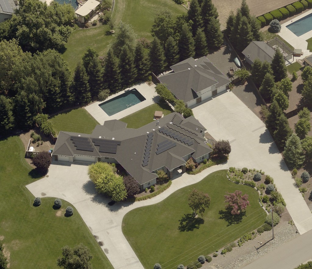
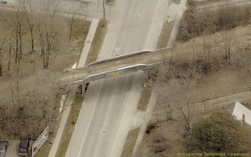
This generally works fine when trying to identify things like rooftops and street grids. But because ortho imagery only provides top-down views of structures, landmarks, and other assets, it lacks the perspective needed to determine object height and other features, or to identify details that can only be seen clearly from a side angle (e.g., street lights, signs, fire hydrants, doors, windows, walls, HVAC units, and garages).
That means that maps using only ortho imagery can’t provide the insights many departments need in order to accomplish a variety of critical tasks.
Imagine This Scenario:
- A tourist is visiting from out of town and staying at a rental house. They have a heart attack and call 911, but do not know the address of the house they are staying in. They only know the color of the house is pink. The dispatcher can identify the general area the call is coming from and visually locate the specific house by color. They can then locate the entrances to the building. This is possible by viewing the side angle of the structure on the oblique imagery.
- An assessor needs to determine whether a structure is a building with heated square footage, or only a pole barn without siding. They can view the oblique imagery to see under the roof and determine what the structure is and calculate its valuation.
- Public works staff can use oblique imagery to map assets such as light poles or hydrants —features which would be difficult to discern on an orthogonal image, and which have traditionally required time-intensive surveying in the field.

EagleView's Oblique Aerial Imagery Can Help
Oblique imagery is taken at a 40-to-50-degree angle from low flying aircraft equipped with a camera system that rapidly captures images from all perspectives, offering a clear view from all cardinal directions. These perspectives can then be served together to create a broad-scale, holistic world view.
This enables government teams to utilize ‘ground-truthing’ to remotely verify assets in the field (such as signs and traffic lights), and avoid misidentifying structural, situational, and topographical details.
By providing this level of high-resolution oblique aerial imagery and geospatial intelligence, GIS analysts help the agencies they serve to:
- Streamline their workflows.
- Get actionable intelligence.
- Set priorities.
- Make better decisions.
- Efficiently deploy assets.
- Identify geographical context, patterns, and issues.
- Monitor geographical and structural changes.
“[Oblique imagery] makes it more authoritative. Users have more confidence in what they’re seeing and it becomes something they can start relying on.”
-David Dodds, GIS Architect, Polk County IA
This guide will explore the benefits of EagleView's oblique aerial imagery for GIS, including:
- Complementing ortho imagery with additional side-angle views to provide additional perspective and cross-department utility.
- Use cases by department, providing assessment, public safety/911, emergency management, and public works with the data-driven insights needed to accomplish their goals.
- The ability to integrate oblique aerial imagery within existing workflows and software platforms (e.g. Esri, Cityworks).
- Additional visualization and analytics tools from EagleView.
1. Perspective and Cross-Department Utility
Perspective
EagleView's oblique aerial imagery offers the perspective and insights departments need to accomplish certain critical tasks, including the ability to:
- See details from a side angle—doors, windows, walls, HVAC units, garages, etc.
- Identify landmarks, lights, signs, and other assets that would be hard to clearly see from top-down ortho imagery alone.
- Accurately measure structures, assets, and distances (e.g., distance of a sign from the road) needed for confident insights.
Cross-Departmental Utility
The value of EagleView's high-resolution oblique aerial imagery spans across many government agencies—facilitating cross-departmental collaboration, cost-sharing, and greater overall efficiency.
The same image portfolio that helps GIS analysts maintain timely and reliable asset data can also help public safety teams pinpoint a 911-caller’s location, as well as enable assessors to detect property changes and provide accurate valuations.
In addition to well-known use cases (see “Use Cases by Department” below), government departments have reported using oblique aerial imagery to:
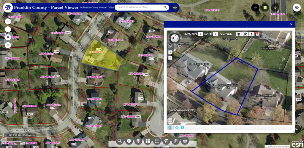
- Create and maintain parcel layers.
- Monitor land use.
- Manage zoning land use compliance.
- Facilitate remote permit inspections.
- Manage economic development and planning.
- Facilitate site planning for community events like farmers’ markets and festivals, and plan positioning of public safety assets and temporary on-site infrastructure.
2. Use Cases by Department
EagleView's oblique aerial imagery gives GIS analysts the ability to support various departments by delivering the data, imagery, and other information they need to achieve their goals.
Assessment
Assessment departments are charged with delivering a timely, equitable tax roll while keeping their teams safe and productive. Time-intensive field visits can limit efficiency, add cost, and potentially place assessors at risk.
EagleView's oblique aerial imagery helps assessors efficiently calculate the value of parcels, and stay on top of improvements and new construction.
- Leverage high-resolution property views and change detection solutions to identify additional taxable value.
- Overlay parcel data and custom GIS layers to streamline desktop assessments.
- Use oblique imagery to see all sides of a structure, measure length and height of the structure, and provide important context and detail.
Public Safety/911
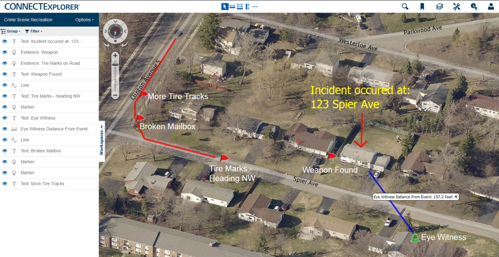
Public safety teams must respond to situations at all hours and in all conditions. Access to accurate and timely location information is crucial to their success.
GIS analysts can support public safety teams, dispatchers, and law enforcement with data layers validated using oblique aerial imagery, including:
- Accurate addressing to help first responders pinpoint a 911 caller’s location and understand the situation on the ground.
- Accident reconstruction intelligence and the ability to track and monitor locations with high concentrations of accidents or emergency calls.
- Critical site intelligence used when planning for SWAT raids, serving warrants, and identifying surveillance and staging areas.
Disaster Preparedness/Emergency Planning
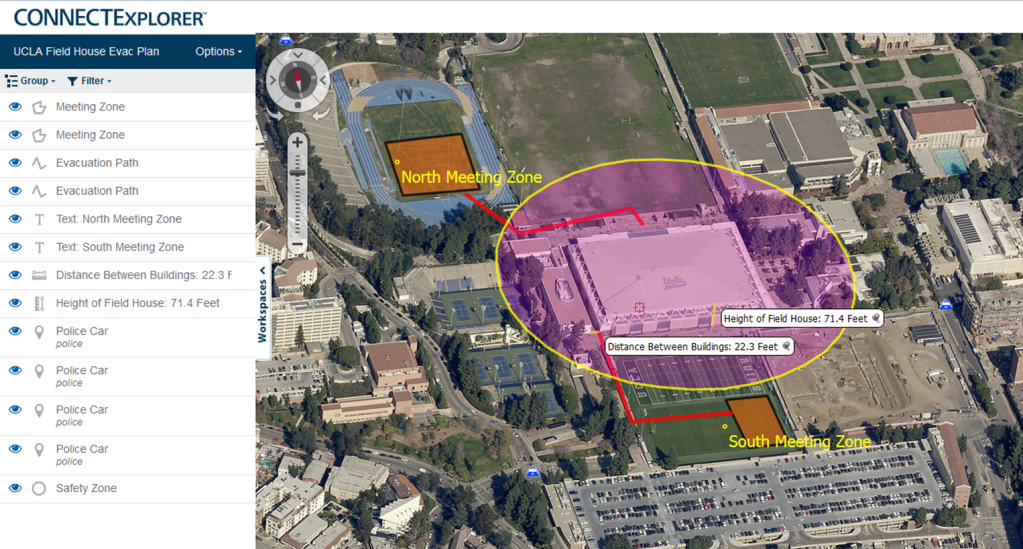
EagleView's pre- and post-event oblique aerial imagery is critical to helping public safety, emergency management, and other government agencies plan, prepare, and respond to catastrophic events.
- View both recent and historical oblique imagery with added enhancements including LiDAR, 3D Mesh, and Near Infrared capture to identify risks for flooding, vegetation conditions and wildfire risks, and other potential hazards.
- Use oblique imagery to add additional context to GIS maps, and better understand the potential impact of flooding and stormwater management.
- Quickly assess damage in the immediate aftermath of a disaster, and share oblique aerial image data when applying for recovery assistance from state and federal aid programs.
Following a natural disaster or terrorist attack, EagleView delivers critical pre- and post-event imagery. All EagleView contracts include our Disaster Response Program (DRP), which means EagleView will fly affected areas which meet certain criteria at discounted or no additional cost. EagleView’s DRP can equip emergency response teams with new imagery and data they need to assist with rescue and recovery just days after an event.
Public Works
EagleView's oblique aerial imagery reveals greater detail of structures, and provides a more complete understanding of assets without a physical inspection, helping public works teams:
- Remotely measure roads, bridges, and other key infrastructure.
- Preplan infrastructure projects and inspect field assets.
- Track, verify, and report on the status of key infrastructure components.
- Visualize environmental conditions for public assets.
3. Integrate With Your Existing Workflow
Esri Integration
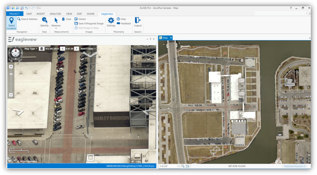
Esri users can access EagleView’s oblique and orthogonal imagery directly within the Esri platform and other data visualization tools.
- Remove the cost and complexity of third-party imagery and datasets.
- Make it easy for other departments to leverage the imagery and data alongside what they're already creating and maintaining.
- Overlay GIS data layers on both ortho and oblique imagery to provide important context.
- Enrich existing GIS layers by adding additional attributes, such as the type of siding for buildings, or the color of fire hydrants.
- Heads-up digitize assets and features on ortho and oblique imagery, and download vector layers to Shapefile or KML to import to ArcGIS.
There are countless ways to integrate EagleView into your Esri applications and third-party Esri-based applications:
- EagleView for ArcGIS Desktop, ArcGIS Pro, and Web AppBuilder Developer Edition.
- Integrate our oblique imagery into your ArcGIS Online Web Mapping Applications using our JavaScript web-based API.
- Use the EagleView ortho as a basemap in web maps, ArcGIS Online apps, and in ArcGIS Pro or ArcMap using our REST cloud-based Image Service.
- Access orthomosaics in WMS, WMTS, and TMS format.
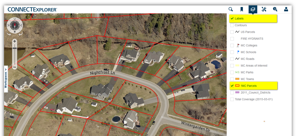
- Use EagleView CONNECTExplorer or a custom web-map creation to overlay published REST data for a powerful combination of imagery and local data.
Cityworks Integration
Government agencies rely on aerial imagery to verify assets and reveal details of critical structures—without the need for a field visit.
To help make this process even more efficient, Cityworks users in the US and Canada can view and access their high-resolution EagleView oblique and ortho imagery from within the Cityworks Esri map viewer. This enables them to:
- Increase productivity and eliminate the need to switch between multiple applications.
- Remotely identify and measure roads, bridges, and other key infrastructure.
- Collaborate within one environment with other local government departments.
4. Additional Tools
Certified Imagery With TrueTouch™
Certified Orthomosaic and TrueTouch imagery enhancements are available options for EagleView users. Orthomosaics are image maps that have been produced to accurately represent the geography of an area. They’re created by combining a collection of overlapping ortho images (aerial imagery that’s free of distortion and geometrically corrected to produce a uniform scale). An orthomosaic view allows users across government departments to easily scroll and pan across a unified image to get a more accurate and complete view, versus loading and inspecting separate individual images of an area.
EagleView also offers Certified Orthomosaic imagery, where an orthomosaic is validated for geospatial accuracy by our licensed engineering and surveying team, with the additional use of surveyed ground control, and produced in accordance with state and local requirements.
EagleView TrueTouch applies visual enhancements to critical features in the orthomosaic imagery by:
- Removing evidence of seams and distortions.
- Removing inconsistencies related to tall building lean, time of day, changes in imagery capture, cloud shadow, and a variety of other issues.
- Improving image quality, assuring positional accuracy, and providing accurate representation across all features (e.g., roads, bridges, large buildings, and landmarks).
Geospatial 3D Mesh Layers
EagleView’s partnership with Skyline offers additional ways to visualize your geospatial data using 3D mesh layers.
Government agencies use geo-referenced 3D mesh layers for urban planning, asset management, emergency response planning, tax assessments, and other critical functions.
EagleView’s high-resolution oblique imagery can be delivered with both 3DML files for viewing in Skyline’s TerraExplorer web-based GIS viewer and editor, along with SLPK files for viewing in Esri’s ArcGIS Online, ArcGIS Pro, and ArcGIS Urban platforms. Users can view scenes in 3D and use GIS tools such as viewshed and line-of-sight calculation.
- Highest Resolution—Reproduce the smallest details, including cars, trees, fences, and walls with advanced color balancing and high-quality texturing.
- Multiple Output Formats—Export in a variety of formats and resolutions, including 3” – 6” GSD, 3DML, and SLPK.
- Superior Precision—View accurate representations of intricate features, details, geometry, and color with high-quality texturing.
- Intuitive Interface—Access powerful visualization capabilities and tools, including photo projection on terrain and project preview to streamline evaluation and adjustments to parameters.
Get Started Today
To learn more about how EagleView solutions can help meet your department's needs or to request a demo, visit https://www.eagleview.com/industry/government/.