TL;DR: Urban city planning success depends on five factors: understanding the physical, social, and economic environment; involving residents through participatory planning; building for future population growth rather than just current needs; addressing urban renewal with sensitivity to historic preservation; and using modern GIS tools like high-resolution aerial imagery to make data-driven decisions. Planners who master all five factors create communities that function well for decades.
Urban planning shapes how cities grow, function, and serve their residents. Every zoning decision, infrastructure project, and community space reflects planning choices that will affect neighborhoods for generations.
Regional planners collaborate with government officials and residents to determine what an area needs now and what improvements will serve it in the future. With more than half the world's population living in urban areas, the stakes keep rising. Adding housing, revitalizing struggling neighborhoods, and preparing for population growth all require careful coordination.
The challenge is that these decisions interact in complex ways. A new transit line changes property values. A commercial development shifts traffic patterns. A park creates community gathering space but also affects stormwater management.
This guide covers the five factors that determine whether urban planning projects succeed or create new problems: environmental analysis, resident involvement, forward-looking design, urban renewal considerations, and the data tools that tie everything together.
1. Environmental Analysis Sets the Foundation
Every planning decision starts with understanding the environment where development will occur. Geography alone doesn't tell the whole story. Social dynamics and economic conditions shape what a community actually needs.
Physical Environment
Location and geology determine fundamental constraints. A coastal city in Florida faces hurricane exposure, salt air corrosion, and flood insurance requirements that don't apply to a landlocked Midwest town. Climate affects building codes, infrastructure durability, and outdoor space usage. Proximity to water sources shapes growth potential, since municipal water systems have defined capacity limits.
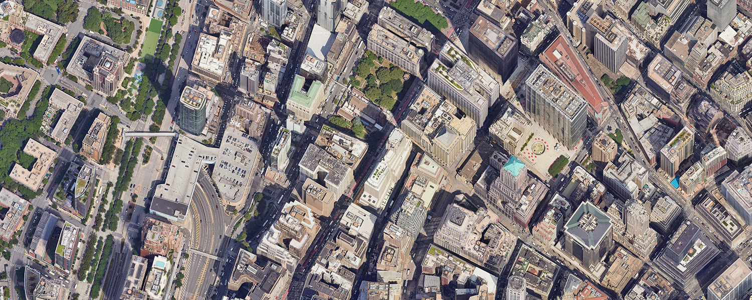
Planners work closely with GIS departments to obtain terrain mapping data that reveals what the geography actually supports. Topographic analysis identifies areas prone to runoff accumulation. Soil surveys flag locations where foundations will require deeper pilings or specialized engineering. High-resolution oblique aerial imagery lets teams view slopes, drainage patterns, and flood zones before committing to site plans. Seeing the terrain from multiple angles reveals features invisible in flat maps or orthogonal views.
Key physical factors to assess:
| Factor | Planning Impact |
| Climate zone | Building materials, HVAC requirements, outdoor space design |
| Flood risk | Site selection, stormwater infrastructure, insurance costs |
| Soil conditions | Foundation requirements, construction costs, vegetation options |
| Water access | Growth limits, utility infrastructure, recreation opportunities |
| Existing land use | Zoning changes needed, remediation costs, community expectations |
Social Environment
The existing social fabric of a community determines how residents will interact with new developments. Planners must understand which demographics use which resources, how transportation options connect neighborhoods, and where service gaps exist.
A neighborhood with many seniors has different needs than one with young families. Areas with limited public transit require different commercial zoning than walkable urban cores.
Economic Environment
Business mix, employment trends, and household income levels all affect what development makes sense. A city experiencing job losses needs different planning priorities than one attracting corporate relocations. Planners track commercial vacancy rates, business license applications, and building permit trends to understand economic momentum before it shows up in census data.
Detroit's revitalization required planning approaches fundamentally different from those used in growing tech hubs. When commercial vacancies exceed 20%, zoning that prioritizes mixed-use development and smaller retail footprints often works better than traditional commercial zones designed for single-use big-box stores. Successful planners account for these economic realities rather than applying generic templates developed for different market conditions.
2. Resident Involvement Creates Buy-In
Urban planning used to rely solely on hand-drawn plats created by architects and officials. The people who would actually live with the results had little input.
That approach failed repeatedly. In the early 20th century, planners focused so heavily on aesthetic design that they ignored how developments affected daily life. Later, cities built expressways through historic neighborhoods despite public opposition, demolishing communities in the name of progress.
Participatory Planning Works Better
Modern planning involves residents throughout the process. Participatory planning gives communities a voice in decisions that affect their property values, commute times, and quality of life.
A quaint historic neighborhood may resist big-box retail that would change its character. A rural community might welcome the same development. Only by asking residents do planners learn which approach fits.
Participatory planning also improves public awareness about what changes are coming and why. When residents understand the reasoning behind decisions, they're more likely to support implementation even when some choices disappoint them.
Methods That Build Engagement
Effective resident involvement includes:
- Community meetings where residents review proposed plans and provide feedback
- Online portals where stakeholders can see visualizations and comment
- Advisory committees that represent different neighborhood interests
- Public hearings required before major zoning changes
- Design charrettes where community members work alongside planners
The GIS and Planning departments increasingly use aerial imagery in public presentations, giving residents a bird's-eye view of how proposed changes will look in context. Seeing actual imagery communicates more effectively than abstract site plans.
3. Forward-Thinking Design Anticipates Growth
Current residents deserve consideration, but cities also need to plan for people who will arrive in five, ten, or twenty years. Looking ahead separates great planning from merely adequate planning.
Tracking Population Trends
Urban planners monitor population data to determine how much space future development requires. If population is rising and a developer proposes apartment buildings downtown, planners may push for high-rises rather than two-story buildings to accommodate expected growth.
Tourism increases call for additional hotels and event venues. Manufacturing growth requires industrial zoning and transportation access. Each trend shapes different planning priorities.
Sioux Falls, South Dakota illustrates how fast growth can occur. The population is projected to grow from 285,700 in 2022 to 428,400 by 2060, nearly a 50% increase. Planning decisions made today must accommodate that growth or the city will face housing shortages, traffic congestion, and infrastructure strain.
Minnehaha County agencies use aerial imagery to track development changes over time, identifying where growth is occurring and adjusting plans accordingly.
Planning for Outcomes, Not Timelines
Smart planners focus on specific outcomes rather than arbitrary timeframes. They know the population might grow by 100,000, but that growth could take 10 years or 30 years depending on economic conditions.
Outcome-focused planning means reserving land for eventual schools even when current enrollment is stable. Building utility infrastructure with capacity for expansion. Designing intersections that can handle more traffic without complete reconstruction.
Forward-planning considerations:
| Growth Factor | Planning Response |
| Population increase | Housing density, school capacity, park space |
| Economic development | Commercial zoning, transportation access, workforce housing |
| Aging infrastructure | Replacement schedules, upgrade paths, redundancy planning |
| Climate adaptation | Stormwater capacity, heat mitigation, resilient building codes |
4. Urban Renewal Requires Special Sensitivity
Many U.S. cities contain struggling areas that need revitalization. Renewal work can involve renovating existing structures or demolishing them to make way for new development.
Either path demands careful thought about what's being changed and what will replace it.
Historic Preservation Matters
A building in disrepair might be a historic site or local landmark. City residents often want to preserve character even when structures need significant work.
The tension between preservation and renewal played out for decades as cities demolished historic neighborhoods for expressways. State and federal efforts now protect important landmarks, but planners still navigate these tensions regularly.
The best renewal projects find ways to honor history while addressing current needs. Adaptive reuse transforms industrial buildings into housing or commercial space. Historic facades remain while interiors are modernized.
Tax Incentives Shape Options
Federal Historic Tax Credits cover 20% of qualified rehabilitation expenses for income-producing historic buildings. State programs add additional percentages in many jurisdictions. Low-Income Housing Tax Credits (LIHTC) fund affordable housing development. Opportunity Zone designations provide capital gains deferrals for investments in designated census tracts. Other incentives encourage small businesses to open in particular neighborhoods.
Planners who understand these financial tools can structure renewal projects that pencil out for developers while serving community needs. A project that seems uneconomic with standard financing might work with the right combination of historic preservation credits, LIHTC allocation, and local property tax abatement. The difference between a viable project and a failed proposal often comes down to layering the right incentives.
Disaster Recovery and Resilience
Natural disasters create acute renewal challenges. After hurricanes, floods, or wildfires, urban planners help communities rebuild in ways that reduce future vulnerability.
Recovery planning covers updating building codes, relocating development away from high-risk areas, and strengthening overall community resilience. Post-event aerial imagery helps planners assess damage and coordinate recovery efforts.
Rockport, Texas faced exactly these challenges after Hurricane Harvey. Planning professionals worked on rebuilding roads, updating codes, and ensuring the rebuilt community would weather future storms better than its predecessor.
Urban planners earn median salaries around $78,500, according to Bureau of Labor Statistics data, and that figure keeps rising as demand for sustainable urban plans grows. Most planners hold at least a master's degree.
Education matters, but tools matter too. Creating effective plans for current and future residents requires accurate data about what exists today and how it's changing.
Planners and government officials employ GIS solutions that integrate high-resolution aerial imagery with mapping data. Teams can analyze properties, measure infrastructure, and track changes without constant site visits. Modern imagery captures ground sample distances (GSD) down to 1-inch resolution, revealing details like individual vehicles, fence lines, and small outbuildings that lower-resolution sources miss.
Orthogonal imagery provides top-down views for mapping parcel boundaries and land use patterns. Oblique aerial imagery adds perspective views from multiple angles, letting planners see building heights, roof conditions, structural additions, and features invisible from directly overhead. Combining both view types gives planners complete property intelligence without site visits.
Common GIS applications in planning:
- Zoning compliance monitoring and code enforcement
- Infrastructure condition assessment
- Stormwater and drainage analysis
- Transportation network evaluation
- Population density mapping
- Environmental impact assessment
3D Models Add Depth
Three-dimensional models use up-to-date imagery and can be delivered in multiple formats. Planners visualize how new construction will fit existing neighborhoods, calculate cut-and-fill requirements for site preparation, and communicate plans to stakeholders more effectively than flat maps allow.
Beyond planning, 3D models support emergency response, terrain analysis, and subsurface infrastructure studies. Security teams use them to manage high-profile events like sports tournaments, conventions, or visits from dignitaries by modeling crowd flows and perimeters.
Remote Assessment Saves Time and Money
Traditional planning required constant site visits. Every zoning question, permit review, or compliance check meant sending staff into the field.
Modern imagery lets planners review properties remotely, reserving site visits for situations that require physical presence. Fauquier County, Virginia found that aerial imagery allowed their assessors to streamline reviews for about 75% of parcels, dramatically reducing time and cost while improving accuracy.
Better Data Leads to Better Cities
Urban planning decisions echo for generations. The street grid laid out in 1850 still shapes traffic patterns. The park created in 1920 still serves families. The zoning change approved yesterday will influence neighborhood character for decades.
With that much at stake, planners need tools that show them what actually exists on the ground, how conditions are changing, and how proposed developments will interact with existing infrastructure. Guesswork creates problems that cost far more to fix than they would have cost to prevent.
Eagleview's high-resolution aerial imagery gives planners the data foundation for confident decisions. See every angle of every property. Measure without climbing. Track changes over time. Make plans based on evidence rather than assumptions.
Discover how Eagleview imagery supports urban planning, GIS, and community development.